Mount Pleasant Topo Map Tennessee
To zoom in, hover over the map of Mount Pleasant
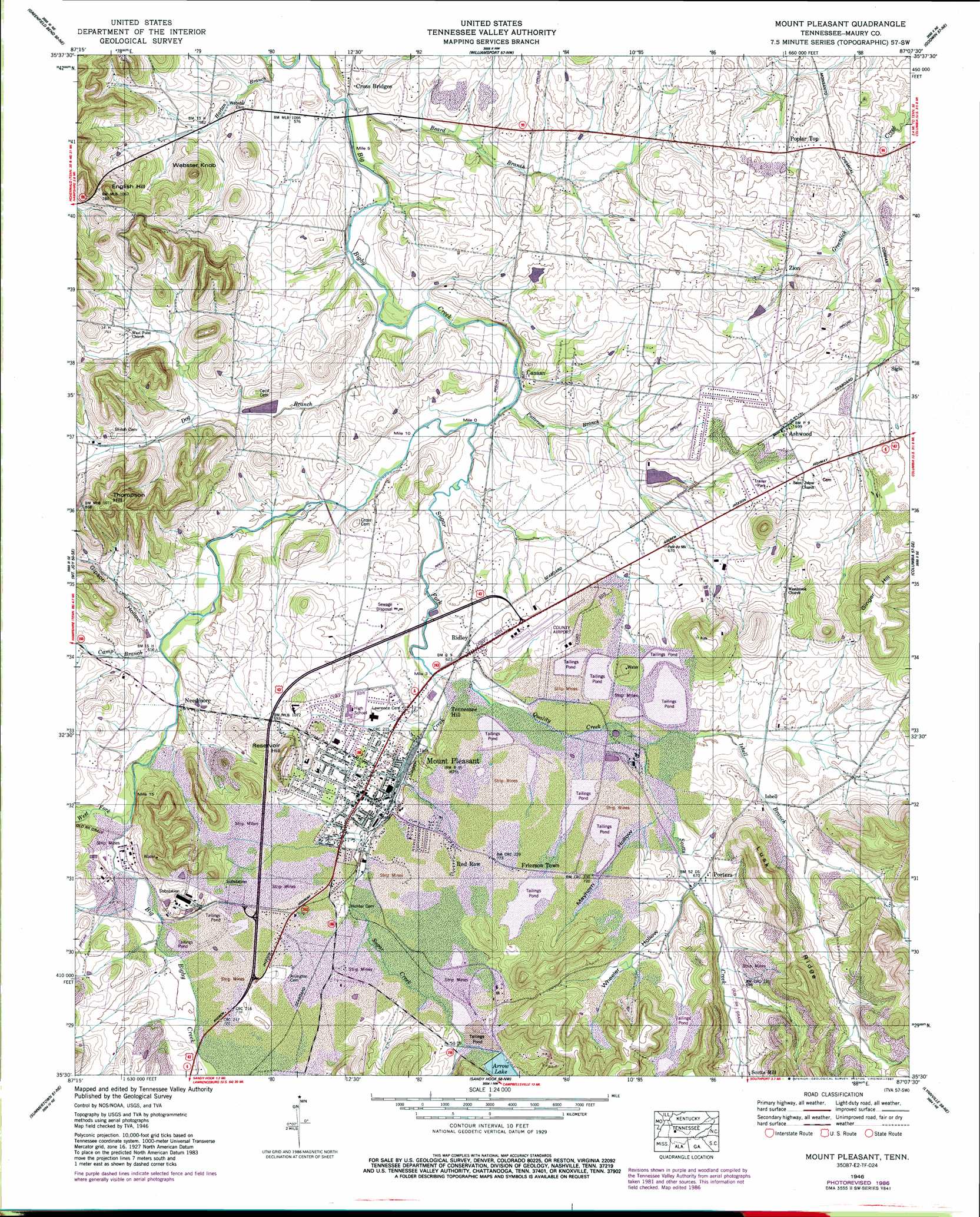
USGS Topo Quad 35087e2 - 1:24,000 scale
| Topo Map Name: | Mount Pleasant |
| USGS Topo Quad ID: | 35087e2 |
| Print Size: | ca. 21 1/4" wide x 27" high |
| Southeast Coordinates: | 35.5° N latitude / 87.125° W longitude |
| Map Center Coordinates: | 35.5625° N latitude / 87.1875° W longitude |
| U.S. State: | TN |
| Filename: | o35087e2.jpg |
| Download Map JPG Image: | Mount Pleasant topo map 1:24,000 scale |
| Map Type: | Topographic |
| Topo Series: | 7.5´ |
| Map Scale: | 1:24,000 |
| Source of Map Images: | United States Geological Survey (USGS) |
| Alternate Map Versions: |
Mount Pleasant TN 1936 Download PDF Buy paper map Mount Pleasant TN 1946, updated 1987 Download PDF Buy paper map Mount Pleasant TN 1950 Download PDF Buy paper map Mount Pleasant TN 1950, updated 1969 Download PDF Buy paper map Mount Pleasant TN 2010 Download PDF Buy paper map Mount Pleasant TN 2013 Download PDF Buy paper map Mount Pleasant TN 2016 Download PDF Buy paper map |
1:24,000 Topo Quads surrounding Mount Pleasant
Centerville |
Littlelot |
Primm Springs |
Theta |
Spring Hill |
Sunrise |
Greenfield Bend |
Williamsport |
Godwin |
Carters Creek |
Gordonsburg |
Mount Joy |
Mount Pleasant |
Columbia |
Glendale |
Henryville |
Summertown |
Sandy Hook |
Lynnville |
Campbells Station |
Deerfield |
Ethridge |
Campbellsville |
Milky Way |
Brick Church |
> Back to 35087e1 at 1:100,000 scale
> Back to 35086a1 at 1:250,000 scale
> Back to U.S. Topo Maps home
Mount Pleasant topo map: Gazetteer
Mount Pleasant: Airports
Maury County Airport elevation 201m 659′Mount Pleasant: Dams
Arrow Lake Dam elevation 217m 711′Bobs Lake Number One Dam elevation 236m 774′
Bobs Lake Number Two Dam elevation 252m 826′
Campbell Lake Dam elevation 191m 626′
Stauffer Chemical Dike Number Nineteen elevation 228m 748′
Stauffer Chemical Dike Number Seventeen elevation 195m 639′
Stauffer Globe Pond Dam Number Twenty-one elevation 195m 639′
Mount Pleasant: Mines
Davis Mine elevation 231m 757′Maury County Airport Mine elevation 195m 639′
Victor Mine elevation 190m 623′
Virginia-Carolina Mine elevation 238m 780′
Mount Pleasant: Parks
Gardenia Park elevation 207m 679′Howard Field Park elevation 209m 685′
Mount Pleasant Little League Park elevation 210m 688′
Mount Pleasant: Populated Places
Arrow elevation 224m 734′Ashwood elevation 214m 702′
Bigby (historical) elevation 192m 629′
Canaan elevation 180m 590′
Frierson Town elevation 223m 731′
Isbell elevation 210m 688′
Jonesboro (historical) elevation 200m 656′
Mount Pleasant elevation 206m 675′
Needmore elevation 193m 633′
Poplar Top elevation 208m 682′
Porters elevation 204m 669′
Red Row elevation 217m 711′
Ridley elevation 193m 633′
Siglo elevation 198m 649′
Zion elevation 194m 636′
Mount Pleasant: Post Offices
Mount Pleasant Post Office elevation 204m 669′Mount Pleasant: Reservoirs
Arrow Lake elevation 217m 711′Bobs Lake Number One elevation 236m 774′
Bobs Lake Number Two elevation 252m 826′
Campbell Lake elevation 191m 626′
Stauffer Chemical Tailings Pond Number Nineteen elevation 228m 748′
Stauffer Chemical Tailings Pond Number Seventeen elevation 195m 639′
Stauffer Globe Pond Number Twenty-one elevation 195m 639′
Mount Pleasant: Ridges
Lusk Ridge elevation 236m 774′Mount Pleasant: Streams
Beard Branch elevation 167m 547′Camp Branch elevation 186m 610′
Dog Branch elevation 171m 561′
Gipson Hollow Branch elevation 185m 606′
Isbell Branch elevation 198m 649′
Long Branch elevation 194m 636′
Patterson Branch elevation 175m 574′
Quality Creek elevation 184m 603′
Scotts Creek elevation 194m 636′
Sugar Creek elevation 184m 603′
Sugar Fork elevation 176m 577′
West Fork Big Bigby Creek elevation 190m 623′
Mount Pleasant: Summits
English Hill elevation 269m 882′Ginger Hill elevation 273m 895′
Institute Hill elevation 205m 672′
Reservoir Hill elevation 263m 862′
Thompson Hill elevation 263m 862′
Webster Knob elevation 263m 862′
Mount Pleasant: Valleys
Gipson Hollow elevation 186m 610′Mayhorn Hollow elevation 198m 649′
Wheeler Hollow elevation 201m 659′
Mount Pleasant digital topo map on disk
Buy this Mount Pleasant topo map showing relief, roads, GPS coordinates and other geographical features, as a high-resolution digital map file on DVD: