Godwin Topo Map Tennessee
To zoom in, hover over the map of Godwin
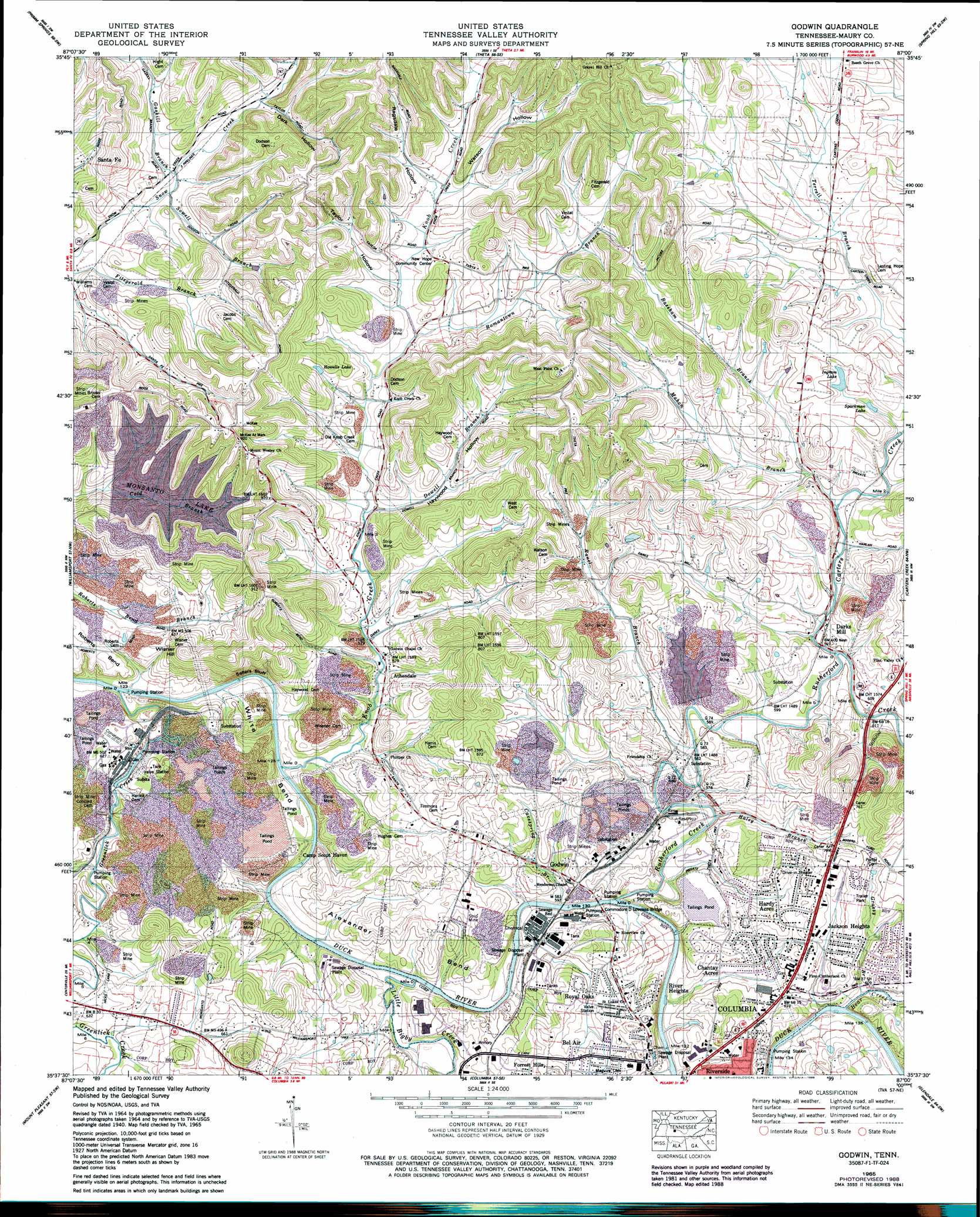
USGS Topo Quad 35087f1 - 1:24,000 scale
| Topo Map Name: | Godwin |
| USGS Topo Quad ID: | 35087f1 |
| Print Size: | ca. 21 1/4" wide x 27" high |
| Southeast Coordinates: | 35.625° N latitude / 87° W longitude |
| Map Center Coordinates: | 35.6875° N latitude / 87.0625° W longitude |
| U.S. State: | TN |
| Filename: | o35087f1.jpg |
| Download Map JPG Image: | Godwin topo map 1:24,000 scale |
| Map Type: | Topographic |
| Topo Series: | 7.5´ |
| Map Scale: | 1:24,000 |
| Source of Map Images: | United States Geological Survey (USGS) |
| Alternate Map Versions: |
Godwin TN 1936 Download PDF Buy paper map Godwin TN 1940, updated 1954 Download PDF Buy paper map Godwin TN 1941 Download PDF Buy paper map Godwin TN 1965, updated 1967 Download PDF Buy paper map Godwin TN 1965, updated 1980 Download PDF Buy paper map Godwin TN 1965, updated 1989 Download PDF Buy paper map Godwin TN 2010 Download PDF Buy paper map Godwin TN 2013 Download PDF Buy paper map Godwin TN 2016 Download PDF Buy paper map |
1:24,000 Topo Quads surrounding Godwin
Lyles |
Craigfield |
Fairview |
Leipers Fork |
Franklin |
Littlelot |
Primm Springs |
Theta |
Spring Hill |
Bethesda |
Greenfield Bend |
Williamsport |
Godwin |
Carters Creek |
Rally Hill |
Mount Joy |
Mount Pleasant |
Columbia |
Glendale |
Verona |
Summertown |
Sandy Hook |
Lynnville |
Campbells Station |
Lewisburg |
> Back to 35087e1 at 1:100,000 scale
> Back to 35086a1 at 1:250,000 scale
> Back to U.S. Topo Maps home
Godwin topo map: Gazetteer
Godwin: Bends
Alexander Bend elevation 202m 662′White Bend elevation 199m 652′
Godwin: Bridges
Commodore D Loveless Bridge elevation 168m 551′Rutherford Bridge (historical) elevation 176m 577′
Godwin: Cliffs
Sellers Bluff elevation 189m 620′Godwin: Crossings
Bookers Ferry (historical) elevation 161m 528′Godwin: Dams
Hooker Number Six Dam elevation 170m 557′Hooker Tailings Pond Number Ten Dam elevation 192m 629′
Monsanto Number Fifteen Dam elevation 229m 751′
Monsanto Tailings Pond Number Five Dam elevation 183m 600′
Monsanto Tailings Pond Number Four Dam elevation 170m 557′
Monsanto Tailings Pond Number Three Dam elevation 187m 613′
Presnell Tailings Pond Dam elevation 204m 669′
Tailings Pond Number Seven Dam elevation 193m 633′
Godwin: Mines
Murphy and Rone Mine elevation 226m 741′Parks Mine elevation 237m 777′
Sellers Mine elevation 201m 659′
Taylor Mine elevation 208m 682′
West Mine elevation 245m 803′
Godwin: Parks
Betty Lee Park elevation 198m 649′Godwin: Populated Places
Athendale elevation 173m 567′Bel Air elevation 196m 643′
Ben (historical) elevation 184m 603′
Chantay Acres elevation 191m 626′
Concord (historical) elevation 186m 610′
Flint Valley (historical) elevation 195m 639′
Godwin elevation 192m 629′
Hardy Acres elevation 200m 656′
Jackson Heights elevation 202m 662′
Kraus (historical) elevation 177m 580′
Latta (historical) elevation 279m 915′
Mowd (historical) elevation 205m 672′
Natco elevation 183m 600′
New Hope elevation 216m 708′
River Heights elevation 193m 633′
Royal Oaks elevation 186m 610′
Godwin: Reservoirs
Hooker Number Six Tailings Pond elevation 170m 557′Howells Lake elevation 208m 682′
Ingram Lake elevation 202m 662′
Monsanto Number Fifteen Lake elevation 229m 751′
Presnell Tailings Pond elevation 204m 669′
Sparkman Lake elevation 188m 616′
Tailings Pond Number Five elevation 183m 600′
Tailings Pond Number Four elevation 170m 557′
Tailings Pond Number Seven elevation 193m 633′
Tailings Pond Number Ten elevation 192m 629′
Tailings Pond Number Three elevation 187m 613′
Godwin: Streams
Allen Branch elevation 170m 557′Bassham Branch elevation 177m 580′
Bear Creek elevation 170m 557′
Carters Creek elevation 177m 580′
Cavespring Branch elevation 163m 534′
Dowell Branch elevation 182m 597′
Gaskill Branch elevation 195m 639′
Gin Branch elevation 170m 557′
Grassy Branch elevation 170m 557′
Greenlick Creek elevation 162m 531′
Haley Branch elevation 167m 547′
Knob Creek elevation 161m 528′
Little Bigby Creek elevation 165m 541′
Mahon Branch elevation 182m 597′
Ranel Branch elevation 171m 561′
Romantown Branch elevation 193m 633′
Rutherford Creek elevation 162m 531′
Sowell Branch elevation 194m 636′
Godwin: Summits
Foxall Hill elevation 268m 879′Green Hill elevation 233m 764′
Tea Hill elevation 256m 839′
Wisner Hill elevation 269m 882′
Godwin: Valleys
Dark Hollow elevation 202m 662′Haywood Hollow elevation 182m 597′
Ragsdale Hollow elevation 211m 692′
Sutherland Hollow elevation 215m 705′
Taylor Hollow elevation 198m 649′
Watson Hollow elevation 206m 675′
Godwin digital topo map on disk
Buy this Godwin topo map showing relief, roads, GPS coordinates and other geographical features, as a high-resolution digital map file on DVD: