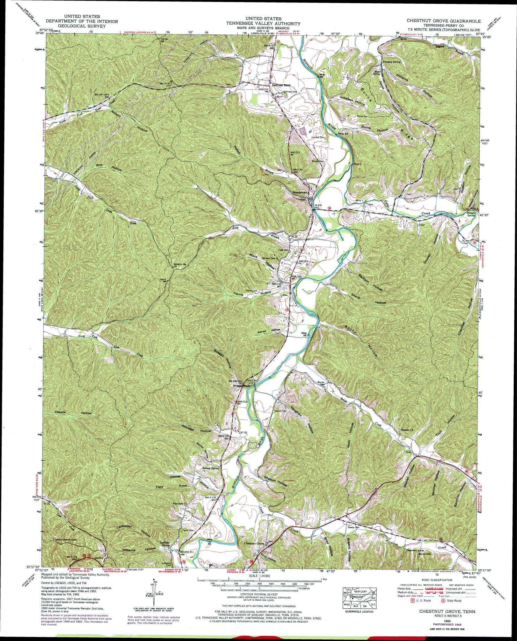
Chestnut Grove Topo Map Tennessee
To zoom in, hover over the map of Chestnut Grove
USGS Topo Quad 35087f7 - 1:24,000 scale
| Topo Map Name: | Chestnut Grove |
| USGS Topo Quad ID: | 35087f7 |
| Print Size: | ca. 21 1/4" wide x 27" high |
| Southeast Coordinates: | 35.625° N latitude / 87.75° W longitude |
| Map Center Coordinates: | 35.6875° N latitude / 87.8125° W longitude |
| U.S. State: | TN |
| Filename: | o35087f7.jpg |
| Download Map JPG Image: | Chestnut Grove topo map 1:24,000 scale |
| Map Type: | Topographic |
| Topo Series: | 7.5´ |
| Map Scale: | 1:24,000 |
| Source of Map Images: | United States Geological Survey (USGS) |
| Alternate Map Versions: |
Chestnut Grove TN 1936 Download PDF Buy paper map Chestnut Grove TN 1950, updated 1953 Download PDF Buy paper map Chestnut Grove TN 1950, updated 1970 Download PDF Buy paper map Chestnut Grove TN 2010 Download PDF Buy paper map Chestnut Grove TN 2013 Download PDF Buy paper map Chestnut Grove TN 2016 Download PDF Buy paper map |
1:24,000 Topo Quads surrounding Chestnut Grove
Rockport |
Hustburg |
Hurricane Mills |
Bucksnort |
Spot |
Sugar Tree |
Daniels Landing |
Lobelville |
Coble |
Whitfield |
Jeanette |
Pine View |
Chestnut Grove |
Pleasantville |
Beaverdam Springs |
Perryville |
Pope |
Linden |
Graves Spring |
Kimmins |
Bath Springs |
Clifton |
Leatherwood |
Topsy |
Riverside |
> Back to 35087e1 at 1:100,000 scale
> Back to 35086a1 at 1:250,000 scale
> Back to U.S. Topo Maps home
Chestnut Grove topo map: Gazetteer
Chestnut Grove: Cliffs
Scaggs Bluff elevation 166m 544′Chestnut Grove: Populated Places
Beardstown elevation 156m 511′Chestnut Grove elevation 183m 600′
DePriest Bend elevation 151m 495′
Chestnut Grove: Ridges
Burns Ridge elevation 190m 623′Chestnut Grove: Springs
Bates Spring elevation 143m 469′Hinson Spring elevation 149m 488′
Ledbetter Spring elevation 152m 498′
Rainey Spring elevation 154m 505′
Twomey Spring elevation 139m 456′
Chestnut Grove: Streams
Brush Creek elevation 138m 452′Cane Creek elevation 134m 439′
Coon Creek elevation 143m 469′
Fall Branch elevation 146m 479′
King Branch elevation 137m 449′
Lower Sinking Creek elevation 144m 472′
Pinhook Branch elevation 138m 452′
Taylor Branch elevation 152m 498′
Chestnut Grove: Valleys
Aldridge Hollow elevation 142m 465′Apple Orchard Hollow elevation 152m 498′
Barham Hollow elevation 137m 449′
Baucom Hollow elevation 156m 511′
Burns Hollow elevation 135m 442′
Comer Hollow elevation 145m 475′
Crowell Hollow elevation 142m 465′
Harris Hollow elevation 140m 459′
Hinson Hollow elevation 145m 475′
Isom Hollow elevation 146m 479′
Jones Hollow elevation 136m 446′
Kittrell Hollow elevation 145m 475′
Ledbetter Hollow elevation 152m 498′
Loveless Hollow elevation 135m 442′
Mack Hollow elevation 140m 459′
Nelson Hollow elevation 173m 567′
Rainey Hollow elevation 143m 469′
Rob Hollow elevation 163m 534′
Rocky Hollow elevation 139m 456′
Rogers Hollow elevation 148m 485′
Rosson Hollow elevation 146m 479′
Scaggs Hollow elevation 145m 475′
Sharp Hollow elevation 138m 452′
Shay Hollow elevation 147m 482′
Shelton Hollow elevation 144m 472′
Shop Hollow elevation 158m 518′
Skinner Hollow elevation 157m 515′
Toad Hollow elevation 179m 587′
Trull Hollow elevation 156m 511′
Vaughan Hollow elevation 144m 472′
Warren Hollow elevation 152m 498′
Williams Hollow elevation 140m 459′
Williams Hollow elevation 157m 515′
Chestnut Grove digital topo map on disk
Buy this Chestnut Grove topo map showing relief, roads, GPS coordinates and other geographical features, as a high-resolution digital map file on DVD: