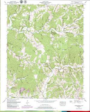
Primm Springs Topo Map Tennessee
To zoom in, hover over the map of Primm Springs
USGS Topo Quad 35087g2 - 1:24,000 scale
| Topo Map Name: | Primm Springs |
| USGS Topo Quad ID: | 35087g2 |
| Print Size: | ca. 21 1/4" wide x 27" high |
| Southeast Coordinates: | 35.75° N latitude / 87.125° W longitude |
| Map Center Coordinates: | 35.8125° N latitude / 87.1875° W longitude |
| U.S. State: | TN |
| Filename: | o35087g2.jpg |
| Download Map JPG Image: | Primm Springs topo map 1:24,000 scale |
| Map Type: | Topographic |
| Topo Series: | 7.5´ |
| Map Scale: | 1:24,000 |
| Source of Map Images: | United States Geological Survey (USGS) |
| Alternate Map Versions: |
Primm TN 1936 Download PDF Buy paper map Primm Springs TN 1951, updated 1957 Download PDF Buy paper map Primm Springs TN 1951, updated 1957 Download PDF Buy paper map Primm Springs TN 1951, updated 1980 Download PDF Buy paper map Primm Springs TN 2010 Download PDF Buy paper map Primm Springs TN 2013 Download PDF Buy paper map Primm Springs TN 2016 Download PDF Buy paper map |
1:24,000 Topo Quads surrounding Primm Springs
> Back to 35087e1 at 1:100,000 scale
> Back to 35086a1 at 1:250,000 scale
> Back to U.S. Topo Maps home
Primm Springs topo map: Gazetteer
Primm Springs: Cliffs
Worley Bluff elevation 201m 659′Primm Springs: Crossings
Piner Ford elevation 185m 606′Primm Springs: Populated Places
Beasley Crossroads elevation 287m 941′Fly elevation 198m 649′
Greenbrier elevation 256m 839′
Hill Town elevation 281m 921′
Johnsons Mill elevation 190m 623′
Kinderhook elevation 250m 820′
Leatherwood (historical) elevation 198m 649′
Lick Creek (historical) elevation 179m 587′
Mayberry (historical) elevation 236m 774′
McKnight elevation 205m 672′
Mill Seat elevation 202m 662′
New Flys Village elevation 195m 639′
Whiteoak elevation 204m 669′
Primm Springs: Ridges
Burr Ridge elevation 282m 925′Hominy Ridge elevation 274m 898′
Lick Ridge elevation 245m 803′
Primm Springs: Springs
Hunting Camp Spring elevation 247m 810′Primm Springs elevation 195m 639′
Primm Springs: Streams
Adkison Branch elevation 201m 659′Barren Fork elevation 173m 567′
Big Branch elevation 212m 695′
Black Branch elevation 207m 679′
Byrd Branch elevation 207m 679′
Charter Branch elevation 177m 580′
Daniel Branch elevation 201m 659′
Davidson Branch elevation 191m 626′
Edwards Branch elevation 187m 613′
Elam Branch elevation 195m 639′
Hanes Branch elevation 182m 597′
Harris Branch elevation 217m 711′
Hastings Branch elevation 210m 688′
Hill Branch elevation 195m 639′
Hunting Camp Branch elevation 206m 675′
Indian Camp Branch elevation 200m 656′
Kelley Branch elevation 196m 643′
Kinderhook Branch elevation 189m 620′
Little Dam Branch elevation 215m 705′
Locust Fork elevation 183m 600′
Lunns Branch elevation 177m 580′
McCoy Branch elevation 182m 597′
North Fork Lick Creek elevation 204m 669′
Oakley Mill Branch elevation 188m 616′
Oakley Mill Creek elevation 195m 639′
Page Branch elevation 192m 629′
Pennywinkle Branch elevation 200m 656′
Porters Branch elevation 196m 643′
Potts Branch elevation 186m 610′
Puckett Branch elevation 187m 613′
Shoal Branch elevation 194m 636′
Simon Branch elevation 207m 679′
South Fork Lick Creek elevation 204m 669′
Tyler Branch elevation 178m 583′
Warf Branch elevation 181m 593′
Primm Springs: Summits
Elam Hill elevation 282m 925′Gordon Hill elevation 250m 820′
High Ground elevation 292m 958′
Oil Well Hill elevation 262m 859′
Vestal Hill elevation 281m 921′
Primm Springs: Valleys
Badger Hollow elevation 179m 587′Bibbs Hollow elevation 186m 610′
Boneyard Hollow elevation 200m 656′
Box Hollow elevation 233m 764′
Brady Hollow elevation 195m 639′
Dorton Hollow elevation 199m 652′
Fly Hollow elevation 200m 656′
Forked Deer Hollow elevation 206m 675′
Grindstone Hollow elevation 201m 659′
Hogan Hollow elevation 193m 633′
Jenny Patch Hollow elevation 204m 669′
Johnson Hollow elevation 218m 715′
Jones Hollow elevation 187m 613′
Kelley Hollow elevation 200m 656′
Nellums Hollow elevation 199m 652′
Roach Hollow elevation 183m 600′
Shop Hollow elevation 215m 705′
Shouse Hollow elevation 224m 734′
Steam Mill Hollow elevation 181m 593′
Stephens Hollow elevation 189m 620′
Stillhouse Hollow elevation 193m 633′
Tunnel Hollow elevation 187m 613′
Wildcat Hollow elevation 188m 616′
Primm Springs digital topo map on disk
Buy this Primm Springs topo map showing relief, roads, GPS coordinates and other geographical features, as a high-resolution digital map file on DVD:


