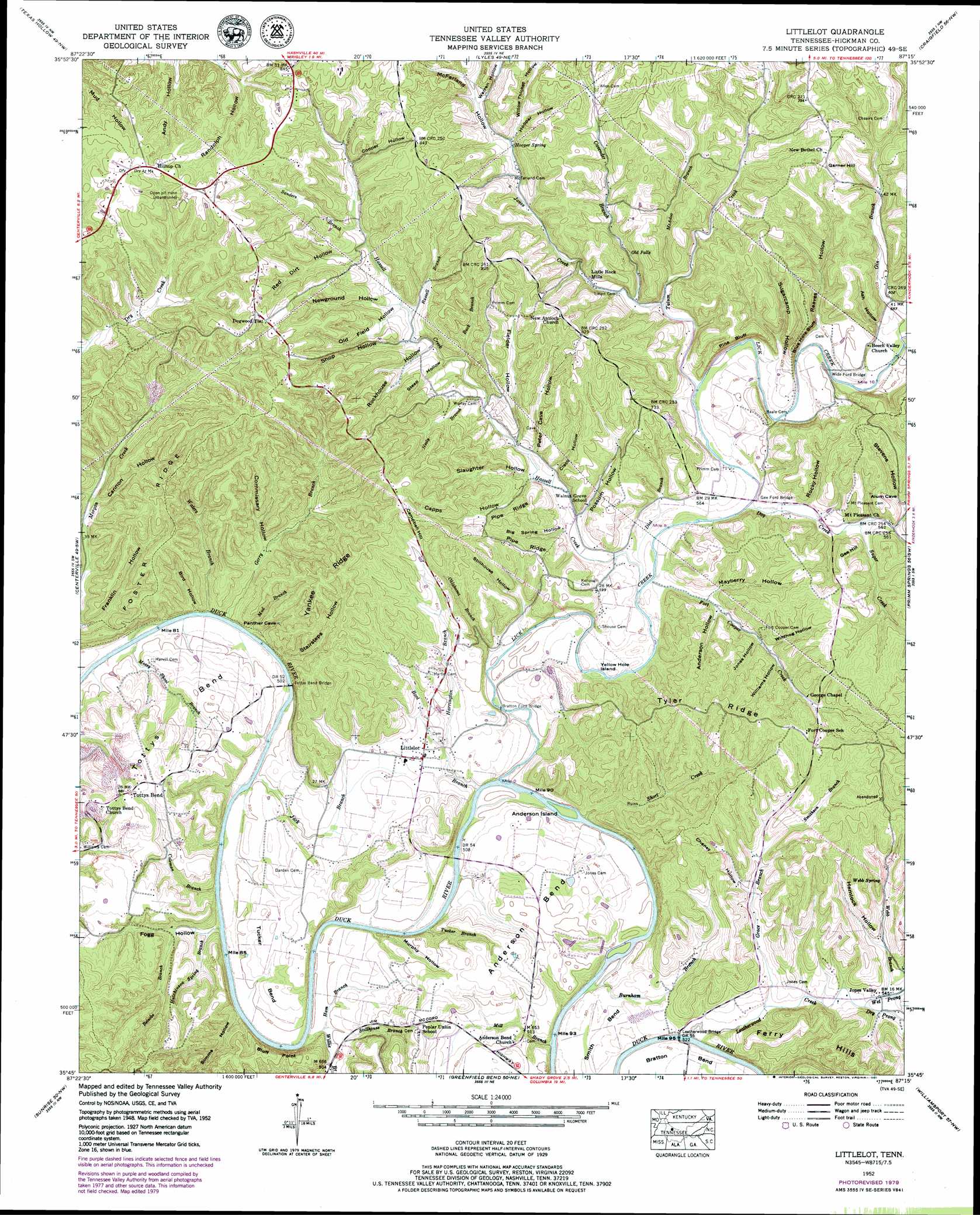
Littlelot Topo Map Tennessee
To zoom in, hover over the map of Littlelot
USGS Topo Quad 35087g3 - 1:24,000 scale
| Topo Map Name: | Littlelot |
| USGS Topo Quad ID: | 35087g3 |
| Print Size: | ca. 21 1/4" wide x 27" high |
| Southeast Coordinates: | 35.75° N latitude / 87.25° W longitude |
| Map Center Coordinates: | 35.8125° N latitude / 87.3125° W longitude |
| U.S. State: | TN |
| Filename: | o35087g3.jpg |
| Download Map JPG Image: | Littlelot topo map 1:24,000 scale |
| Map Type: | Topographic |
| Topo Series: | 7.5´ |
| Map Scale: | 1:24,000 |
| Source of Map Images: | United States Geological Survey (USGS) |
| Alternate Map Versions: |
Littlelot TN 1936 Download PDF Buy paper map Littlelot TN 1952, updated 1957 Download PDF Buy paper map Littlelot TN 1952, updated 1980 Download PDF Buy paper map Littlelot TN 2010 Download PDF Buy paper map Littlelot TN 2013 Download PDF Buy paper map Littlelot TN 2016 Download PDF Buy paper map |
1:24,000 Topo Quads surrounding Littlelot
Tennessee City |
Dickson |
Burns |
White Bluff |
Kingston Springs |
Spot |
Texas Hollow |
Lyles |
Craigfield |
Fairview |
Whitfield |
Centerville |
Littlelot |
Primm Springs |
Theta |
Beaverdam Springs |
Sunrise |
Greenfield Bend |
Williamsport |
Godwin |
Kimmins |
Gordonsburg |
Mount Joy |
Mount Pleasant |
Columbia |
> Back to 35087e1 at 1:100,000 scale
> Back to 35086a1 at 1:250,000 scale
> Back to U.S. Topo Maps home
Littlelot topo map: Gazetteer
Littlelot: Bends
Anderson Bend elevation 182m 597′Smith Bend elevation 159m 521′
Tottys Bend elevation 202m 662′
Tucker Bend elevation 166m 544′
Littlelot: Bridges
Anderson Bend Bridge elevation 142m 465′Bratton Ford Bridge elevation 149m 488′
Gee Ford Bridge elevation 159m 521′
Leatherwood Bridge elevation 149m 488′
Tottys Bend Bridge elevation 143m 469′
Wide Ford Bridge elevation 169m 554′
Littlelot: Cliffs
Blue Hole Bluff elevation 222m 728′Bluff Point elevation 180m 590′
Pine Bluff elevation 227m 744′
Littlelot: Crossings
Bratton Ford elevation 149m 488′Harrill Ford elevation 148m 485′
Wide Ford elevation 173m 567′
Littlelot: Dams
M C West Tailings Pond Dam elevation 172m 564′Littlelot: Islands
Anderson Island elevation 142m 465′Yellow Hole Island elevation 156m 511′
Littlelot: Mines
Anderson Bend Mine elevation 197m 646′Coleman Branch Mine elevation 177m 580′
Fogg Hollow Mines elevation 184m 603′
Meadows Mine elevation 194m 636′
Tottys Bend Mines elevation 188m 616′
Waters Branch Prospects elevation 250m 820′
Worley Mine elevation 189m 620′
Worley Mine elevation 275m 902′
Littlelot: Populated Places
Beale (historical) elevation 184m 603′Bluffpoint (historical) elevation 213m 698′
Dogwood Flat elevation 277m 908′
Fogg (historical) elevation 180m 590′
Jones Valley elevation 165m 541′
Little Rock Mills elevation 179m 587′
Littlelot elevation 167m 547′
Primm Springs elevation 188m 616′
Tottys Bend elevation 211m 692′
Littlelot: Reservoirs
M C West Tailings Pond elevation 172m 564′Littlelot: Ridges
Foster Ridge elevation 247m 810′Pipe Ridge elevation 212m 695′
Tyler Ridge elevation 225m 738′
Yankee Ridge elevation 241m 790′
Littlelot: Springs
Hooper Spring elevation 199m 652′Webb Spring elevation 210m 688′
Littlelot: Streams
Betsobe Branch elevation 153m 501′Boot Branch elevation 146m 479′
Buck Branch elevation 177m 580′
Burnham Branch elevation 148m 485′
Cavender Branch elevation 172m 564′
Coleman Branch elevation 144m 472′
Dial Branch elevation 157m 515′
Dog Creek elevation 159m 521′
Dry Prong Leatherwood Creek elevation 162m 531′
Fort Cooper Creek elevation 156m 511′
Gerry Branch elevation 146m 479′
Gin Branch elevation 173m 567′
Grace Branch elevation 155m 508′
Ham Branch elevation 149m 488′
Harrington Branch elevation 158m 518′
Hassell Creek elevation 162m 531′
Hutchinson Spring Branch elevation 143m 469′
Jack Branch elevation 142m 465′
Jones Creek elevation 169m 554′
Leatherwood Creek elevation 151m 495′
Lick Creek elevation 150m 492′
McAdoo Branch elevation 188m 616′
Mill Branch elevation 149m 488′
Mossy Shoal Branch elevation 142m 465′
Mud Branch elevation 146m 479′
Neely Branch elevation 175m 574′
Oklahoma Branch elevation 153m 501′
Panther Branch elevation 146m 479′
Russell Branch elevation 187m 613′
Sanders Branch elevation 200m 656′
Short Creek elevation 145m 475′
Smithson Branch elevation 185m 606′
Stillhouse Branch elevation 149m 488′
Sugar Creek elevation 168m 551′
Tatum Creek elevation 162m 531′
Tucker Branch elevation 147m 482′
Waters Branch elevation 151m 495′
Webb Branch elevation 164m 538′
Wet Prong Leatherwood Creek elevation 162m 531′
Willie Branch elevation 142m 465′
Littlelot: Summits
Campbell Hill elevation 270m 885′Ferry Hills elevation 213m 698′
Garner Hill elevation 233m 764′
Gee Hill elevation 212m 695′
Littlelot: Valleys
Alum Cave Hollow elevation 175m 574′Anderson Hollow elevation 170m 557′
Ash Hollow elevation 178m 583′
Big Spring Hollow elevation 164m 538′
Bird Hollow elevation 151m 495′
Cannon Hollow elevation 165m 541′
Capps Hollow elevation 171m 561′
Cates Hollow elevation 205m 672′
Chaney Hollow elevation 178m 583′
Cisco Hollow elevation 177m 580′
Commissary Hollow elevation 162m 531′
Cooper Hollow elevation 207m 679′
Fielder Hollow elevation 206m 675′
Fogg Hollow elevation 143m 469′
Hemlock Hollow elevation 175m 574′
Hooper Hollow elevation 203m 666′
Jones Hollow elevation 174m 570′
Mayberry Hollow elevation 165m 541′
McFarland Hollow elevation 200m 656′
Murphy Hollow elevation 147m 482′
Newground Hollow elevation 197m 646′
Old Field Hollow elevation 196m 643′
Peter Cave Hollow elevation 171m 561′
Possum Hollow elevation 167m 547′
Reaves Hollow elevation 176m 577′
Red Dirt Hollow elevation 210m 688′
Rockhouse Hollow elevation 183m 600′
Rocky Hollow elevation 165m 541′
Shop Hollow elevation 191m 626′
Simms Hollow elevation 148m 485′
Slaughter Hollow elevation 169m 554′
Stairsteps Hollow elevation 159m 521′
Steep Hollow elevation 180m 590′
Stevens Hollow elevation 178m 583′
Stillhouse Hollow elevation 160m 524′
Sugarcamp Hollow elevation 173m 567′
Warren Hollow elevation 207m 679′
Williams Hollow elevation 183m 600′
Willow Thicket Hollow elevation 211m 692′
Littlelot digital topo map on disk
Buy this Littlelot topo map showing relief, roads, GPS coordinates and other geographical features, as a high-resolution digital map file on DVD: