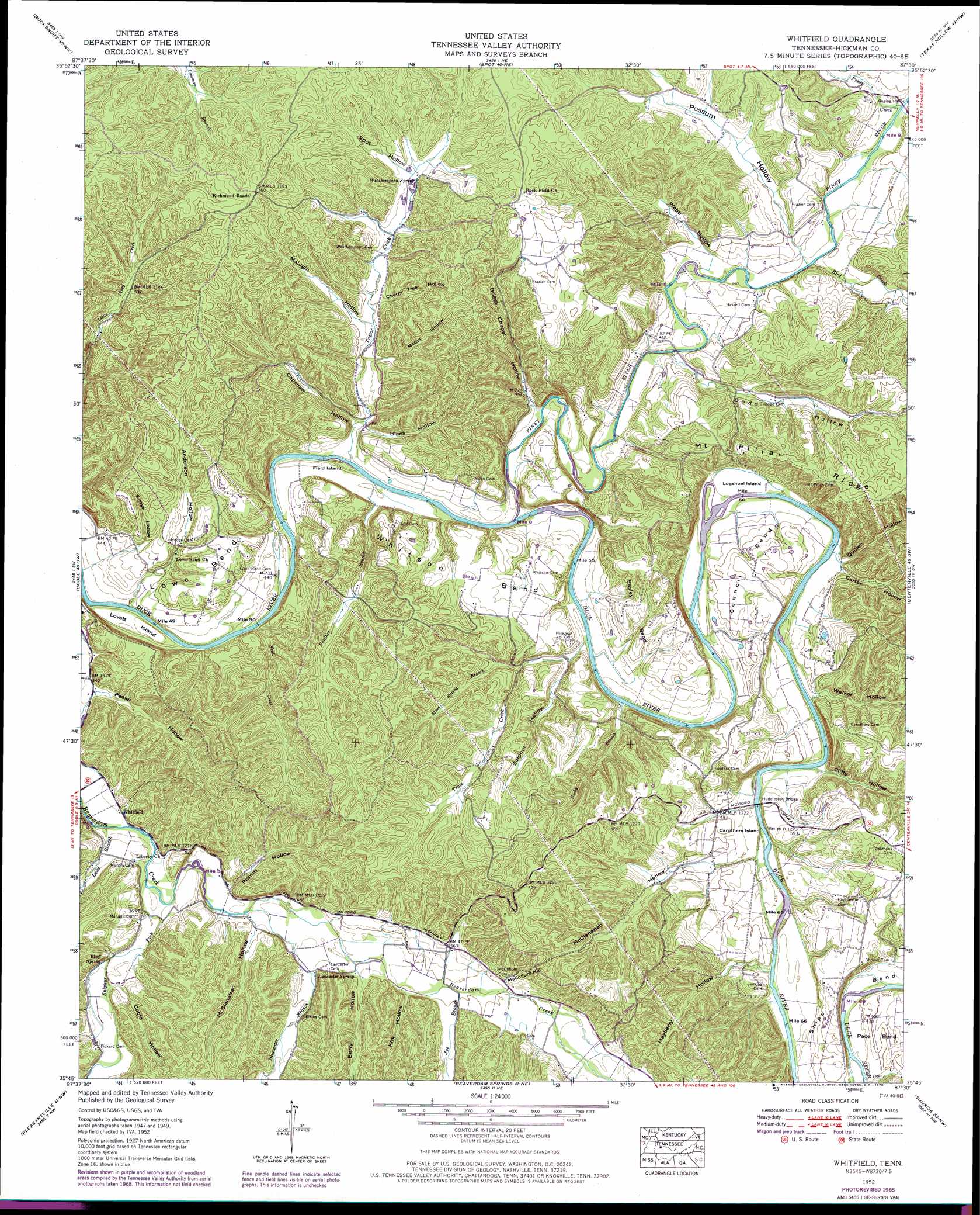
Whitfield Topo Map Tennessee
To zoom in, hover over the map of Whitfield
USGS Topo Quad 35087g5 - 1:24,000 scale
| Topo Map Name: | Whitfield |
| USGS Topo Quad ID: | 35087g5 |
| Print Size: | ca. 21 1/4" wide x 27" high |
| Southeast Coordinates: | 35.75° N latitude / 87.5° W longitude |
| Map Center Coordinates: | 35.8125° N latitude / 87.5625° W longitude |
| U.S. State: | TN |
| Filename: | o35087g5.jpg |
| Download Map JPG Image: | Whitfield topo map 1:24,000 scale |
| Map Type: | Topographic |
| Topo Series: | 7.5´ |
| Map Scale: | 1:24,000 |
| Source of Map Images: | United States Geological Survey (USGS) |
| Alternate Map Versions: |
Whitfield TN 1936 Download PDF Buy paper map Whitfield TN 1952, updated 1957 Download PDF Buy paper map Whitfield TN 1952, updated 1970 Download PDF Buy paper map Whitfield TN 2010 Download PDF Buy paper map Whitfield TN 2013 Download PDF Buy paper map Whitfield TN 2016 Download PDF Buy paper map |
1:24,000 Topo Quads surrounding Whitfield
Waverly |
Mcewen |
Tennessee City |
Dickson |
Burns |
Hurricane Mills |
Bucksnort |
Spot |
Texas Hollow |
Lyles |
Lobelville |
Coble |
Whitfield |
Centerville |
Littlelot |
Chestnut Grove |
Pleasantville |
Beaverdam Springs |
Sunrise |
Greenfield Bend |
Linden |
Graves Spring |
Kimmins |
Gordonsburg |
Mount Joy |
> Back to 35087e1 at 1:100,000 scale
> Back to 35086a1 at 1:250,000 scale
> Back to U.S. Topo Maps home
Whitfield topo map: Gazetteer
Whitfield: Bars
Eastern Shoal elevation 131m 429′Log Shoal elevation 133m 436′
Lovets Shoal elevation 128m 419′
Whitfield: Bends
Council Bend elevation 163m 534′Easley Bend elevation 175m 574′
Lowe Bend elevation 171m 561′
Pace Bend elevation 161m 528′
Shipp Bend elevation 170m 557′
Whitson Bend elevation 175m 574′
Whitfield: Bridges
Huddleston Bridge elevation 133m 436′Whitfield: Crossings
Hicks Ford elevation 128m 419′Huddlestons Ford elevation 133m 436′
Scotts Ford elevation 128m 419′
Whitfield: Islands
Carothers Island elevation 134m 439′Field Island elevation 128m 419′
Logshoal Island elevation 136m 446′
Lovett Island elevation 131m 429′
Whitfield: Populated Places
Whitfield elevation 138m 452′Whitfield: Ridges
Mount Pillar Ridge elevation 235m 770′Whitfield: Springs
Bluff Spring elevation 145m 475′Lancaster Spring elevation 157m 515′
Oil Spring elevation 165m 541′
Weatherspoon Spring elevation 165m 541′
Whitfield: Streams
Bird Creek elevation 138m 452′Bluewater Branch elevation 143m 469′
Joe Branch elevation 151m 495′
Lowe Branch elevation 136m 446′
Moss Spring Branch elevation 142m 465′
Muddy Branch elevation 145m 475′
Panther Branch elevation 134m 439′
Piney River elevation 128m 419′
Pretty Creek elevation 145m 475′
Rocky Branch elevation 131m 429′
Skull Creek elevation 128m 419′
Sulphur Fork elevation 138m 452′
Taylor Creek elevation 128m 419′
Trace Creek elevation 130m 426′
Whitfield: Summits
McCollum Hill elevation 222m 728′Whitfield: Valleys
Anderson Hollow elevation 132m 433′Berry Hollow elevation 149m 488′
Black Hollow elevation 135m 442′
Bridge Hollow elevation 136m 446′
Briggs Chapel Hollow elevation 140m 459′
Capshaw Hollow elevation 131m 429′
Carter Hollow elevation 139m 456′
Cherry Tree Hollow elevation 152m 498′
Clifty Hollow elevation 142m 465′
Coble Hollow elevation 143m 469′
Dodd Hollow elevation 135m 442′
Kirk Hollow elevation 150m 492′
Malugin Hollow elevation 148m 485′
Mayberry Hollow elevation 140m 459′
McClanahan Hollow elevation 139m 456′
McClanahan Hollow elevation 147m 482′
McGill Hollow elevation 145m 475′
Peeler Hollow elevation 136m 446′
Possum Hollow elevation 142m 465′
Primm Hollow elevation 144m 472′
Quillen Hollow elevation 138m 452′
Spot Hollow elevation 170m 557′
Sulphur Hollow elevation 134m 439′
Tarkiln Hollow elevation 148m 485′
Walker Hollow elevation 134m 439′
Webb Hollow elevation 140m 459′
Whitfield digital topo map on disk
Buy this Whitfield topo map showing relief, roads, GPS coordinates and other geographical features, as a high-resolution digital map file on DVD: