Bucksnort Topo Map Tennessee
To zoom in, hover over the map of Bucksnort
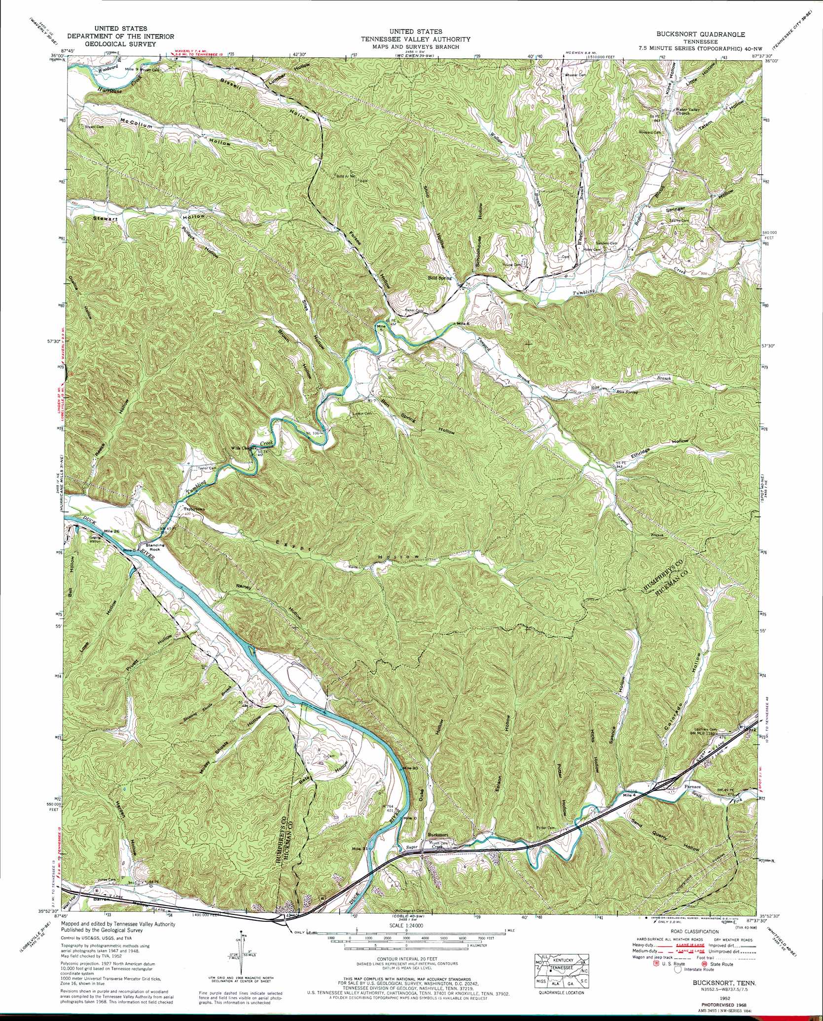
USGS Topo Quad 35087h6 - 1:24,000 scale
| Topo Map Name: | Bucksnort |
| USGS Topo Quad ID: | 35087h6 |
| Print Size: | ca. 21 1/4" wide x 27" high |
| Southeast Coordinates: | 35.875° N latitude / 87.625° W longitude |
| Map Center Coordinates: | 35.9375° N latitude / 87.6875° W longitude |
| U.S. State: | TN |
| Filename: | o35087h6.jpg |
| Download Map JPG Image: | Bucksnort topo map 1:24,000 scale |
| Map Type: | Topographic |
| Topo Series: | 7.5´ |
| Map Scale: | 1:24,000 |
| Source of Map Images: | United States Geological Survey (USGS) |
| Alternate Map Versions: |
Bucksnort TN 1936 Download PDF Buy paper map Bucksnort TN 1952, updated 1957 Download PDF Buy paper map Bucksnort TN 1952, updated 1970 Download PDF Buy paper map Bucksnort TN 2010 Download PDF Buy paper map Bucksnort TN 2013 Download PDF Buy paper map Bucksnort TN 2016 Download PDF Buy paper map |
1:24,000 Topo Quads surrounding Bucksnort
Harmon Creek |
Halls Creek |
Woolworth |
Ruskin |
Vanleer |
Johnsonville |
Waverly |
Mcewen |
Tennessee City |
Dickson |
Hustburg |
Hurricane Mills |
Bucksnort |
Spot |
Texas Hollow |
Daniels Landing |
Lobelville |
Coble |
Whitfield |
Centerville |
Pine View |
Chestnut Grove |
Pleasantville |
Beaverdam Springs |
Sunrise |
> Back to 35087e1 at 1:100,000 scale
> Back to 35086a1 at 1:250,000 scale
> Back to U.S. Topo Maps home
Bucksnort topo map: Gazetteer
Bucksnort: Bars
Long Shoal elevation 113m 370′Bucksnort: Cliffs
Grandfathers Building elevation 171m 561′Bucksnort: Crossings
Interchange 152 elevation 144m 472′Bucksnort: Pillars
Standing Rock elevation 121m 396′Bucksnort: Populated Places
Bold Spring elevation 141m 462′Bucksnort elevation 126m 413′
Furnace elevation 146m 479′
Taylortown elevation 120m 393′
Water Valley elevation 165m 541′
Wills Chapel elevation 122m 400′
Bucksnort: Rapids
Bickerstaff Eddy elevation 115m 377′Bucksnort: Springs
Reece Spring elevation 123m 403′Rice Spring elevation 164m 538′
Bucksnort: Streams
Baptist Branch elevation 145m 475′Barren Hollow Branch elevation 116m 380′
Barren Hollow Branch elevation 115m 377′
Pullen Branch elevation 158m 518′
Rice Branch elevation 146m 479′
Slanting Shoals Branch elevation 116m 380′
Snake Creek elevation 119m 390′
South Fork Sugar Creek elevation 138m 452′
Sugar Creek elevation 113m 370′
Tanyard Branch elevation 135m 442′
Tumbling Creek elevation 114m 374′
Wallace Branch elevation 141m 462′
Wheeler Branch elevation 141m 462′
Woodward Branch elevation 132m 433′
Young Branch elevation 164m 538′
Bucksnort: Valleys
Bate Hollow elevation 124m 406′Bell Hollow elevation 117m 383′
Bissell Hollow elevation 134m 439′
Bon Spring Hollow elevation 132m 433′
Brown Hollow elevation 129m 423′
Colorado Hollow elevation 137m 449′
Duke Hollow elevation 123m 403′
Egypt Hollow elevation 119m 390′
Epison Hollow elevation 126m 413′
Ethridge Hollow elevation 164m 538′
Forsee Hollow elevation 136m 446′
Harden Hollow elevation 138m 452′
Hicks Hollow elevation 134m 439′
Kline Hollow elevation 158m 518′
Little Hollow elevation 170m 557′
Lowe Hollow elevation 117m 383′
Lumber Hollow elevation 151m 495′
McCollum Hollow elevation 134m 439′
Mossy Shoals Hollow elevation 118m 387′
Pollock Hollow elevation 158m 518′
Potter Hollow elevation 132m 433′
Pruett Hollow elevation 119m 390′
Rainey Hollow elevation 113m 370′
Reece Hollow elevation 119m 390′
Sand Quarry Hollow elevation 139m 456′
Schoolhouse Hollow elevation 142m 465′
Shop Hollow elevation 145m 475′
Silas Hollow elevation 134m 439′
Spence Hollow elevation 134m 439′
Spot Hollow elevation 140m 459′
Stringer Hollow elevation 153m 501′
Tatem Hollow elevation 157m 515′
Weatherspoon Hollow elevation 144m 472′
Well Hollow elevation 145m 475′
Wright Hollow elevation 183m 600′
Bucksnort digital topo map on disk
Buy this Bucksnort topo map showing relief, roads, GPS coordinates and other geographical features, as a high-resolution digital map file on DVD: