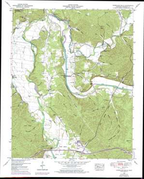
Hurricane Mills Topo Map Tennessee
To zoom in, hover over the map of Hurricane Mills
USGS Topo Quad 35087h7 - 1:24,000 scale
| Topo Map Name: | Hurricane Mills |
| USGS Topo Quad ID: | 35087h7 |
| Print Size: | ca. 21 1/4" wide x 27" high |
| Southeast Coordinates: | 35.875° N latitude / 87.75° W longitude |
| Map Center Coordinates: | 35.9375° N latitude / 87.8125° W longitude |
| U.S. State: | TN |
| Filename: | o35087h7.jpg |
| Download Map JPG Image: | Hurricane Mills topo map 1:24,000 scale |
| Map Type: | Topographic |
| Topo Series: | 7.5´ |
| Map Scale: | 1:24,000 |
| Source of Map Images: | United States Geological Survey (USGS) |
| Alternate Map Versions: |
Hurricane Mills TN 1936 Download PDF Buy paper map Hurricane Mills TN 1950, updated 1953 Download PDF Buy paper map Hurricane Mills TN 1950, updated 1970 Download PDF Buy paper map Hurricane Mills TN 2010 Download PDF Buy paper map Hurricane Mills TN 2013 Download PDF Buy paper map Hurricane Mills TN 2016 Download PDF Buy paper map |
1:24,000 Topo Quads surrounding Hurricane Mills
> Back to 35087e1 at 1:100,000 scale
> Back to 35086a1 at 1:250,000 scale
> Back to U.S. Topo Maps home
Hurricane Mills topo map: Gazetteer
Hurricane Mills: Bars
Hachie Shoal elevation 113m 370′Hurricane Mills: Basins
Cherry Bottom elevation 116m 380′Hurricane Mills: Bends
Owen Bottom elevation 125m 410′Parks Bottom elevation 119m 390′
Shipp Bottom elevation 123m 403′
The Whirl elevation 112m 367′
Hurricane Mills: Bridges
Link Bridge elevation 109m 357′Martin Ford Bridge (historical) elevation 115m 377′
Tanksley Bridge elevation 113m 370′
Hurricane Mills: Cliffs
Pace Bluff elevation 135m 442′Hurricane Mills: Crossings
Bones Ford elevation 112m 367′Hite Ford elevation 113m 370′
Interchange 143 elevation 139m 456′
Martin Ford elevation 115m 377′
Pace Ford elevation 119m 390′
Hurricane Mills: Gaps
Cedar Gap elevation 173m 567′Low Gap elevation 156m 511′
Hurricane Mills: Islands
Whirl Bar elevation 114m 374′Hurricane Mills: Lakes
Whery Lake elevation 113m 370′Hurricane Mills: Populated Places
Bakerville elevation 120m 393′Buffalo elevation 138m 452′
Caigletown elevation 139m 456′
Cedar Grove elevation 126m 413′
Hurricane Mills elevation 124m 406′
Hurricane Mills: Post Offices
Hurricane Mills Post Office elevation 123m 403′Hurricane Mills: Rapids
Will Rice Eddy elevation 113m 370′Hurricane Mills: Reservoirs
Parm Lick Pond elevation 189m 620′Hurricane Mills: Ridges
Walker Ridge elevation 199m 652′Hurricane Mills: Springs
Nolan Spring elevation 133m 436′Hurricane Mills: Streams
Baker Branch elevation 123m 403′Black Branch elevation 117m 383′
Bud Rock Branch elevation 116m 380′
Buffalo River elevation 110m 360′
Camp Branch elevation 116m 380′
Cold Branch elevation 116m 380′
Grassy Branch elevation 109m 357′
Hurricane Creek elevation 109m 357′
Luten Branch elevation 110m 360′
Mill Branch elevation 117m 383′
Stewart Branch elevation 124m 406′
Tanyard Branch elevation 118m 387′
Hurricane Mills: Summits
Fowlkes Hill elevation 181m 593′Jones Hill elevation 199m 652′
Rushing Hill elevation 204m 669′
Hurricane Mills: Valleys
Big Watered Hollow elevation 117m 383′Bone Hollow elevation 121m 396′
Brushy Hollow elevation 136m 446′
Coaling Hollow elevation 133m 436′
Cow Hollow elevation 135m 442′
Happy Hollow elevation 120m 393′
Hite Hollow elevation 124m 406′
Hutchinson Hollow elevation 120m 393′
Jackson Hollow elevation 120m 393′
Little Mill Hollow elevation 134m 439′
Little Watered Hollow elevation 198m 649′
Mason Hollow elevation 122m 400′
McMurray Hollow elevation 125m 410′
Mill Hollow elevation 124m 406′
Pace Hollow elevation 119m 390′
Page Hollow elevation 122m 400′
Pierce Hollow elevation 126m 413′
Railpen Hollow elevation 118m 387′
Reece Hollow elevation 136m 446′
Roberts Hollow elevation 129m 423′
Roberts Hollow elevation 126m 413′
Rock Quarry Hollow elevation 118m 387′
Sterling Hollow elevation 121m 396′
Stewart Hollow elevation 125m 410′
Stooping Hickory Hollow elevation 155m 508′
Toland Hollow elevation 152m 498′
Voorhies Hollow elevation 110m 360′
Hurricane Mills: Woods
Flat Woods elevation 141m 462′Hurricane Mills digital topo map on disk
Buy this Hurricane Mills topo map showing relief, roads, GPS coordinates and other geographical features, as a high-resolution digital map file on DVD:


