Chewalla Topo Map Tennessee
To zoom in, hover over the map of Chewalla
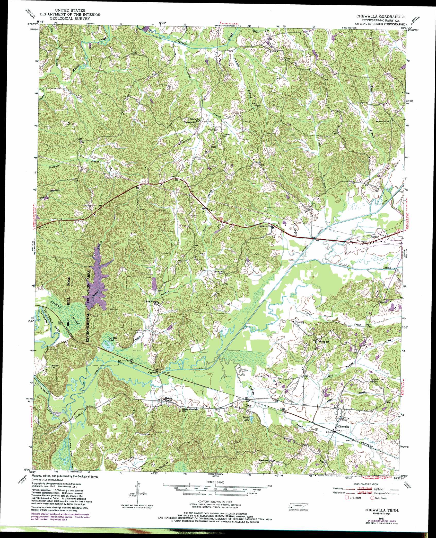
USGS Topo Quad 35088a6 - 1:24,000 scale
| Topo Map Name: | Chewalla |
| USGS Topo Quad ID: | 35088a6 |
| Print Size: | ca. 21 1/4" wide x 27" high |
| Southeast Coordinates: | 35° N latitude / 88.625° W longitude |
| Map Center Coordinates: | 35.0625° N latitude / 88.6875° W longitude |
| U.S. State: | TN |
| Filename: | o35088a6.jpg |
| Download Map JPG Image: | Chewalla topo map 1:24,000 scale |
| Map Type: | Topographic |
| Topo Series: | 7.5´ |
| Map Scale: | 1:24,000 |
| Source of Map Images: | United States Geological Survey (USGS) |
| Alternate Map Versions: |
Chewalla TN 1951, updated 1952 Download PDF Buy paper map Chewalla TN 1951, updated 1967 Download PDF Buy paper map Chewalla TN 1951, updated 1973 Download PDF Buy paper map Chewalla TN 1951, updated 1981 Download PDF Buy paper map Chewalla TN 1951, updated 1983 Download PDF Buy paper map Chewalla TN 2010 Download PDF Buy paper map Chewalla TN 2013 Download PDF Buy paper map Chewalla TN 2016 Download PDF Buy paper map |
1:24,000 Topo Quads surrounding Chewalla
Bolivar East |
Silerton |
Masseyville |
Mount Peter |
Leapwood |
Hebron |
Hornsby |
Rose Creek |
Purdy |
Stantonville |
Middleton |
Pocahontas |
Chewalla |
Guys |
Michie |
Walnut |
Chalybeate |
Kossuth North |
Corinth |
Kendrick |
Falkner |
Peoples |
Kossuth South |
Rienzi |
Glens |
> Back to 35088a1 at 1:100,000 scale
> Back to 35088a1 at 1:250,000 scale
> Back to U.S. Topo Maps home
Chewalla topo map: Gazetteer
Chewalla: Areas
Big Hill Pond State Park elevation 114m 374′Chewalla: Bends
Tan Yard Bend elevation 113m 370′Chewalla: Canals
Cypress Creek Ditch elevation 119m 390′Chewalla: Dams
Big Hill Pond Lake Dam elevation 117m 383′Chewalla: Lakes
Big Hill Pond elevation 115m 377′Chewalla: Populated Places
Chewalla elevation 125m 410′Cypress elevation 118m 387′
Chewalla: Post Offices
Chewalla Post Office elevation 125m 410′Chewalla: Reservoirs
Big Hill Pond Lake elevation 117m 383′Turner Lake elevation 126m 413′
Chewalla: Streams
Allen Branch elevation 122m 400′Boles Branch elevation 113m 370′
Caney Creek elevation 115m 377′
Cypress Creek elevation 113m 370′
Dismal Branch elevation 115m 377′
Dry Branch elevation 121m 396′
Indian Creek elevation 115m 377′
Jimmies Branch elevation 128m 419′
Little Indian Creek elevation 119m 390′
Muddy Creek elevation 117m 383′
Neatherly Branch elevation 126m 413′
Ramer Branch elevation 118m 387′
Reedy Branch elevation 118m 387′
Chewalla: Swamps
Dismal Swamp elevation 113m 370′Chewalla digital topo map on disk
Buy this Chewalla topo map showing relief, roads, GPS coordinates and other geographical features, as a high-resolution digital map file on DVD: