Pocahontas Topo Map Tennessee
To zoom in, hover over the map of Pocahontas
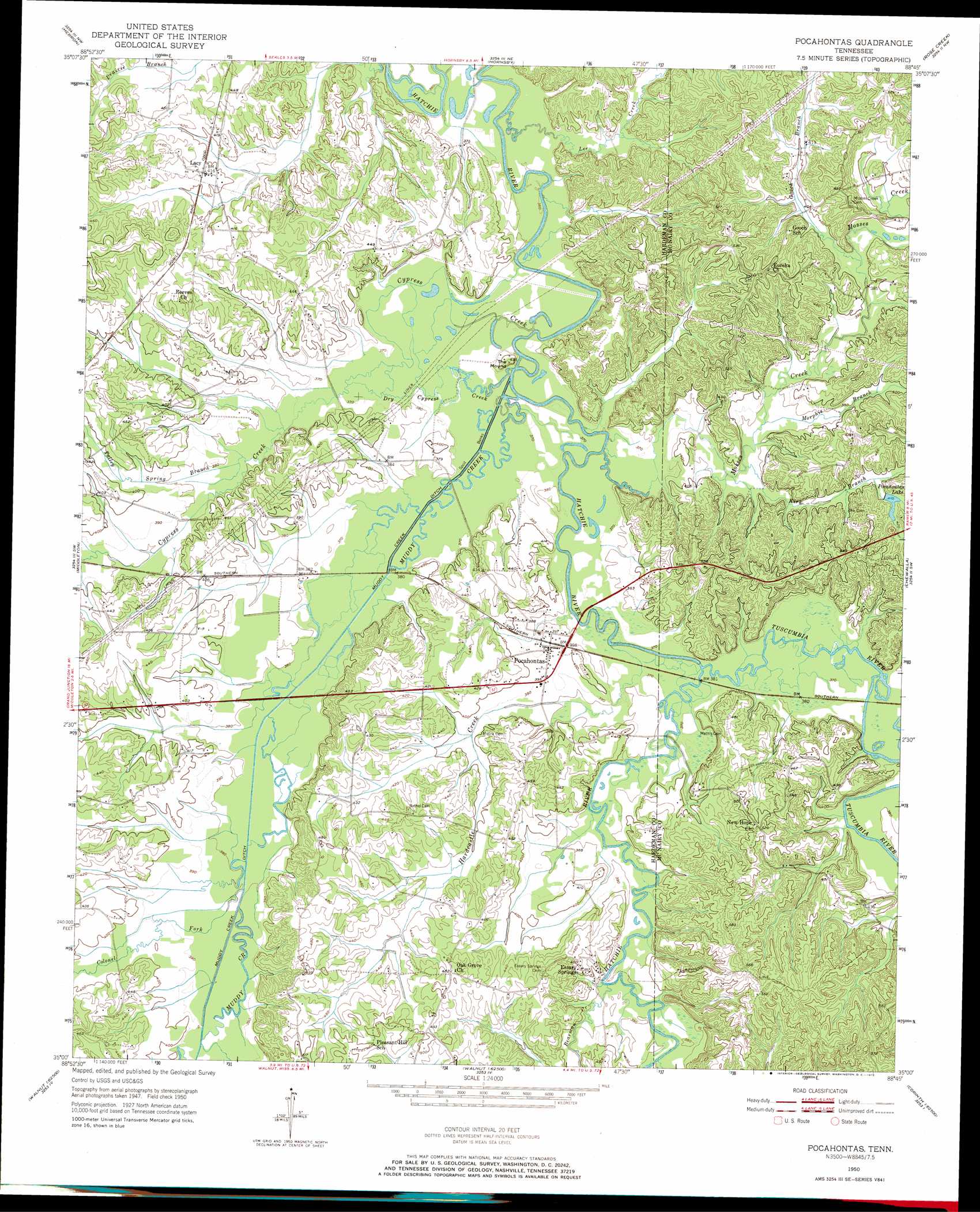
USGS Topo Quad 35088a7 - 1:24,000 scale
| Topo Map Name: | Pocahontas |
| USGS Topo Quad ID: | 35088a7 |
| Print Size: | ca. 21 1/4" wide x 27" high |
| Southeast Coordinates: | 35° N latitude / 88.75° W longitude |
| Map Center Coordinates: | 35.0625° N latitude / 88.8125° W longitude |
| U.S. State: | TN |
| Filename: | o35088a7.jpg |
| Download Map JPG Image: | Pocahontas topo map 1:24,000 scale |
| Map Type: | Topographic |
| Topo Series: | 7.5´ |
| Map Scale: | 1:24,000 |
| Source of Map Images: | United States Geological Survey (USGS) |
| Alternate Map Versions: |
Pocahontas TN 1950, updated 1972 Download PDF Buy paper map Pocahontas TN 1952 Download PDF Buy paper map Pocahontas TN 2010 Download PDF Buy paper map Pocahontas TN 2013 Download PDF Buy paper map Pocahontas TN 2016 Download PDF Buy paper map |
1:24,000 Topo Quads surrounding Pocahontas
Bolivar West |
Bolivar East |
Silerton |
Masseyville |
Mount Peter |
Middleburg |
Hebron |
Hornsby |
Rose Creek |
Purdy |
Saulsbury |
Middleton |
Pocahontas |
Chewalla |
Guys |
Camp Hill |
Walnut |
Chalybeate |
Kossuth North |
Corinth |
Whitten Town |
Falkner |
Peoples |
Kossuth South |
Rienzi |
> Back to 35088a1 at 1:100,000 scale
> Back to 35088a1 at 1:250,000 scale
> Back to U.S. Topo Maps home
Pocahontas topo map: Gazetteer
Pocahontas: Canals
Muddy Creek Ditch elevation 113m 370′Pocahontas: Dams
Muddy Creek Number Twenty-one Lake Dam elevation 122m 400′Pocahontas Dam elevation 125m 410′
Pocahontas: Populated Places
Essary Springs elevation 129m 423′Lacy elevation 127m 416′
Pocahontas elevation 120m 393′
Pocahontas: Reservoirs
Muddy Creek Lake Number Twenty-one elevation 122m 400′Pocahontas Lake elevation 125m 410′
Pocahontas: Streams
Bearman Creek elevation 113m 370′Bearman Creek elevation 113m 370′
Colonel Fork elevation 116m 380′
Cypress Creek elevation 110m 360′
Dry Cypress Creek elevation 110m 360′
Gooch Branch elevation 116m 380′
Hardcastle Creek elevation 110m 360′
Kirk Branch elevation 113m 370′
Lee Creek elevation 110m 360′
Morphis Branch elevation 114m 374′
Mosses Creek elevation 110m 360′
Muddy Creek elevation 110m 360′
Muddy Creek elevation 110m 360′
Talley Spring Branch elevation 114m 374′
Tuscumbia River elevation 110m 360′
Pocahontas: Summits
The Mound elevation 130m 426′Pocahontas digital topo map on disk
Buy this Pocahontas topo map showing relief, roads, GPS coordinates and other geographical features, as a high-resolution digital map file on DVD: