Savannah Topo Map Tennessee
To zoom in, hover over the map of Savannah
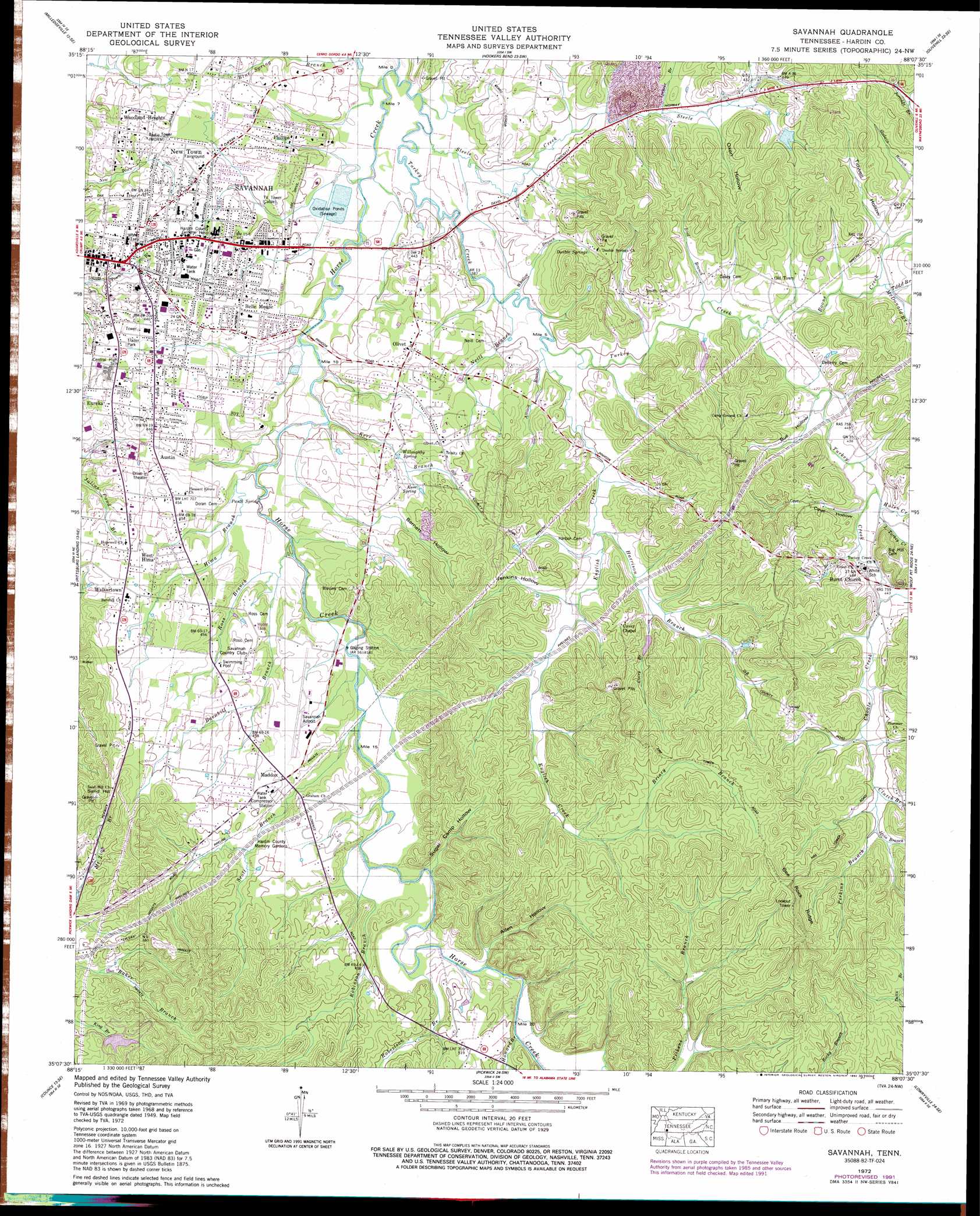
USGS Topo Quad 35088b2 - 1:24,000 scale
| Topo Map Name: | Savannah |
| USGS Topo Quad ID: | 35088b2 |
| Print Size: | ca. 21 1/4" wide x 27" high |
| Southeast Coordinates: | 35.125° N latitude / 88.125° W longitude |
| Map Center Coordinates: | 35.1875° N latitude / 88.1875° W longitude |
| U.S. State: | TN |
| Filename: | o35088b2.jpg |
| Download Map JPG Image: | Savannah topo map 1:24,000 scale |
| Map Type: | Topographic |
| Topo Series: | 7.5´ |
| Map Scale: | 1:24,000 |
| Source of Map Images: | United States Geological Survey (USGS) |
| Alternate Map Versions: |
Savannah TN 1936 Download PDF Buy paper map Savannah TN 1949, updated 1952 Download PDF Buy paper map Savannah TN 1972, updated 1974 Download PDF Buy paper map Savannah TN 1972, updated 1992 Download PDF Buy paper map Savannah TN 2010 Download PDF Buy paper map Savannah TN 2013 Download PDF Buy paper map Savannah TN 2016 Download PDF Buy paper map |
1:24,000 Topo Quads surrounding Savannah
Enville |
Sardis |
Thurman |
Bath Springs |
Clifton |
Leapwood |
Milledgeville |
Hookers Bend |
Olivehill |
Eagle Creek |
Stantonville |
Pittsburg Landing |
Savannah |
Wolf Pit Ridge |
Martins Mills |
Michie |
Counce |
Pickwick |
Lowryville |
Ransom Stand |
Kendrick |
Doskie |
Yellow Creek |
Waterloo |
Wright |
> Back to 35088a1 at 1:100,000 scale
> Back to 35088a1 at 1:250,000 scale
> Back to U.S. Topo Maps home
Savannah topo map: Gazetteer
Savannah: Airports
Savannah-Hardin County Airport elevation 142m 465′Savannah: Dams
Don Coleman Dam elevation 141m 462′Timberline Estates Dam elevation 155m 508′
Savannah: Parks
Savannah Historic District elevation 136m 446′Savannah: Populated Places
Austin elevation 132m 433′Belle Meade elevation 132m 433′
Economy (historical) elevation 117m 383′
Maddox elevation 145m 475′
New Town elevation 126m 413′
Olivet elevation 141m 462′
Phillips elevation 132m 433′
Savannah elevation 135m 442′
Walkertown elevation 144m 472′
West Hima elevation 141m 462′
Woodland Heights elevation 134m 439′
Savannah: Reservoirs
Don Coleman Lake elevation 141m 462′Timberline Estates Lake elevation 155m 508′
Savannah: Ridges
Bee Rock Ridge elevation 236m 774′Savannah: Springs
Double Springs elevation 139m 456′Kerr Spring elevation 134m 439′
Paulk Spring elevation 126m 413′
Willoughby Spring elevation 133m 436′
Savannah: Streams
Adams Branch elevation 131m 429′Allison Branch elevation 119m 390′
Barnhill Branch elevation 123m 403′
Bird Branch elevation 124m 406′
Boon Creek elevation 125m 410′
Briary Branch elevation 164m 538′
Casteal Branch elevation 132m 433′
Chimney Branch elevation 132m 433′
Choate Creek elevation 133m 436′
Clutch Branch elevation 148m 485′
Covey Branch elevation 130m 426′
English Creek elevation 119m 390′
Harrison Branch elevation 124m 406′
Hima Branch elevation 122m 400′
Howard Branch elevation 133m 436′
Hulen Creek elevation 132m 433′
Irvin Branch elevation 152m 498′
Kerr Branch elevation 120m 393′
Little Turkey Creek elevation 130m 426′
McDonald Branch elevation 132m 433′
Neill Branch elevation 117m 383′
Perkins Branch elevation 151m 495′
Robertson Branch elevation 130m 426′
Robinson Branch elevation 126m 413′
Ross Branch elevation 122m 400′
Scott Branch elevation 123m 403′
Spencer Branch elevation 125m 410′
Steele Creek elevation 114m 374′
Todd Branch elevation 133m 436′
Turkey Creek elevation 114m 374′
Whitlow Branch elevation 117m 383′
Savannah: Summits
Sand Hill elevation 196m 643′Savannah: Valleys
Allen Hollow elevation 134m 439′Barnett Hollow elevation 137m 449′
Bull Hollow elevation 128m 419′
Cave Hollow elevation 132m 433′
Godwin Mill Hollow elevation 126m 413′
Jenkins Hollow elevation 131m 429′
Mozier Mill Hollow elevation 133m 436′
Oxen Hollow elevation 157m 515′
Sugar Camp Hollow elevation 128m 419′
Tidwell Hollow elevation 133m 436′
Savannah digital topo map on disk
Buy this Savannah topo map showing relief, roads, GPS coordinates and other geographical features, as a high-resolution digital map file on DVD: