Pittsburg Landing Topo Map Tennessee
To zoom in, hover over the map of Pittsburg Landing
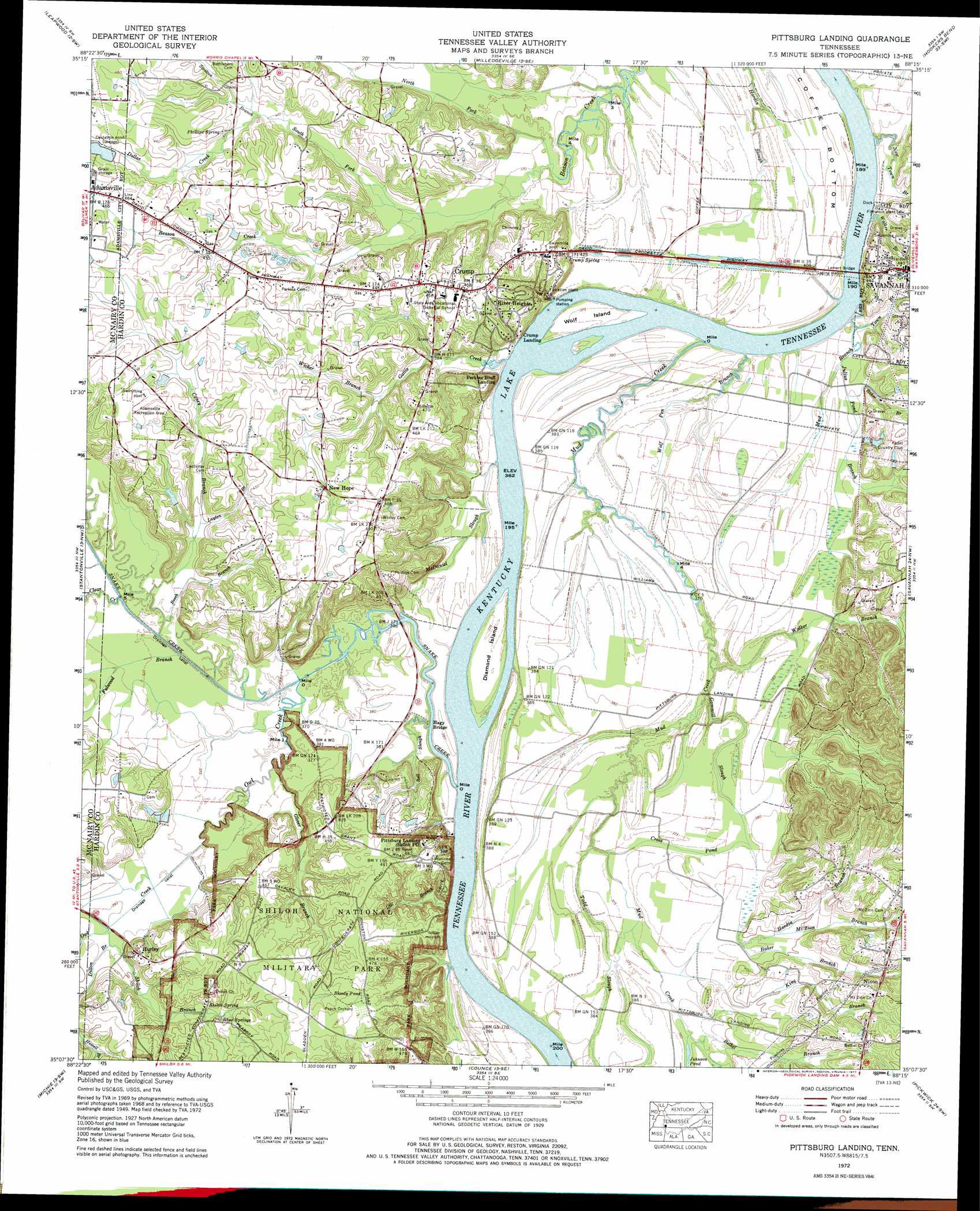
USGS Topo Quad 35088b3 - 1:24,000 scale
| Topo Map Name: | Pittsburg Landing |
| USGS Topo Quad ID: | 35088b3 |
| Print Size: | ca. 21 1/4" wide x 27" high |
| Southeast Coordinates: | 35.125° N latitude / 88.25° W longitude |
| Map Center Coordinates: | 35.1875° N latitude / 88.3125° W longitude |
| U.S. State: | TN |
| Filename: | o35088b3.jpg |
| Download Map JPG Image: | Pittsburg Landing topo map 1:24,000 scale |
| Map Type: | Topographic |
| Topo Series: | 7.5´ |
| Map Scale: | 1:24,000 |
| Source of Map Images: | United States Geological Survey (USGS) |
| Alternate Map Versions: |
Pittsburg Landing TN 1936 Download PDF Buy paper map Pittsburg Landing TN 1949, updated 1952 Download PDF Buy paper map Pittsburg Landing TN 1972, updated 1974 Download PDF Buy paper map Pittsburg Landing TN 1972, updated 1977 Download PDF Buy paper map Pittsburg Landing TN 2010 Download PDF Buy paper map Pittsburg Landing TN 2013 Download PDF Buy paper map Pittsburg Landing TN 2016 Download PDF Buy paper map |
1:24,000 Topo Quads surrounding Pittsburg Landing
Jacks Creek |
Enville |
Sardis |
Thurman |
Bath Springs |
Mount Peter |
Leapwood |
Milledgeville |
Hookers Bend |
Olivehill |
Purdy |
Stantonville |
Pittsburg Landing |
Savannah |
Wolf Pit Ridge |
Guys |
Michie |
Counce |
Pickwick |
Lowryville |
Corinth |
Kendrick |
Doskie |
Yellow Creek |
Waterloo |
> Back to 35088a1 at 1:100,000 scale
> Back to 35088a1 at 1:250,000 scale
> Back to U.S. Topo Maps home
Pittsburg Landing topo map: Gazetteer
Pittsburg Landing: Bars
Diamond Shoals elevation 110m 360′Pittsburg Landing: Bends
Coffee Bottom elevation 116m 380′Pittsburg Landing: Bridges
Lemert Bridge elevation 110m 360′Pittsburg Landing: Canals
Snake Creek Canal elevation 111m 364′Pittsburg Landing: Crossings
Browns Ferry (historical) elevation 110m 360′Pittsburg Landing Ferry (historical) elevation 110m 360′
Savannah Ferry (historical) elevation 110m 360′
Pittsburg Landing: Guts
Bell Slough elevation 110m 360′Pittsburg Landing: Islands
Diamond Island elevation 114m 374′Wolf Island elevation 114m 374′
Pittsburg Landing: Lakes
Bloody Pond elevation 150m 492′Johnson Pond elevation 115m 377′
Water Oaks Pond elevation 146m 479′
Pittsburg Landing: Parks
Adamsville Recreation Area elevation 141m 462′Riverside City Park elevation 127m 416′
Shiloh National Military Park elevation 138m 452′
Pittsburg Landing: Populated Places
Crump elevation 139m 456′Hurley elevation 139m 456′
New Hope elevation 137m 449′
Pittsburg Landing elevation 144m 472′
River Heights elevation 130m 426′
Pittsburg Landing: Springs
Crump Spring elevation 117m 383′Phillips Spring elevation 135m 442′
Rhea Springs elevation 136m 446′
Shiloh Spring elevation 131m 429′
Pittsburg Landing: Streams
Baker Branch elevation 112m 367′Baker Branch elevation 117m 383′
Beech Branch elevation 112m 367′
Bethel Branch elevation 114m 374′
Caney Branch elevation 111m 364′
Clear Creek elevation 111m 364′
Cross Pond elevation 113m 370′
Dill Branch elevation 114m 374′
Dillon Branch elevation 117m 383′
Dollar Creek elevation 126m 413′
Fulwood Branch elevation 111m 364′
Gammill Slough elevation 111m 364′
Gattis Creek elevation 110m 360′
Glover Branch elevation 112m 367′
Hardin Branch elevation 117m 383′
Julius Pond Branch elevation 112m 367′
King Branch elevation 114m 374′
Layton Branch elevation 120m 393′
McDaniel Slough elevation 110m 360′
Mount Zion Branch elevation 120m 393′
Mud Branch elevation 110m 360′
Mud Creek elevation 110m 360′
New Town Branch elevation 113m 370′
North Fork Beason Creek elevation 111m 364′
Owl Creek elevation 111m 364′
Riding Switch Slough elevation 112m 367′
Shiloh Branch elevation 119m 390′
Snake Creek elevation 110m 360′
South Fork Beason Creek elevation 113m 370′
Stratton Branch elevation 126m 413′
Todd Slough elevation 113m 370′
Town Branch elevation 112m 367′
Walker Branch elevation 110m 360′
Walker Branch elevation 111m 364′
Wicker Branch elevation 121m 396′
Williams Slough elevation 113m 370′
Wolf Pen Branch elevation 110m 360′
Pittsburg Landing digital topo map on disk
Buy this Pittsburg Landing topo map showing relief, roads, GPS coordinates and other geographical features, as a high-resolution digital map file on DVD: