Bath Springs Topo Map Tennessee
To zoom in, hover over the map of Bath Springs
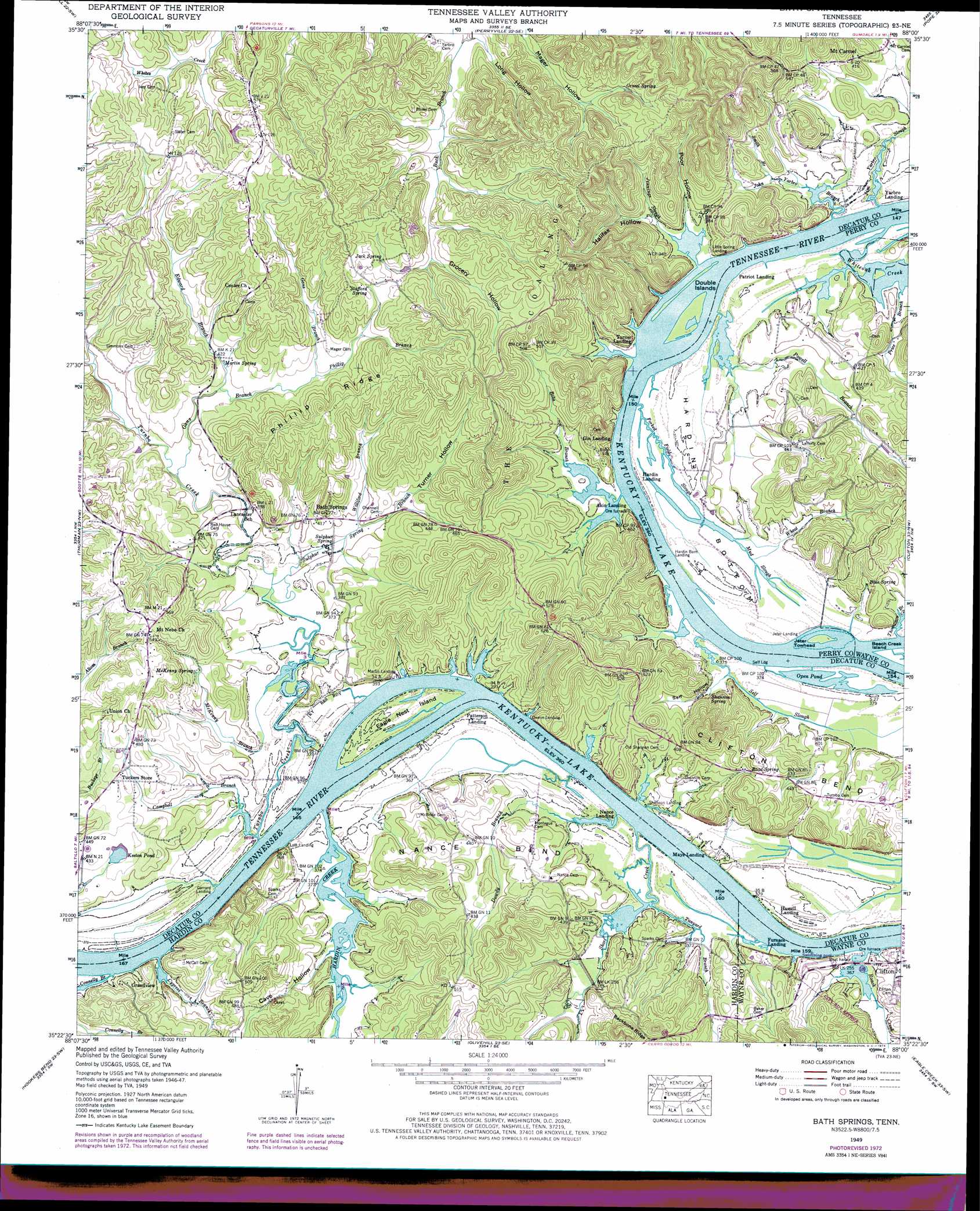
USGS Topo Quad 35088d1 - 1:24,000 scale
| Topo Map Name: | Bath Springs |
| USGS Topo Quad ID: | 35088d1 |
| Print Size: | ca. 21 1/4" wide x 27" high |
| Southeast Coordinates: | 35.375° N latitude / 88° W longitude |
| Map Center Coordinates: | 35.4375° N latitude / 88.0625° W longitude |
| U.S. State: | TN |
| Filename: | o35088d1.jpg |
| Download Map JPG Image: | Bath Springs topo map 1:24,000 scale |
| Map Type: | Topographic |
| Topo Series: | 7.5´ |
| Map Scale: | 1:24,000 |
| Source of Map Images: | United States Geological Survey (USGS) |
| Alternate Map Versions: |
Bath Springs TN 1936 Download PDF Buy paper map Bath Springs TN 1949, updated 1952 Download PDF Buy paper map Bath Springs TN 1949, updated 1973 Download PDF Buy paper map Bath Springs TN 2010 Download PDF Buy paper map Bath Springs TN 2013 Download PDF Buy paper map Bath Springs TN 2016 Download PDF Buy paper map |
1:24,000 Topo Quads surrounding Bath Springs
Chesterfield |
Parsons |
Jeanette |
Pine View |
Chestnut Grove |
Reagan |
Scotts Hill |
Perryville |
Pope |
Linden |
Sardis |
Thurman |
Bath Springs |
Clifton |
Leatherwood |
Milledgeville |
Hookers Bend |
Olivehill |
Eagle Creek |
Waynesboro |
Pittsburg Landing |
Savannah |
Wolf Pit Ridge |
Martins Mills |
Three Churches |
> Back to 35088a1 at 1:100,000 scale
> Back to 35088a1 at 1:250,000 scale
> Back to U.S. Topo Maps home
Bath Springs topo map: Gazetteer
Bath Springs: Bars
Buffalo Shoals elevation 109m 357′Roches Bar elevation 109m 357′
Bath Springs: Bends
Clifton Bend elevation 128m 419′Hardin Bottom elevation 122m 400′
Nance Bend elevation 122m 400′
Bath Springs: Crossings
Borough Ford (historical) elevation 112m 367′James Ferry (historical) elevation 109m 357′
Bath Springs: Islands
Double Islands elevation 110m 360′Eagle Nest Island elevation 113m 370′
Jeter Towhead elevation 110m 360′
Bath Springs: Lakes
Open Pond elevation 110m 360′Bath Springs: Populated Places
Bath Springs elevation 127m 416′Grandview elevation 134m 439′
Mount Carmel elevation 125m 410′
Bath Springs: Post Offices
Bath Springs Post Office elevation 127m 416′Bath Springs: Reservoirs
Keeton Pond elevation 126m 413′Bath Springs: Ridges
Phillip Ridge elevation 177m 580′Bath Springs: Springs
Blue Spring elevation 116m 380′Gravel Spring elevation 151m 495′
Jack Spring elevation 158m 518′
Little Spring elevation 109m 357′
Martin Spring elevation 128m 419′
McKenny Spring elevation 129m 423′
Road Spring elevation 141m 462′
Shannon Spring elevation 114m 374′
Stafford Spring elevation 158m 518′
Sulphur Spring elevation 116m 380′
Bath Springs: Streams
Altom Branch elevation 113m 370′Bobs Branch elevation 109m 357′
Butler Branch elevation 119m 390′
Campbell Branch elevation 111m 364′
Connelly Branch elevation 109m 357′
Cypress Branch elevation 109m 357′
Dowdy Branch elevation 109m 357′
Edward Branch elevation 122m 400′
Forked Field Slough elevation 110m 360′
Gans Branch elevation 116m 380′
Hardin Creek elevation 111m 364′
Jennings Slough elevation 110m 360′
Jim Yarbro Slough elevation 109m 357′
John Yarbro Branch elevation 112m 367′
McKenny Branch elevation 113m 370′
Mud Slough elevation 112m 367′
Phillip Branch elevation 132m 433′
Powell Branch elevation 110m 360′
Price Branch elevation 110m 360′
Roach Creek elevation 109m 357′
Self Slough elevation 111m 364′
Short Creek elevation 109m 357′
Smith Branch elevation 116m 380′
Sulphur Branch elevation 113m 370′
Tanyard Branch elevation 114m 374′
Thompson Branch elevation 111m 364′
Turnbo Creek elevation 110m 360′
Wheat Branch elevation 113m 370′
Whiteoak Creek elevation 109m 357′
Williford Branch elevation 117m 383′
Bath Springs: Valleys
Cave Hollow elevation 114m 374′Grocery Hollow elevation 144m 472′
Halifax Hollow elevation 116m 380′
Hughes Hollow elevation 109m 357′
Long Hollow elevation 126m 413′
Poor Hollow elevation 110m 360′
Self Hollow elevation 113m 370′
Turner Hollow elevation 120m 393′
Bath Springs digital topo map on disk
Buy this Bath Springs topo map showing relief, roads, GPS coordinates and other geographical features, as a high-resolution digital map file on DVD: