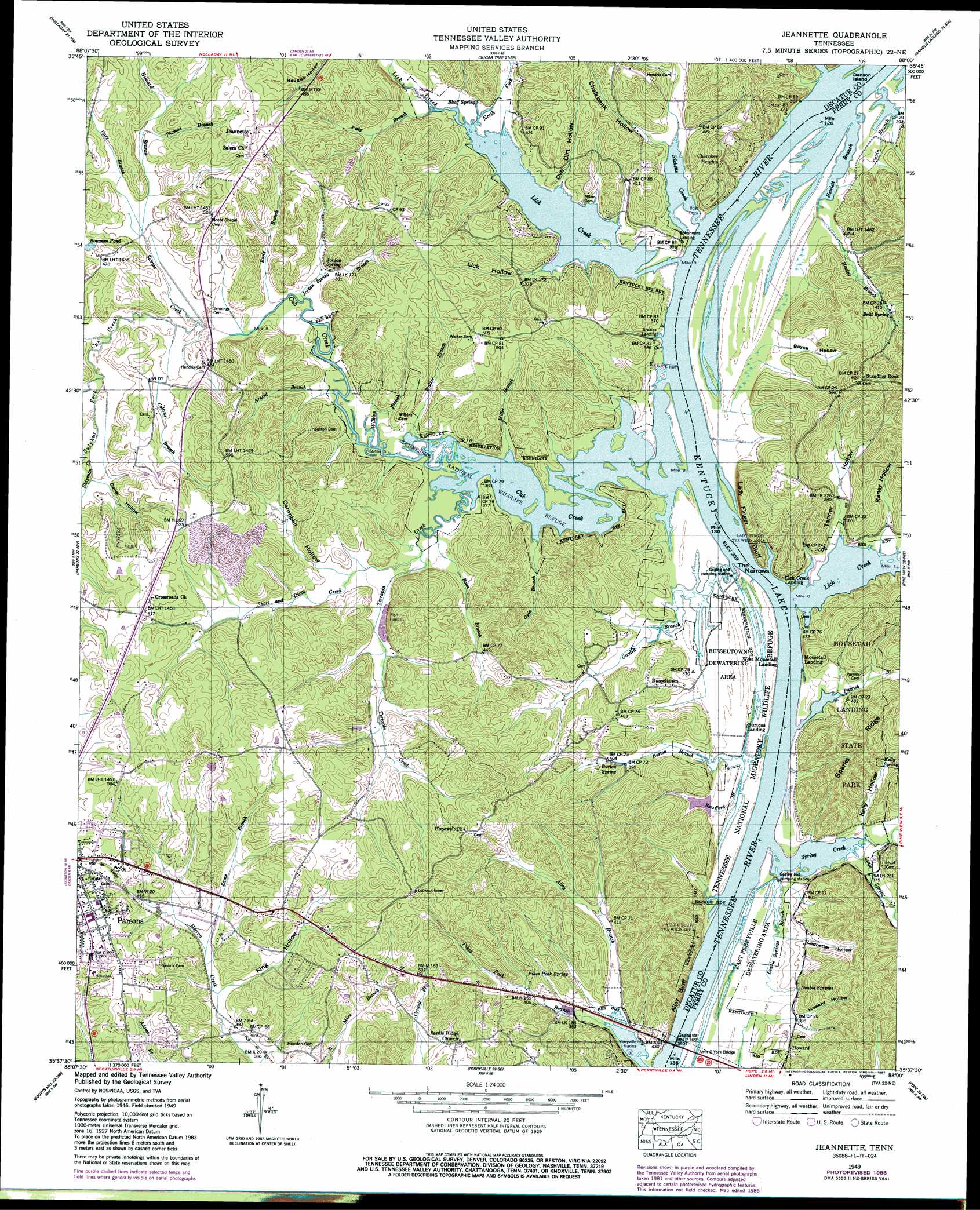
Jeanette Topo Map Tennessee
To zoom in, hover over the map of Jeanette
USGS Topo Quad 35088f1 - 1:24,000 scale
| Topo Map Name: | Jeanette |
| USGS Topo Quad ID: | 35088f1 |
| Print Size: | ca. 21 1/4" wide x 27" high |
| Southeast Coordinates: | 35.625° N latitude / 88° W longitude |
| Map Center Coordinates: | 35.6875° N latitude / 88.0625° W longitude |
| U.S. State: | TN |
| Filename: | o35088f1.jpg |
| Download Map JPG Image: | Jeanette topo map 1:24,000 scale |
| Map Type: | Topographic |
| Topo Series: | 7.5´ |
| Map Scale: | 1:24,000 |
| Source of Map Images: | United States Geological Survey (USGS) |
| Alternate Map Versions: |
Jeannette TN 1936 Download PDF Buy paper map Jeannette TN 1949, updated 1953 Download PDF Buy paper map Jeannette TN 1949, updated 1987 Download PDF Buy paper map Jeannette TN 2010 Download PDF Buy paper map Jeannette TN 2013 Download PDF Buy paper map Jeannette TN 2016 Download PDF Buy paper map |
1:24,000 Topo Quads surrounding Jeanette
Buena Vista |
Seventeen Creek |
Rockport |
Hustburg |
Hurricane Mills |
Yuma |
Holladay |
Sugar Tree |
Daniels Landing |
Lobelville |
Chesterfield |
Parsons |
Jeanette |
Pine View |
Chestnut Grove |
Reagan |
Scotts Hill |
Perryville |
Pope |
Linden |
Sardis |
Thurman |
Bath Springs |
Clifton |
Leatherwood |
> Back to 35088e1 at 1:100,000 scale
> Back to 35088a1 at 1:250,000 scale
> Back to U.S. Topo Maps home
Jeanette topo map: Gazetteer
Jeanette: Basins
Busseltown Dewatering Area elevation 112m 367′East Perryville Dewatering Area elevation 110m 360′
Jeanette: Bridges
Alvin C York Bridge elevation 109m 357′Jeanette: Cliffs
Alley Bluff elevation 127m 416′Lady Finger Bluff elevation 125m 410′
Jeanette: Crossings
Brodies Ferry (historical) elevation 109m 357′Horseshoe Ford (historical) elevation 109m 357′
Houston Ford elevation 110m 360′
Jeanette: Flats
Bateman Bottom elevation 109m 357′Perryville Bottom elevation 113m 370′
Jeanette: Gaps
The Narrows elevation 109m 357′Jeanette: Islands
Denson Island elevation 110m 360′Jeanette: Lakes
Bowman Pond elevation 139m 456′Jeanette: Parks
Alley Bluff Tennessee Valley Authority Wild Area elevation 148m 485′Busseltown Unit Tennessee National Wildlife Refuge elevation 110m 360′
Mousetail Landing State Park elevation 141m 462′
Jeanette: Populated Places
Busseltown elevation 145m 475′Cherokee Heights elevation 143m 469′
Hopewell elevation 179m 587′
Howard elevation 128m 419′
Jeannette elevation 170m 557′
Mousetail (historical) elevation 109m 357′
Jeanette: Post Offices
Parker Post Office (historical) elevation 130m 426′Jeanette: Rapids
Mousetail Eddy elevation 109m 357′Jeanette: Springs
Bluff Spring elevation 113m 370′Britt Spring elevation 132m 433′
Burton Spring elevation 121m 396′
Double Springs elevation 120m 393′
Jordan Spring elevation 115m 377′
Kelly Spring elevation 134m 439′
Pikes Peak Spring elevation 131m 429′
Jeanette: Streams
Alley Branch elevation 114m 374′Arnold Branch elevation 110m 360′
Bates Branch elevation 110m 360′
Booty Branch elevation 110m 360′
Burton Branch elevation 109m 357′
Cabin Branch elevation 109m 357′
Collins Branch elevation 113m 370′
Cub Creek elevation 109m 357′
Dare Branch elevation 116m 380′
Double Springs Branch elevation 109m 357′
Goodin Branch elevation 110m 360′
Guin Branch elevation 109m 357′
Hewlett Branch elevation 109m 357′
Hilliard Branch elevation 116m 380′
Horny Head Creek elevation 113m 370′
Jordan Spring Branch elevation 110m 360′
Lick Creek elevation 109m 357′
Lick Creek elevation 109m 357′
Little Spring Creek elevation 110m 360′
Miller Branch elevation 109m 357′
North Fork Lick Creek elevation 109m 357′
Parrish Branch elevation 109m 357′
Petty Branch elevation 110m 360′
Rains Branch elevation 121m 396′
Ricketts Creek elevation 109m 357′
Short and Dirty Creek elevation 111m 364′
Spring Creek elevation 109m 357′
Storms Creek elevation 113m 370′
Sulphur Fork Cub Creek elevation 113m 370′
Swafford Branch elevation 109m 357′
Terrapin Creek elevation 109m 357′
Thomas Branch elevation 121m 396′
Walker Branch elevation 110m 360′
Wilkins Branch elevation 110m 360′
Jeanette: Valleys
Boyce Hollow elevation 113m 370′Campbell Hollow elevation 117m 383′
Chalkbank Hollow elevation 112m 367′
Dailey Hollow elevation 119m 390′
Dye Dirt Hollow elevation 111m 364′
Howard Hollow elevation 121m 396′
Kelly Hollow elevation 112m 367′
King Hollow elevation 118m 387′
Ledbetter Hollow elevation 117m 383′
Lick Hollow elevation 109m 357′
Raney Hollow elevation 114m 374′
Tanner Hollow elevation 109m 357′
Jeanette digital topo map on disk
Buy this Jeanette topo map showing relief, roads, GPS coordinates and other geographical features, as a high-resolution digital map file on DVD: