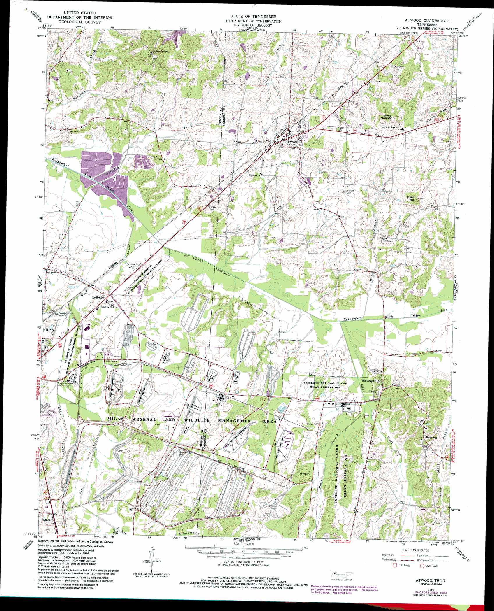
Atwood Topo Map Tennessee
To zoom in, hover over the map of Atwood
USGS Topo Quad 35088h6 - 1:24,000 scale
| Topo Map Name: | Atwood |
| USGS Topo Quad ID: | 35088h6 |
| Print Size: | ca. 21 1/4" wide x 27" high |
| Southeast Coordinates: | 35.875° N latitude / 88.625° W longitude |
| Map Center Coordinates: | 35.9375° N latitude / 88.6875° W longitude |
| U.S. State: | TN |
| Filename: | o35088h6.jpg |
| Download Map JPG Image: | Atwood topo map 1:24,000 scale |
| Map Type: | Topographic |
| Topo Series: | 7.5´ |
| Map Scale: | 1:24,000 |
| Source of Map Images: | United States Geological Survey (USGS) |
| Alternate Map Versions: |
Atwood TN 1966, updated 1967 Download PDF Buy paper map Atwood TN 1966, updated 1979 Download PDF Buy paper map Atwood TN 1966, updated 1983 Download PDF Buy paper map Atwood TN 1966, updated 1983 Download PDF Buy paper map Atwood TN 2010 Download PDF Buy paper map Atwood TN 2013 Download PDF Buy paper map Atwood TN 2016 Download PDF Buy paper map |
1:24,000 Topo Quads surrounding Atwood
Rutherford |
Greenfield |
Pillowville |
Mckenzie |
Henry |
Dyer |
Bradford |
Trezevant West |
Trezevant East |
Huntingdon |
Trenton |
Milan |
Atwood |
Mclemoresville |
Palmer Shelter |
Humboldt |
Medina |
Spring Creek |
Cedar Grove |
Clarksburg |
Adair |
Jackson North |
Claybrook |
Juno |
Lexington |
> Back to 35088e1 at 1:100,000 scale
> Back to 35088a1 at 1:250,000 scale
> Back to U.S. Topo Maps home
Atwood topo map: Gazetteer
Atwood: Dams
Creswell Lake Number Thirty-eight Dam elevation 110m 360′Creswell Lake Number Thirty-five Dam elevation 110m 360′
Creswell Lake Number Thirty-four Dam elevation 110m 360′
Creswell Lake Number Thirty-one Dam elevation 110m 360′
Creswell Lake Number Thirty-three Dam elevation 110m 360′
Creswell Lake Number Thirty-two Dam elevation 110m 360′
Creswell Lake Number Twenty-eight Dam elevation 110m 360′
Creswell Lake Number Twenty-five Dam elevation 110m 360′
Creswell Lake Number Twenty-four Dam elevation 110m 360′
Creswell Lake Number Twenty-nine Dam elevation 110m 360′
Creswell Lake Number Twenty-one Dam elevation 110m 360′
Creswell Lake Number Twenty-three Dam elevation 110m 360′
Luckey Lake Dam elevation 124m 406′
Atwood: Parks
Milan City Park elevation 125m 410′Rotary Field elevation 124m 406′
Atwood: Populated Places
Atwood elevation 135m 442′Hopewell elevation 154m 505′
Howse elevation 143m 469′
Ledbetter elevation 123m 403′
New Hope (historical) elevation 122m 400′
Whitthorne elevation 131m 429′
Atwood: Reservoirs
Creswell Lake Number Thirty-eight elevation 110m 360′Creswell Lake Number Thirty-five elevation 110m 360′
Creswell Lake Number Thirty-four elevation 110m 360′
Creswell Lake Number Thirty-one elevation 110m 360′
Creswell Lake Number Thirty-three elevation 110m 360′
Creswell Lake Number Thirty-two elevation 110m 360′
Creswell Lake Number Twenty-eight elevation 110m 360′
Creswell Lake Number Twenty-five elevation 110m 360′
Creswell Lake Number Twenty-four elevation 110m 360′
Creswell Lake Number Twenty-nine elevation 110m 360′
Creswell Lake Number Twenty-one elevation 110m 360′
Creswell Lake Number Twenty-three elevation 110m 360′
Luckey Lake elevation 124m 406′
Atwood: Streams
Clear Creek elevation 118m 387′Cressville Creek elevation 110m 360′
East Fork Wolf Creek elevation 128m 419′
Halls Branch elevation 119m 390′
Johns Creek elevation 114m 374′
Sandy Branch elevation 116m 380′
Steep Bank Branch elevation 119m 390′
West Fork Wolf Creek elevation 128m 419′
Wolf Creek elevation 111m 364′
Atwood: Summits
Clark Mountain elevation 175m 574′Webb Mountain elevation 183m 600′
Atwood digital topo map on disk
Buy this Atwood topo map showing relief, roads, GPS coordinates and other geographical features, as a high-resolution digital map file on DVD: