Grand Junction Topo Map Tennessee
To zoom in, hover over the map of Grand Junction
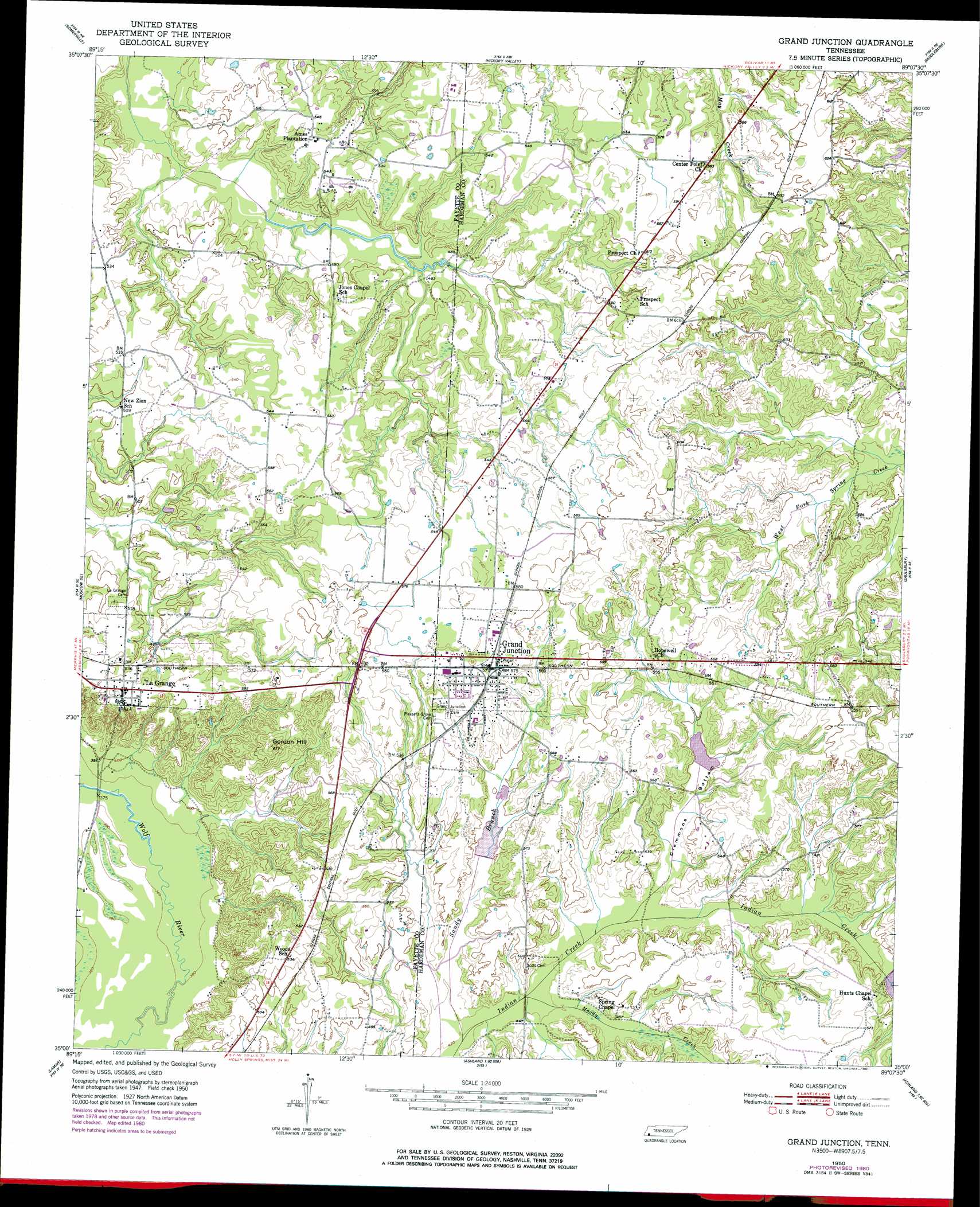
USGS Topo Quad 35089a2 - 1:24,000 scale
| Topo Map Name: | Grand Junction |
| USGS Topo Quad ID: | 35089a2 |
| Print Size: | ca. 21 1/4" wide x 27" high |
| Southeast Coordinates: | 35° N latitude / 89.125° W longitude |
| Map Center Coordinates: | 35.0625° N latitude / 89.1875° W longitude |
| U.S. State: | TN |
| Filename: | o35089a2.jpg |
| Download Map JPG Image: | Grand Junction topo map 1:24,000 scale |
| Map Type: | Topographic |
| Topo Series: | 7.5´ |
| Map Scale: | 1:24,000 |
| Source of Map Images: | United States Geological Survey (USGS) |
| Alternate Map Versions: |
Grand Junction TN 1950, updated 1981 Download PDF Buy paper map Grand Junction TN 1951 Download PDF Buy paper map Grand Junction TN 1951 Download PDF Buy paper map Grand Junction TN 2010 Download PDF Buy paper map Grand Junction TN 2013 Download PDF Buy paper map Grand Junction TN 2016 Download PDF Buy paper map |
1:24,000 Topo Quads surrounding Grand Junction
Lambert |
Laconia |
Whiteville |
Bolivar West |
Bolivar East |
Macon |
Somerville |
Hickory Valley |
Middleburg |
Hebron |
Moscow |
Moscow Se |
Grand Junction |
Saulsbury |
Middleton |
Slayden |
Lamar |
Canaan |
Camp Hill |
Walnut |
Holly Springs |
Holly Springs Se |
Ashland |
Whitten Town |
Falkner |
> Back to 35089a1 at 1:100,000 scale
> Back to 35088a1 at 1:250,000 scale
> Back to U.S. Topo Maps home
Grand Junction topo map: Gazetteer
Grand Junction: Dams
Indian Creek Watershed Number Four Dam elevation 150m 492′Indian Creek Watershed Number Seven Dam elevation 147m 482′
Indian Creek Watershed Number Two Dam elevation 144m 472′
Grand Junction: Populated Places
Center Point elevation 170m 557′Grand Junction elevation 174m 570′
La Grange elevation 169m 554′
Grand Junction: Reservoirs
Indian Creek Watershed Number Four Lake elevation 150m 492′Indian Creek Watershed Number Seven Lake elevation 147m 482′
Indian Creek Watershed Number Two Lake elevation 144m 472′
Grand Junction: Streams
Moody Creek elevation 133m 436′Moody Creek elevation 133m 436′
Grand Junction: Summits
Gordon Hill elevation 203m 666′Grand Junction: Valleys
Clemmons Bottom elevation 139m 456′Grand Junction digital topo map on disk
Buy this Grand Junction topo map showing relief, roads, GPS coordinates and other geographical features, as a high-resolution digital map file on DVD: