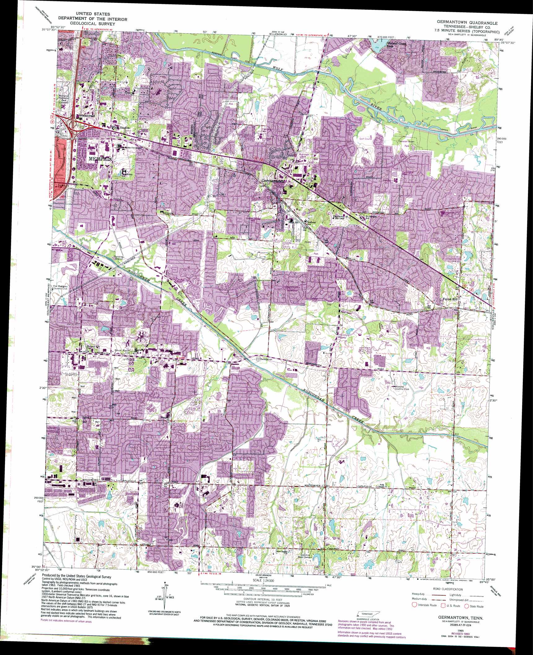
Germantown Topo Map Tennessee
To zoom in, hover over the map of Germantown
USGS Topo Quad 35089a7 - 1:24,000 scale
| Topo Map Name: | Germantown |
| USGS Topo Quad ID: | 35089a7 |
| Print Size: | ca. 21 1/4" wide x 27" high |
| Southeast Coordinates: | 35° N latitude / 89.75° W longitude |
| Map Center Coordinates: | 35.0625° N latitude / 89.8125° W longitude |
| U.S. State: | TN |
| Filename: | o35089a7.jpg |
| Download Map JPG Image: | Germantown topo map 1:24,000 scale |
| Map Type: | Topographic |
| Topo Series: | 7.5´ |
| Map Scale: | 1:24,000 |
| Source of Map Images: | United States Geological Survey (USGS) |
| Alternate Map Versions: |
Germantown TN 1965, updated 1967 Download PDF Buy paper map Germantown TN 1965, updated 1974 Download PDF Buy paper map Germantown TN 1965, updated 1984 Download PDF Buy paper map Germantown TN 1965, updated 1994 Download PDF Buy paper map Germantown TN 1997, updated 1999 Download PDF Buy paper map Germantown TN 2010 Download PDF Buy paper map Germantown TN 2013 Download PDF Buy paper map Germantown TN 2016 Download PDF Buy paper map |
1:24,000 Topo Quads surrounding Germantown
Locke |
Millington |
Brunswick |
Arlington |
Gallaway |
Northwest Memphis |
Northeast Memphis |
Ellendale |
Eads |
Oakland |
Southwest Memphis |
Southeast Memphis |
Germantown |
Collierville |
Rossville |
Horn Lake |
Pleasant Hill |
Olive Branch |
Byhalia Nw |
Mount Pleasant |
Frees Corners |
Hernando |
Lewisburg |
Byhalia |
Red Banks |
> Back to 35089a1 at 1:100,000 scale
> Back to 35088a1 at 1:250,000 scale
> Back to U.S. Topo Maps home
Germantown topo map: Gazetteer
Germantown: Crossings
Interchange 15 elevation 93m 305′Germantown: Dams
Glen Echo Lake Dam elevation 102m 334′Hamilton Lake Dam elevation 107m 351′
Hunt Lake Dam elevation 104m 341′
Jamieson Lake Dam elevation 110m 360′
Nolan Lake Dam elevation 94m 308′
Norfleet Turner Dam elevation 90m 295′
Old Optimist Boys Camp Lake Dam elevation 110m 360′
Walnut Grove Lake Dam elevation 91m 298′
Germantown: Parks
Cameron-Brown Park elevation 82m 269′Farmington Park elevation 85m 278′
Fox Meadows Park elevation 88m 288′
Franklin-Morgan Woods-Cloyes Park elevation 117m 383′
Hacks Cross Road Park elevation 117m 383′
Howard McVay Park elevation 103m 337′
Lichterman Park elevation 89m 291′
May Park elevation 85m 278′
Poplar Estates Parkway elevation 77m 252′
Riverdale Park elevation 89m 291′
Germantown: Populated Places
Bleak (historical) elevation 109m 357′Booth (historical) elevation 116m 380′
Forest Hill elevation 111m 364′
Germantown elevation 115m 377′
Greenlawn elevation 102m 334′
Irene (historical) elevation 108m 354′
River Oaks elevation 82m 269′
Southwind elevation 110m 360′
White Station elevation 101m 331′
Germantown: Post Offices
Forest Hill Post Office elevation 108m 354′Germantown Post Office elevation 94m 308′
Hickory Hill Post Office elevation 103m 337′
White Post Office elevation 98m 321′
Germantown: Reservoirs
Glen Echo Lake elevation 102m 334′Hamilton Lake elevation 107m 351′
Hunt Lake elevation 104m 341′
Jamieson Lake elevation 110m 360′
Nolan Lake elevation 94m 308′
Norfleet Turner Lake elevation 90m 295′
Old Optimist Boys Camp Lake elevation 110m 360′
Walnut Grove Lake elevation 91m 298′
Germantown digital topo map on disk
Buy this Germantown topo map showing relief, roads, GPS coordinates and other geographical features, as a high-resolution digital map file on DVD: