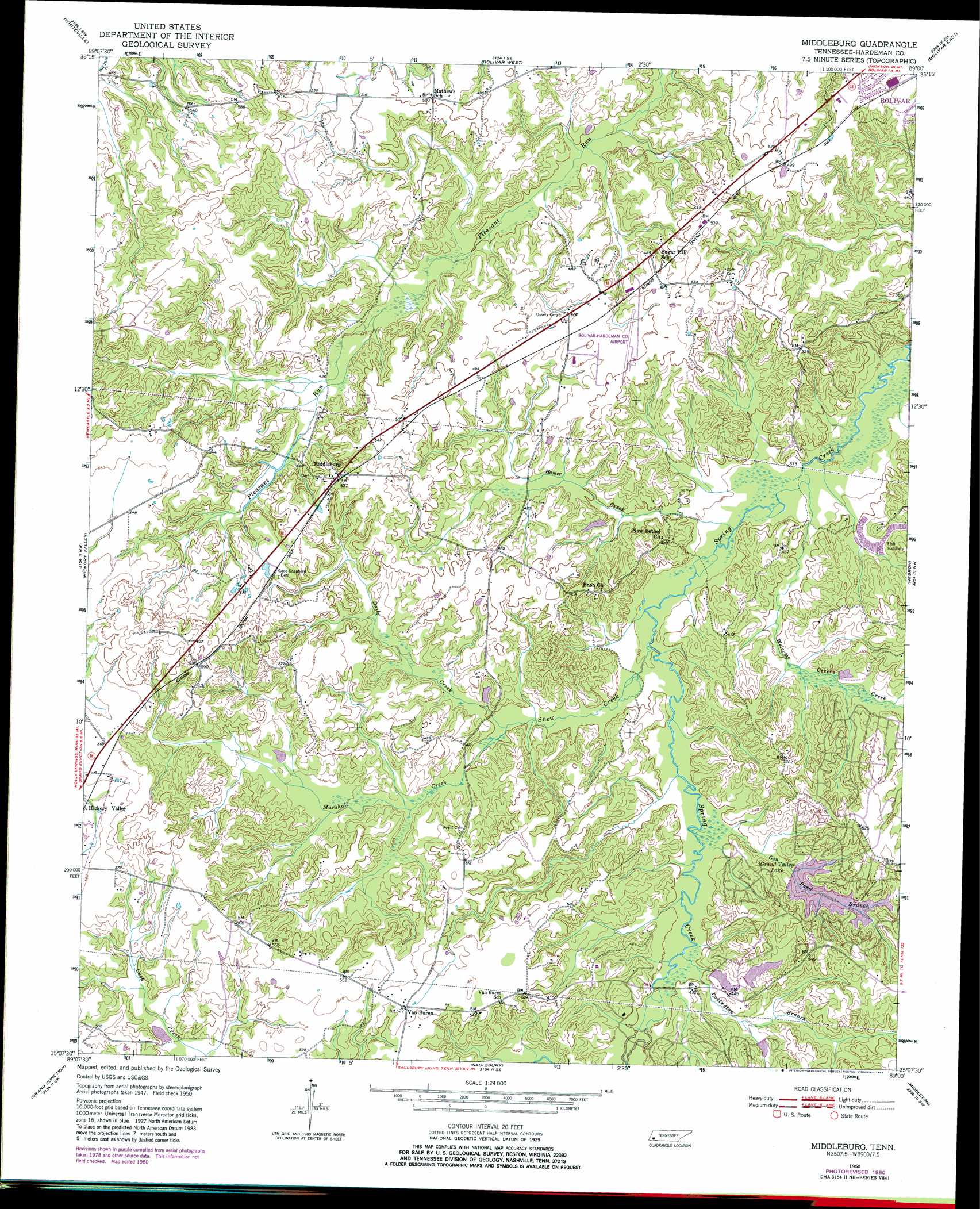
Middleburg Topo Map Tennessee
To zoom in, hover over the map of Middleburg
USGS Topo Quad 35089b1 - 1:24,000 scale
| Topo Map Name: | Middleburg |
| USGS Topo Quad ID: | 35089b1 |
| Print Size: | ca. 21 1/4" wide x 27" high |
| Southeast Coordinates: | 35.125° N latitude / 89° W longitude |
| Map Center Coordinates: | 35.1875° N latitude / 89.0625° W longitude |
| U.S. State: | TN |
| Filename: | o35089b1.jpg |
| Download Map JPG Image: | Middleburg topo map 1:24,000 scale |
| Map Type: | Topographic |
| Topo Series: | 7.5´ |
| Map Scale: | 1:24,000 |
| Source of Map Images: | United States Geological Survey (USGS) |
| Alternate Map Versions: |
Middleburg TN 1950, updated 1975 Download PDF Buy paper map Middleburg TN 1950, updated 1981 Download PDF Buy paper map Middleburg TN 1951 Download PDF Buy paper map Middleburg TN 2010 Download PDF Buy paper map Middleburg TN 2013 Download PDF Buy paper map Middleburg TN 2016 Download PDF Buy paper map |
1:24,000 Topo Quads surrounding Middleburg
Dancyville |
Hillville |
Mercer |
Teague |
Medon |
Laconia |
Whiteville |
Bolivar West |
Bolivar East |
Silerton |
Somerville |
Hickory Valley |
Middleburg |
Hebron |
Hornsby |
Moscow Se |
Grand Junction |
Saulsbury |
Middleton |
Pocahontas |
Lamar |
Canaan |
Camp Hill |
Walnut |
Chalybeate |
> Back to 35089a1 at 1:100,000 scale
> Back to 35088a1 at 1:250,000 scale
> Back to U.S. Topo Maps home
Middleburg topo map: Gazetteer
Middleburg: Airports
Bolivar-Hardeman County Airport elevation 150m 492′Middleburg: Dams
Grand Valley Dam Number Two elevation 143m 469′Grand Valley Lake Number One Dam elevation 137m 449′
Spring Creek Ranch Lake Number One Dam elevation 121m 396′
Spring Creek Ranch Lake Number Two Dam elevation 141m 462′
Middleburg: Populated Places
Middleburg elevation 164m 538′Sugar Hill elevation 152m 498′
Van Buren elevation 160m 524′
Middleburg: Reservoirs
Grand Valley Lake elevation 137m 449′Grand Valley Lake Number Two elevation 143m 469′
Spring Creek Ranch Lake Number One elevation 121m 396′
Spring Creek Ranch Lake Number Two elevation 141m 462′
Middleburg: Streams
Covington Branch elevation 118m 387′Daily Creek elevation 119m 390′
Gin Pond Branch elevation 121m 396′
Hamer Creek elevation 113m 370′
Marshall Creek elevation 119m 390′
Snow Creek elevation 115m 377′
Welcome Ussery Creek elevation 114m 374′
Middleburg digital topo map on disk
Buy this Middleburg topo map showing relief, roads, GPS coordinates and other geographical features, as a high-resolution digital map file on DVD: