Northeast Memphis Topo Map Tennessee
To zoom in, hover over the map of Northeast Memphis
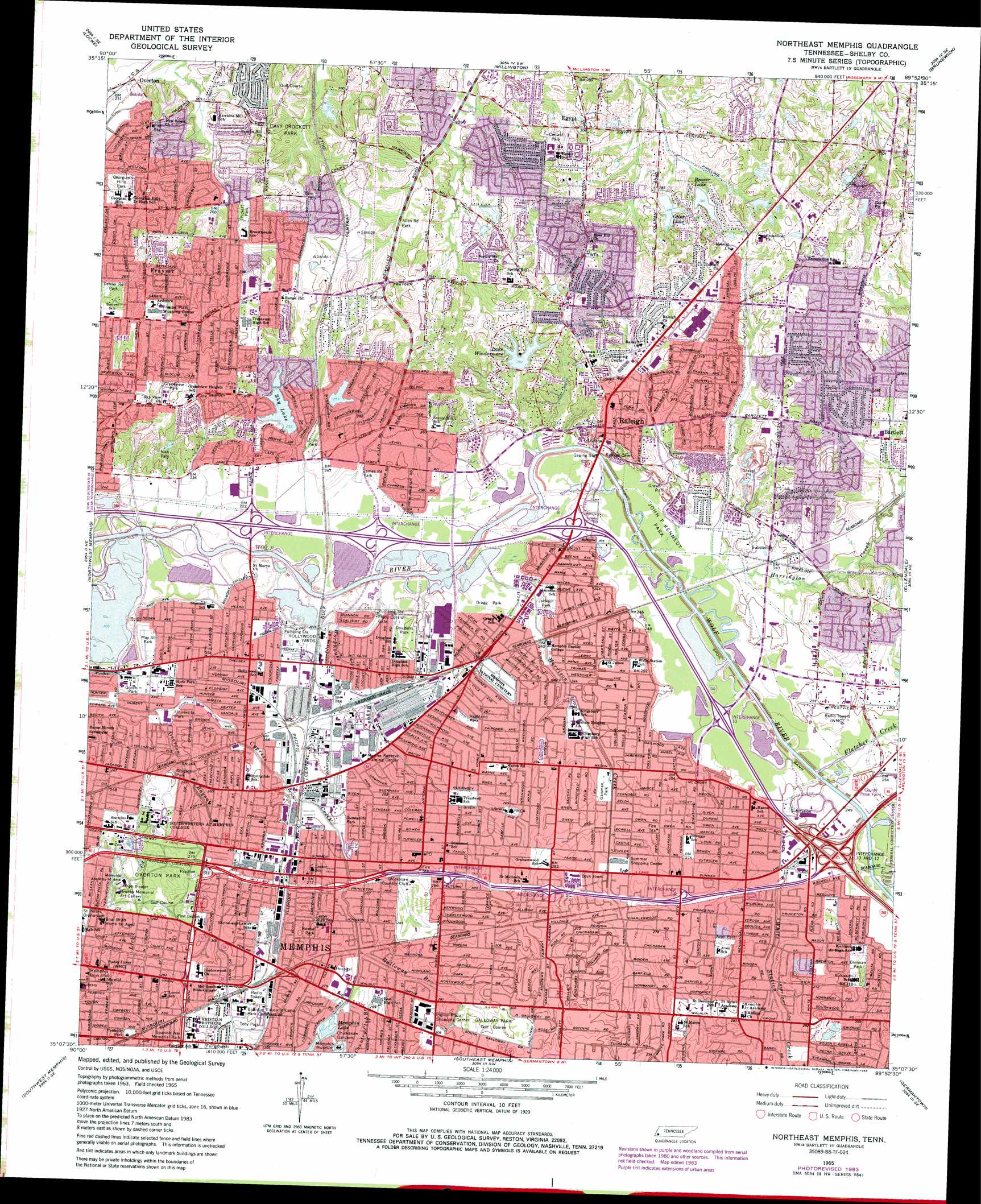
USGS Topo Quad 35089b8 - 1:24,000 scale
| Topo Map Name: | Northeast Memphis |
| USGS Topo Quad ID: | 35089b8 |
| Print Size: | ca. 21 1/4" wide x 27" high |
| Southeast Coordinates: | 35.125° N latitude / 89.875° W longitude |
| Map Center Coordinates: | 35.1875° N latitude / 89.9375° W longitude |
| U.S. State: | TN |
| Filename: | o35089b8.jpg |
| Download Map JPG Image: | Northeast Memphis topo map 1:24,000 scale |
| Map Type: | Topographic |
| Topo Series: | 7.5´ |
| Map Scale: | 1:24,000 |
| Source of Map Images: | United States Geological Survey (USGS) |
| Alternate Map Versions: |
Northeast Memphis TN 1965, updated 1967 Download PDF Buy paper map Northeast Memphis TN 1965, updated 1974 Download PDF Buy paper map Northeast Memphis TN 1965, updated 1983 Download PDF Buy paper map Northeast Memphis TN 1965, updated 1994 Download PDF Buy paper map Northeast Memphis TN 1997, updated 1999 Download PDF Buy paper map Northeast Memphis TN 2010 Download PDF Buy paper map Northeast Memphis TN 2013 Download PDF Buy paper map Northeast Memphis TN 2016 Download PDF Buy paper map |
1:24,000 Topo Quads surrounding Northeast Memphis
Frenchmans Bayou |
Pecan Point |
Drummonds |
Munford |
Brighton |
Jericho |
Locke |
Millington |
Brunswick |
Arlington |
West Memphis |
Northwest Memphis |
Northeast Memphis |
Ellendale |
Eads |
Fletcher Lake |
Southwest Memphis |
Southeast Memphis |
Germantown |
Collierville |
Lake Cormorant |
Horn Lake |
Pleasant Hill |
Olive Branch |
Byhalia Nw |
> Back to 35089a1 at 1:100,000 scale
> Back to 35088a1 at 1:250,000 scale
> Back to U.S. Topo Maps home
Northeast Memphis topo map: Gazetteer
Northeast Memphis: Airports
Shelby County Sheriffs Department Substation Airport elevation 72m 236′Northeast Memphis: Crossings
Interchange 10 elevation 73m 239′Interchange 12A elevation 82m 269′
Interchange 12B elevation 82m 269′
Interchange 12C elevation 81m 265′
Interchange 5 elevation 67m 219′
Interchange 6 elevation 68m 223′
Interchange 8 elevation 74m 242′
Northeast Memphis: Dams
Beaver Lake Dam elevation 89m 291′Gordon Gordons Lake Dam elevation 89m 291′
Lake Windermere Dam elevation 86m 282′
Lochnevin Dam elevation 80m 262′
Otter Lake Dam elevation 87m 285′
Sky Lake Dam elevation 74m 242′
Northeast Memphis: Lakes
Beaver Lake elevation 88m 288′Memphis Lake elevation 81m 265′
Northeast Memphis: Parks
Alburty Pool elevation 82m 269′Allen Road Park elevation 82m 269′
Avon Park elevation 85m 278′
Binghampton Park elevation 88m 288′
Bland Field elevation 89m 291′
Boshwit Courtyard elevation 92m 301′
Brennan Park elevation 91m 298′
Buc Baseball Field elevation 92m 301′
Buckman Quadrangle elevation 90m 295′
Canale Pool elevation 85m 278′
Central Park elevation 88m 288′
Chickasaw Gardens elevation 88m 288′
Davy Crockett Park elevation 87m 285′
Denver Road Park elevation 78m 255′
Dlugach Park elevation 76m 249′
Douglass Park elevation 74m 242′
East Park elevation 80m 262′
Ellis Park elevation 71m 232′
Fargason Field elevation 79m 259′
Fisher Memorial Garden elevation 82m 269′
Gaisman Park elevation 78m 255′
Galloway Park elevation 91m 298′
Georgian Hills Park elevation 81m 265′
Gooch Park elevation 73m 239′
Gragg Park elevation 73m 239′
Grandview Park elevation 92m 301′
Harry C Pierotti Park elevation 107m 351′
Highland Park elevation 79m 259′
Hollywood Park elevation 74m 242′
Howse Park elevation 86m 282′
Jackson Park elevation 75m 246′
James Road Park elevation 71m 232′
John F Kennedy Park elevation 69m 226′
May Street Park elevation 69m 226′
Memphis Zoological Garden elevation 78m 255′
Nolan Field elevation 89m 291′
Overton Park elevation 83m 272′
Peabody Park elevation 88m 288′
Pickett Park elevation 79m 259′
Raleigh-Bartlett Meadows Park elevation 89m 291′
Rodney Baber Park elevation 68m 223′
Signalgo Field elevation 88m 288′
Solomon Field elevation 78m 255′
Spanish War Memorial Park elevation 94m 308′
Sunnyside Park elevation 76m 249′
Toby Park elevation 93m 305′
Treadwell Park elevation 80m 262′
University Park elevation 71m 232′
Vieh Park elevation 86m 282′
Northeast Memphis: Populated Places
Aulon elevation 85m 278′Berclair elevation 83m 272′
Binghampton elevation 80m 262′
Cedar Grove (historical) elevation 78m 255′
Chickasaw Gardens elevation 82m 269′
Egypt elevation 92m 301′
Hedgemoor elevation 89m 291′
Hollywood elevation 74m 242′
Lenox elevation 91m 298′
Morningside Park elevation 92m 301′
Overton elevation 76m 249′
Raleigh elevation 80m 262′
Wells elevation 74m 242′
Northeast Memphis: Post Offices
Binghamton Post Office elevation 74m 242′East Memphis Post Office elevation 89m 291′
Highland Heights Post Office elevation 85m 278′
Hollywood Post Office elevation 74m 242′
Raleigh Post Office elevation 104m 341′
Northeast Memphis: Reservoirs
Gordon Gordons Lake elevation 89m 291′Lake Windermere elevation 86m 282′
Lochnevin Lake elevation 80m 262′
Otter Lake elevation 87m 285′
Sky Lake elevation 74m 242′
Northeast Memphis: Streams
Arlington Bayou elevation 84m 275′Belleair Branch elevation 80m 262′
Country Club Branch elevation 77m 252′
Cumberland Bayou elevation 76m 249′
Fletcher Creek elevation 69m 226′
Galloway Branch elevation 78m 255′
Harrington Creek elevation 67m 219′
Harrison Creek elevation 68m 223′
Lenox Bayou elevation 79m 259′
Overton Bayou elevation 68m 223′
White Station Creek elevation 72m 236′
Workhouse Bayou elevation 62m 203′
Northeast Memphis digital topo map on disk
Buy this Northeast Memphis topo map showing relief, roads, GPS coordinates and other geographical features, as a high-resolution digital map file on DVD: