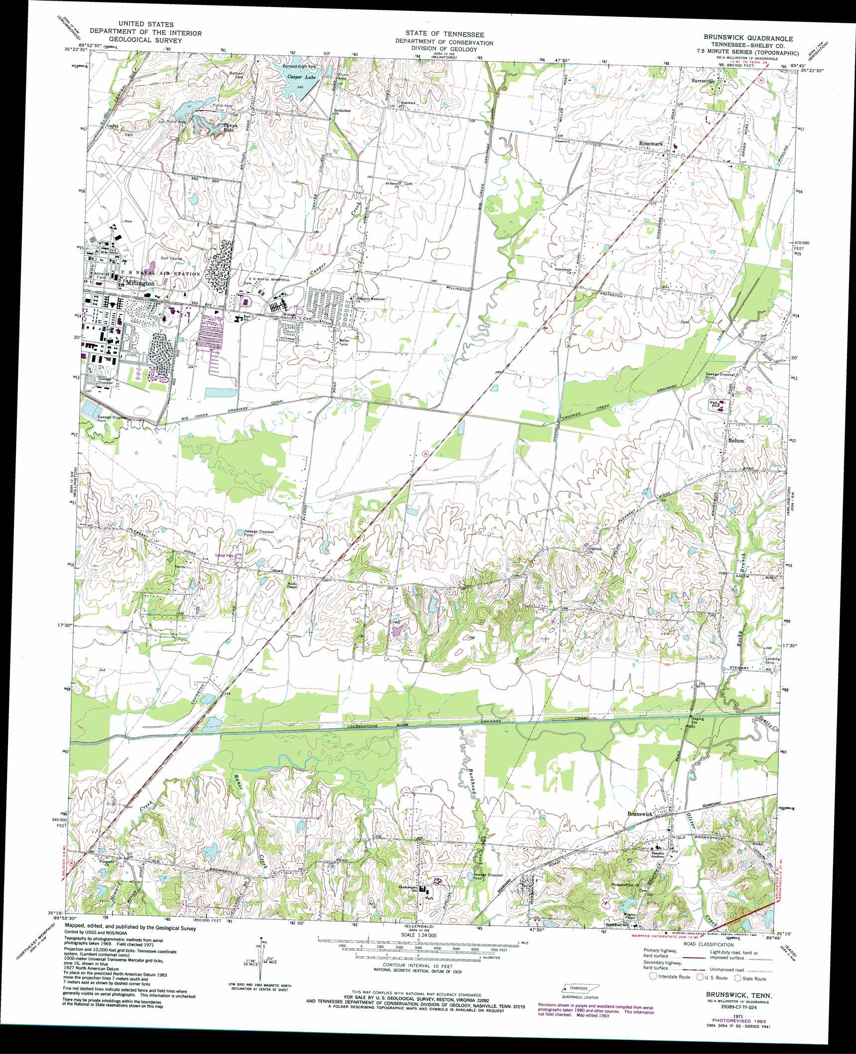
Brunswick Topo Map Tennessee
To zoom in, hover over the map of Brunswick
USGS Topo Quad 35089c7 - 1:24,000 scale
| Topo Map Name: | Brunswick |
| USGS Topo Quad ID: | 35089c7 |
| Print Size: | ca. 21 1/4" wide x 27" high |
| Southeast Coordinates: | 35.25° N latitude / 89.75° W longitude |
| Map Center Coordinates: | 35.3125° N latitude / 89.8125° W longitude |
| U.S. State: | TN |
| Filename: | o35089c7.jpg |
| Download Map JPG Image: | Brunswick topo map 1:24,000 scale |
| Map Type: | Topographic |
| Topo Series: | 7.5´ |
| Map Scale: | 1:24,000 |
| Source of Map Images: | United States Geological Survey (USGS) |
| Alternate Map Versions: |
Brunswick TN 1971, updated 1974 Download PDF Buy paper map Brunswick TN 1971, updated 1984 Download PDF Buy paper map Brunswick TN 1971, updated 1994 Download PDF Buy paper map Brunswick TN 2010 Download PDF Buy paper map Brunswick TN 2013 Download PDF Buy paper map Brunswick TN 2016 Download PDF Buy paper map |
1:24,000 Topo Quads surrounding Brunswick
Wilson |
Nodena |
Gilt Edge |
Covington |
Gift |
Pecan Point |
Drummonds |
Munford |
Brighton |
Mason |
Locke |
Millington |
Brunswick |
Arlington |
Gallaway |
Northwest Memphis |
Northeast Memphis |
Ellendale |
Eads |
Oakland |
Southwest Memphis |
Southeast Memphis |
Germantown |
Collierville |
Rossville |
> Back to 35089a1 at 1:100,000 scale
> Back to 35088a1 at 1:250,000 scale
> Back to U.S. Topo Maps home
Brunswick topo map: Gazetteer
Brunswick: Canals
Crooked Creek Drainage Canal elevation 89m 291′Loosahatchie River Drainage Canal elevation 70m 229′
Brunswick: Dams
Casper Lake Dam elevation 104m 341′Downing Dam elevation 104m 341′
J D Williams Lake Dam elevation 91m 298′
Brunswick: Lakes
Tanya Lake elevation 93m 305′Brunswick: Parks
Edmund Orgill Park elevation 106m 347′Brunswick: Populated Places
Barretville elevation 108m 354′Bolton elevation 97m 318′
Brunswick elevation 79m 259′
Bush Grove elevation 105m 344′
Gildfield elevation 97m 318′
Pearley (historical) elevation 78m 255′
Prosperity elevation 86m 282′
Rosemark elevation 101m 331′
Williams Chapel elevation 88m 288′
Brunswick: Reservoirs
Casper Lake elevation 104m 341′Downing Lake elevation 104m 341′
J D Williams Lake elevation 91m 298′
Brunswick: Streams
Buckhead Creek elevation 73m 239′Casper Creek elevation 78m 255′
Crooked Creek elevation 81m 265′
Howard Creek elevation 70m 229′
Oliver Creek elevation 75m 246′
Raner Creek elevation 70m 229′
Rocky Branch elevation 75m 246′
Scotts Creek elevation 75m 246′
Brunswick digital topo map on disk
Buy this Brunswick topo map showing relief, roads, GPS coordinates and other geographical features, as a high-resolution digital map file on DVD: