Nodena Topo Map Tennessee
To zoom in, hover over the map of Nodena
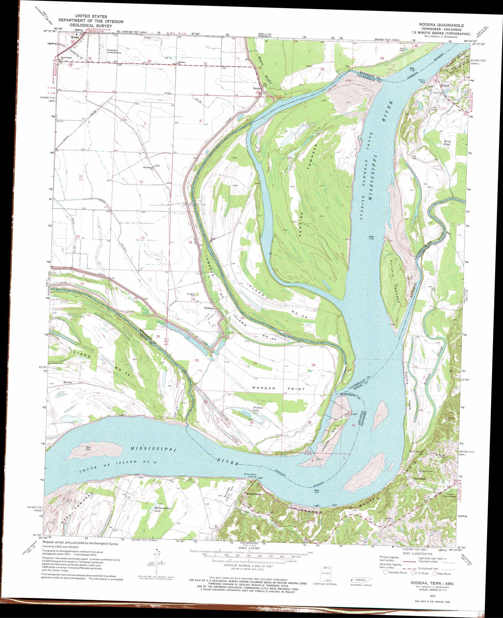
USGS Topo Quad 35089e8 - 1:24,000 scale
| Topo Map Name: | Nodena |
| USGS Topo Quad ID: | 35089e8 |
| Print Size: | ca. 21 1/4" wide x 27" high |
| Southeast Coordinates: | 35.5° N latitude / 89.875° W longitude |
| Map Center Coordinates: | 35.5625° N latitude / 89.9375° W longitude |
| U.S. States: | TN, AR |
| Filename: | o35089e8.jpg |
| Download Map JPG Image: | Nodena topo map 1:24,000 scale |
| Map Type: | Topographic |
| Topo Series: | 7.5´ |
| Map Scale: | 1:24,000 |
| Source of Map Images: | United States Geological Survey (USGS) |
| Alternate Map Versions: |
Nodena AR 1972, updated 1975 Download PDF Buy paper map Nodena AR 1972, updated 1984 Download PDF Buy paper map Nodena AR 2011 Download PDF Buy paper map Nodena AR 2014 Download PDF Buy paper map |
1:24,000 Topo Quads surrounding Nodena
Manila South |
Dell |
Luxora |
Rosa |
Open Lake |
Etowah |
Keiser |
Osceola |
Golddust |
Fort Pillow |
Joiner |
Wilson |
Nodena |
Gilt Edge |
Covington |
Frenchmans Bayou |
Pecan Point |
Drummonds |
Munford |
Brighton |
Jericho |
Locke |
Millington |
Brunswick |
Arlington |
> Back to 35089e1 at 1:100,000 scale
> Back to 35088a1 at 1:250,000 scale
> Back to U.S. Topo Maps home
Nodena topo map: Gazetteer
Nodena: Airports
Ohlendorf Airport elevation 72m 236′Nodena: Bars
Island Thirtyfour Bend Bar elevation 65m 213′Lookout Bar elevation 64m 209′
Morgan Point Bar elevation 65m 213′
Reverie Bar elevation 63m 206′
Nodena: Bends
Bend of Island Number Thirtyfive elevation 65m 213′Nodena Bend elevation 63m 206′
Nodena: Canals
Ditch Number 16 elevation 72m 236′Ditch Number 22 A elevation 68m 223′
Ditch Number 22 B elevation 70m 229′
Ditch Number 22 C elevation 69m 226′
Ditch Number 25 elevation 70m 229′
Nodena: Capes
Morgan Point elevation 73m 239′Nodena: Channels
Chute of Island Number 35 elevation 63m 206′Sunrise Towhead Chute elevation 64m 209′
Nodena: Cliffs
Chickasaw Bluff Number Two elevation 103m 337′Nodena: Flats
Hatchie Island elevation 73m 239′Neal Towhead elevation 69m 226′
Nodena: Guts
Ballard Slough elevation 71m 232′Nodena: Islands
Hatchie Towhead elevation 72m 236′Island Number Thirty-four elevation 73m 239′
Randolph Towhead elevation 66m 216′
Sunrise Towhead elevation 70m 229′
Towhead of Island Number 34 elevation 70m 229′
Nodena: Lakes
McLaughlin Lake elevation 72m 236′Payne Lake (historical) elevation 72m 236′
Preston Lake elevation 68m 223′
Nodena: Levees
Below Richardsons Landing Dikes elevation 65m 213′Chute of Island Number Thirtyfive Revetment elevation 63m 206′
Lookout Bar Revetment elevation 73m 239′
Lookout Dikes elevation 72m 236′
Lookout Revetment elevation 64m 209′
Morgan Point Dikes elevation 70m 229′
Morgan Point Dikes elevation 64m 209′
Sunrise Island Revetment elevation 64m 209′
Nodena: Parks
Nodena Site elevation 73m 239′Nodena: Populated Places
Butler elevation 73m 239′Fulton elevation 85m 278′
Nodena elevation 72m 236′
Randolph elevation 96m 314′
Richardsons elevation 77m 252′
Upper Nodena (historical) elevation 72m 236′
Nodena: Post Offices
Fulton Post Office (historical) elevation 87m 285′Reverie Post Office (historical) elevation 73m 239′
Nodena: Streams
Hatchie River elevation 64m 209′Rapee Bayou elevation 68m 223′
Sugar Creek elevation 64m 209′
Nodena: Swamps
King Pond elevation 70m 229′Nodena digital topo map on disk
Buy this Nodena topo map showing relief, roads, GPS coordinates and other geographical features, as a high-resolution digital map file on DVD: