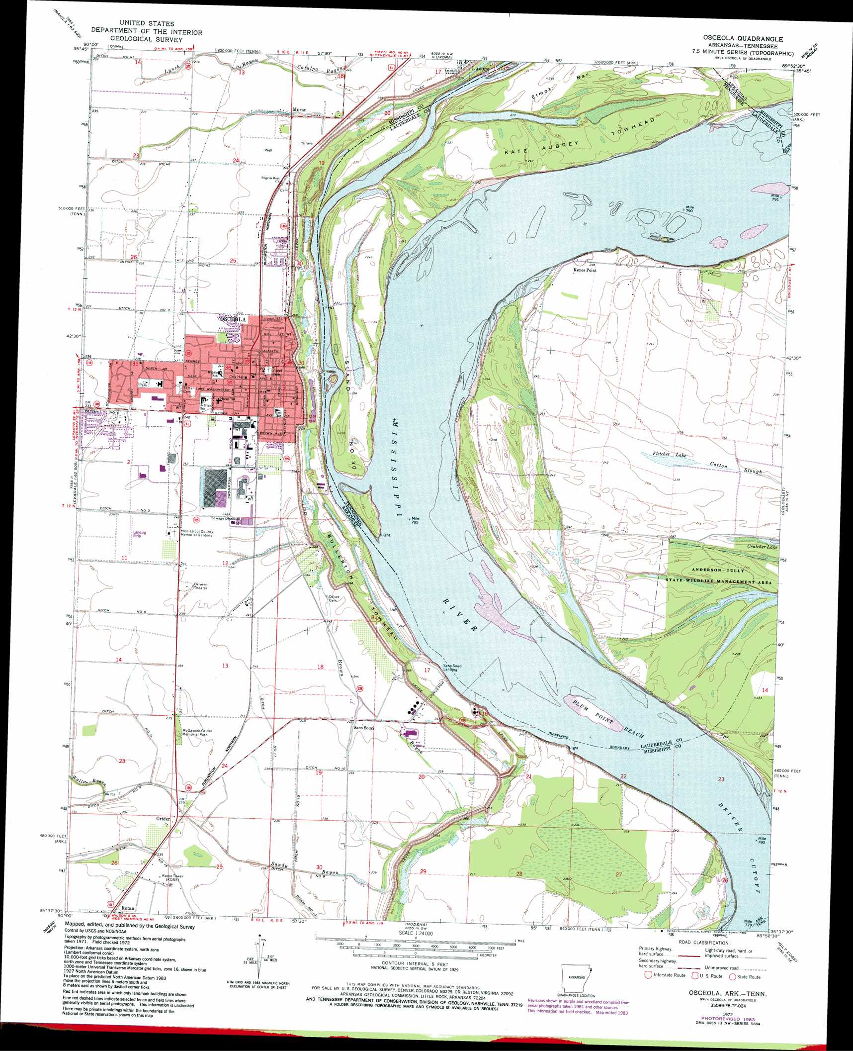
Osceola Topo Map Arkansas
To zoom in, hover over the map of Osceola
USGS Topo Quad 35089f8 - 1:24,000 scale
| Topo Map Name: | Osceola |
| USGS Topo Quad ID: | 35089f8 |
| Print Size: | ca. 21 1/4" wide x 27" high |
| Southeast Coordinates: | 35.625° N latitude / 89.875° W longitude |
| Map Center Coordinates: | 35.6875° N latitude / 89.9375° W longitude |
| U.S. States: | AR, TN |
| Filename: | o35089f8.jpg |
| Download Map JPG Image: | Osceola topo map 1:24,000 scale |
| Map Type: | Topographic |
| Topo Series: | 7.5´ |
| Map Scale: | 1:24,000 |
| Source of Map Images: | United States Geological Survey (USGS) |
| Alternate Map Versions: |
Osceola AR 1972, updated 1975 Download PDF Buy paper map Osceola AR 1972, updated 1984 Download PDF Buy paper map Osceola AR 2011 Download PDF Buy paper map Osceola AR 2014 Download PDF Buy paper map |
1:24,000 Topo Quads surrounding Osceola
Manila North |
Half Moon |
Blytheville |
Armorel |
Chic |
Manila South |
Dell |
Luxora |
Rosa |
Open Lake |
Etowah |
Keiser |
Osceola |
Golddust |
Fort Pillow |
Joiner |
Wilson |
Nodena |
Gilt Edge |
Covington |
Frenchmans Bayou |
Pecan Point |
Drummonds |
Munford |
Brighton |
> Back to 35089e1 at 1:100,000 scale
> Back to 35088a1 at 1:250,000 scale
> Back to U.S. Topo Maps home
Osceola topo map: Gazetteer
Osceola: Airports
Grandview Street Heliport elevation 72m 236′Harwell Airport elevation 72m 236′
Osceola: Bars
Elmot Bar elevation 75m 246′Plum Point Bar elevation 70m 229′
Osceola: Bends
Driver Cutoff elevation 66m 216′Plum Point Bend elevation 66m 216′
Osceola: Canals
Ditch Number 10 elevation 73m 239′Ditch Number 11 elevation 72m 236′
Ditch Number 12 elevation 72m 236′
Ditch Number 14 elevation 72m 236′
Ditch Number 2 elevation 69m 226′
Ditch Number 2-A elevation 69m 226′
Ditch Number 3 elevation 72m 236′
Ditch Number 3-A elevation 71m 232′
Ditch Number 5 elevation 71m 232′
Ditch Number 9 elevation 72m 236′
Osceola: Capes
Craighead Point elevation 66m 216′Keyes Point elevation 66m 216′
Plum Point elevation 72m 236′
Osceola: Channels
Plum Point Reach elevation 65m 213′Osceola: Dams
Fort Pillow Street Park Lake Dam elevation 72m 236′Osceola: Flats
Kate Aubrey Towhead elevation 72m 236′Osceola: Islands
Bullerton Towhead elevation 74m 242′Island Number Thirty elevation 70m 229′
Osceola: Lakes
Fletcher Lake elevation 73m 239′Osceola: Levees
Elmont Bar Revetment elevation 66m 216′Island Number Thirty Revetment elevation 72m 236′
Kate Aubrey Dikes elevation 66m 216′
Keyes Point Dikes elevation 66m 216′
Lower Bullerton Revetment elevation 70m 229′
Osceola Revetment elevation 67m 219′
Plum Point Dikes elevation 67m 219′
Upper Bullerton Revetment elevation 67m 219′
Osceola: Parks
Florida Park elevation 71m 232′Hale Avenue Historic District elevation 73m 239′
McGavock-Grider Memorial Park elevation 72m 236′
Osceola: Populated Places
Grider elevation 74m 242′Keyes Point elevation 76m 249′
Moran elevation 71m 232′
Osceola elevation 73m 239′
Rotan elevation 73m 239′
Sans Souci elevation 74m 242′
Osceola: Post Offices
Osceola Post Office elevation 73m 239′Osceola: Reservoirs
Fort Pillow Street Park Lake elevation 72m 236′Osceola: Streams
Brown Bayou elevation 72m 236′Catalpa Bayou elevation 74m 242′
Lynch Bayou elevation 72m 236′
Waller Bayou elevation 72m 236′
Osceola digital topo map on disk
Buy this Osceola topo map showing relief, roads, GPS coordinates and other geographical features, as a high-resolution digital map file on DVD: