Ripley North Topo Map Tennessee
To zoom in, hover over the map of Ripley North
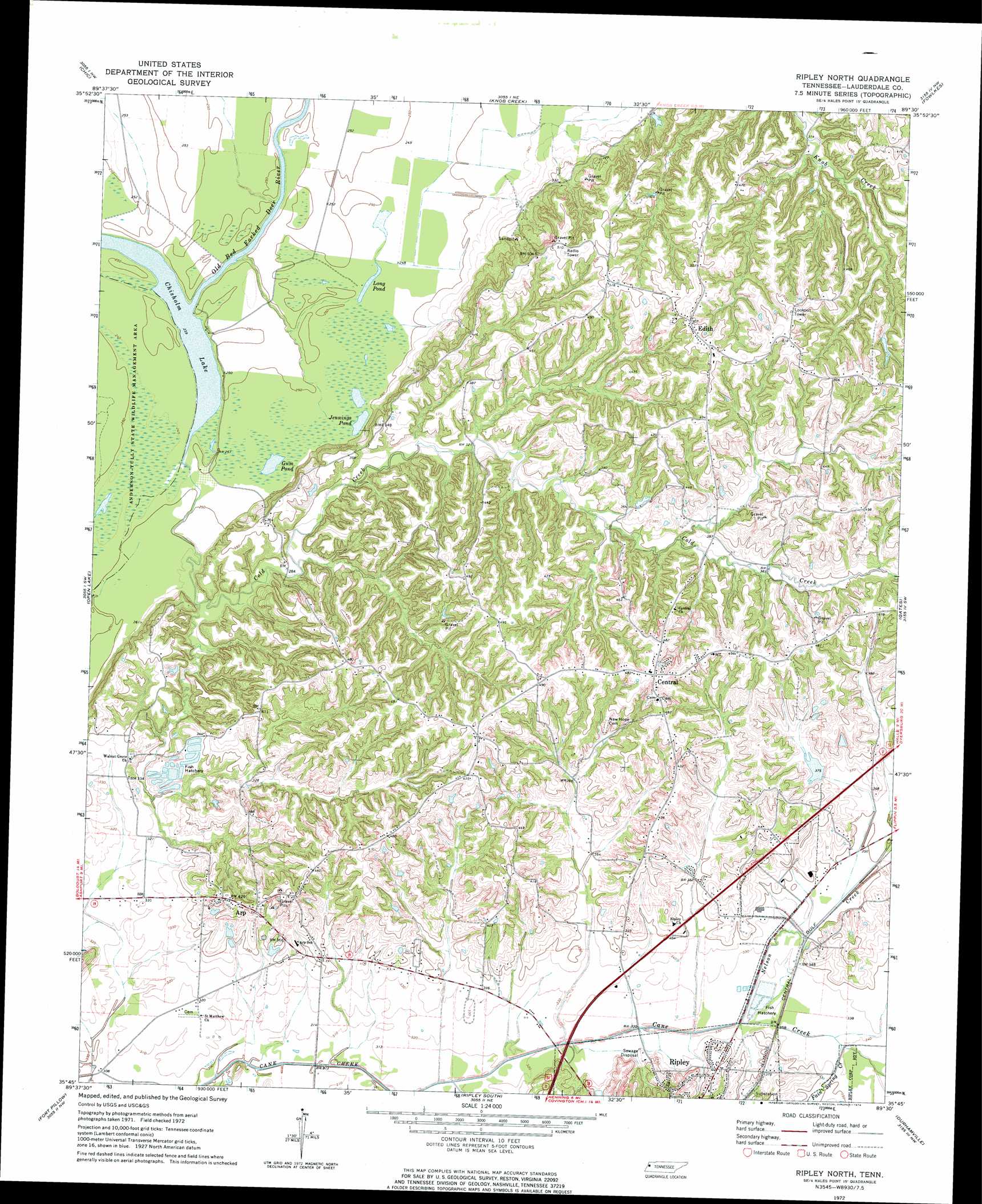
USGS Topo Quad 35089g5 - 1:24,000 scale
| Topo Map Name: | Ripley North |
| USGS Topo Quad ID: | 35089g5 |
| Print Size: | ca. 21 1/4" wide x 27" high |
| Southeast Coordinates: | 35.75° N latitude / 89.5° W longitude |
| Map Center Coordinates: | 35.8125° N latitude / 89.5625° W longitude |
| U.S. State: | TN |
| Filename: | o35089g5.jpg |
| Download Map JPG Image: | Ripley North topo map 1:24,000 scale |
| Map Type: | Topographic |
| Topo Series: | 7.5´ |
| Map Scale: | 1:24,000 |
| Source of Map Images: | United States Geological Survey (USGS) |
| Alternate Map Versions: |
Ripley North TN 1972, updated 1974 Download PDF Buy paper map Ripley North TN 1972, updated 1974 Download PDF Buy paper map Ripley North TN 2010 Download PDF Buy paper map Ripley North TN 2013 Download PDF Buy paper map Ripley North TN 2016 Download PDF Buy paper map |
1:24,000 Topo Quads surrounding Ripley North
Steele |
Cottonwood Point |
Caruthersville Se |
Dyersburg |
Newbern |
Armorel |
Chic |
Knob Creek |
Fowlkes |
Bonicord |
Rosa |
Open Lake |
Ripley North |
Gates |
Chestnut Bluff |
Golddust |
Fort Pillow |
Ripley South |
Durhamville |
Tibbs |
Gilt Edge |
Covington |
Gift |
Turnpike |
Brownsville |
> Back to 35089e1 at 1:100,000 scale
> Back to 35088a1 at 1:250,000 scale
> Back to U.S. Topo Maps home
Ripley North topo map: Gazetteer
Ripley North: Airports
Flying I Ranch Airport elevation 101m 331′Ripley North: Dams
Bill Smith Lake Dam elevation 126m 413′Cane Creek Dam Number Nine elevation 114m 374′
Cane Creek Number Five Dam elevation 92m 301′
Ripley North: Lakes
Chisholm Lake elevation 73m 239′Gum Pond elevation 75m 246′
Jennings Pond elevation 75m 246′
Long Pond elevation 76m 249′
Separate Pond (historical) elevation 77m 252′
Ripley North: Populated Places
Arp elevation 130m 426′Central elevation 150m 492′
Edith elevation 153m 501′
Ripley North: Reservoirs
Bill Smith Lake elevation 126m 413′Cane Creek Lake Number Nine elevation 114m 374′
Cane Creek Number Five Lake elevation 92m 301′
Ripley North: Streams
Cold Creek elevation 73m 239′Fain Spring Creek elevation 103m 337′
Hyde Creek elevation 94m 308′
King Creek elevation 106m 347′
Nelson Creek elevation 98m 321′
Old Bed Forked Deer River elevation 73m 239′
Ripley North digital topo map on disk
Buy this Ripley North topo map showing relief, roads, GPS coordinates and other geographical features, as a high-resolution digital map file on DVD: