Open Lake Topo Map Tennessee
To zoom in, hover over the map of Open Lake
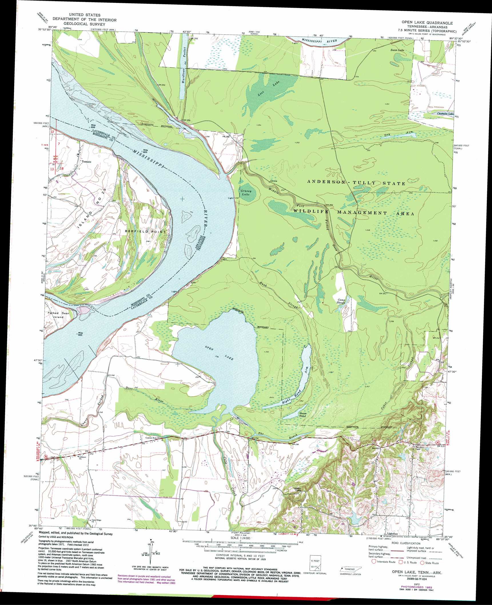
USGS Topo Quad 35089g6 - 1:24,000 scale
| Topo Map Name: | Open Lake |
| USGS Topo Quad ID: | 35089g6 |
| Print Size: | ca. 21 1/4" wide x 27" high |
| Southeast Coordinates: | 35.75° N latitude / 89.625° W longitude |
| Map Center Coordinates: | 35.8125° N latitude / 89.6875° W longitude |
| U.S. States: | TN, AR |
| Filename: | o35089g6.jpg |
| Download Map JPG Image: | Open Lake topo map 1:24,000 scale |
| Map Type: | Topographic |
| Topo Series: | 7.5´ |
| Map Scale: | 1:24,000 |
| Source of Map Images: | United States Geological Survey (USGS) |
| Alternate Map Versions: |
Open Lake TN 1972, updated 1975 Download PDF Buy paper map Open Lake TN 1972, updated 1983 Download PDF Buy paper map Open Lake TN 1972, updated 1983 Download PDF Buy paper map Open Lake TN 2011 Download PDF Buy paper map Open Lake TN 2013 Download PDF Buy paper map Open Lake TN 2016 Download PDF Buy paper map |
1:24,000 Topo Quads surrounding Open Lake
Denton |
Steele |
Cottonwood Point |
Caruthersville Se |
Dyersburg |
Blytheville |
Armorel |
Chic |
Knob Creek |
Fowlkes |
Luxora |
Rosa |
Open Lake |
Ripley North |
Gates |
Osceola |
Golddust |
Fort Pillow |
Ripley South |
Durhamville |
Nodena |
Gilt Edge |
Covington |
Gift |
Turnpike |
> Back to 35089e1 at 1:100,000 scale
> Back to 35088a1 at 1:250,000 scale
> Back to U.S. Topo Maps home
Open Lake topo map: Gazetteer
Open Lake: Bars
Island Number Twentysix Bar elevation 68m 223′Lassiter Bar elevation 70m 229′
Open Lake: Bends
Bend of Island Number Twentyfive elevation 69m 226′Open Lake: Capes
Barfield Point elevation 74m 242′Open Lake: Channels
The Reach elevation 73m 239′Open Lake: Dams
Cane Creek Number Three Dam elevation 96m 314′Open Lake: Islands
Island Number 25 elevation 77m 252′Open Lake: Lakes
Camp Slough elevation 76m 249′Dry Arm elevation 74m 242′
Goose Pond elevation 72m 236′
Grassy Lake elevation 76m 249′
Lost Lake elevation 77m 252′
Open Lake elevation 73m 239′
Right Hand Arm elevation 72m 236′
Swan Lake elevation 76m 249′
Wardlows Pocket elevation 74m 242′
Open Lake: Levees
Bend of Island Number Twentyfive Revetment elevation 77m 252′Forked Deer Dikes elevation 68m 223′
Island 25 Dikes elevation 69m 226′
Obion-Tamm Revetment elevation 70m 229′
Open Lake: Parks
Anderson-Tully State Wildlife Management Area elevation 76m 249′Chickasaw National Wildlife Refuge elevation 76m 249′
Open Lake: Populated Places
Tomato elevation 75m 246′Open Lake: Reservoirs
Cane Creek Number Three Lake elevation 96m 314′Open Lake: Streams
Coker Slough elevation 73m 239′Middle Fork Forked Deer River elevation 69m 226′
Rush Slough elevation 73m 239′
Open Lake digital topo map on disk
Buy this Open Lake topo map showing relief, roads, GPS coordinates and other geographical features, as a high-resolution digital map file on DVD: