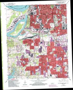
Southwest Memphis Topo Map Tennessee
To zoom in, hover over the map of Southwest Memphis
USGS Topo Quad 35090a1 - 1:24,000 scale
| Topo Map Name: | Southwest Memphis |
| USGS Topo Quad ID: | 35090a1 |
| Print Size: | ca. 21 1/4" wide x 27" high |
| Southeast Coordinates: | 35° N latitude / 90° W longitude |
| Map Center Coordinates: | 35.0625° N latitude / 90.0625° W longitude |
| U.S. States: | TN, AR |
| Filename: | o35090a1.jpg |
| Download Map JPG Image: | Southwest Memphis topo map 1:24,000 scale |
| Map Type: | Topographic |
| Topo Series: | 7.5´ |
| Map Scale: | 1:24,000 |
| Source of Map Images: | United States Geological Survey (USGS) |
| Alternate Map Versions: |
Southwest Memphis TN 1965, updated 1967 Download PDF Buy paper map Southwest Memphis TN 1965, updated 1974 Download PDF Buy paper map Southwest Memphis TN 1965, updated 1988 Download PDF Buy paper map Southwest Memphis TN 1965, updated 1993 Download PDF Buy paper map Southwest Memphis TN 1965, updated 1993 Download PDF Buy paper map Southwest Memphis TN 2011 Download PDF Buy paper map Southwest Memphis TN 2013 Download PDF Buy paper map Southwest Memphis TN 2016 Download PDF Buy paper map |
1:24,000 Topo Quads surrounding Southwest Memphis
> Back to 35090a1 at 1:100,000 scale
> Back to 35090a1 at 1:250,000 scale
> Back to U.S. Topo Maps home
Southwest Memphis topo map: Gazetteer
Southwest Memphis: Airports
Isle-A-Port Airport elevation 66m 216′Southwest Memphis: Canals
Horn Lake Cutoff elevation 67m 219′Southwest Memphis: Channels
Harbor Channel elevation 56m 183′Southwest Memphis: Crossings
Interchange 10 elevation 85m 278′Interchange 11 elevation 80m 262′
Interchange 12 elevation 82m 269′
Interchange 2 elevation 88m 288′
Interchange 24 elevation 73m 239′
Interchange 26 elevation 81m 265′
Interchange 28 elevation 91m 298′
Interchange 5 elevation 76m 249′
Interchange 6 and 25 elevation 72m 236′
Interchange 8 elevation 66m 216′
Interchange 9 elevation 76m 249′
Southwest Memphis: Dams
Coro Lake Dam elevation 71m 232′J C May Lake Dam elevation 79m 259′
Southwest Memphis: Islands
Treasure Island elevation 64m 209′Southwest Memphis: Lakes
Lake McKellar elevation 56m 183′Robco Lake elevation 68m 223′
Southwest Memphis: Levees
Presidents Island Dikes and Retards elevation 68m 223′Presidents Island Revetment elevation 62m 203′
Tennessee Chute Revetment elevation 57m 187′
Southwest Memphis: Parks
Alonzo Weaver Park elevation 70m 229′Bellevue Park elevation 91m 298′
Belz Park elevation 87m 285′
Bison Park elevation 71m 232′
Booth Park elevation 87m 285′
Chandler Park elevation 92m 301′
Chickasaw Park elevation 73m 239′
Crump Park elevation 77m 252′
Dalstrom Park elevation 86m 282′
De Soto Park elevation 87m 285′
Falcon Park elevation 76m 249′
Ford Park elevation 79m 259′
Fuller State Park elevation 87m 285′
Gaston Park elevation 92m 301′
Geeter Park elevation 90m 295′
Glenview Park elevation 85m 278′
Lanier Park elevation 82m 269′
Lincoln Park elevation 74m 242′
Lincoln Park elevation 85m 278′
Mississippi Park elevation 74m 242′
O L Cash Park elevation 77m 252′
Otis Redding Park elevation 91m 298′
Patton Park elevation 85m 278′
Pine Hills Park elevation 76m 249′
Raines-Finley Park elevation 90m 295′
Riverside Park elevation 75m 246′
Riverview Park elevation 77m 252′
Roosevelt Park elevation 76m 249′
South Side Park elevation 94m 308′
Western Park elevation 85m 278′
Westwood Park elevation 78m 255′
Whitehaven Lane Park elevation 94m 308′
Williams Park elevation 86m 282′
Southwest Memphis: Populated Places
Acklena elevation 81m 265′Bunker Hill elevation 88m 288′
Darwin elevation 87m 285′
East Junction elevation 71m 232′
Goodman elevation 89m 291′
Mallory elevation 77m 252′
New South Memphis elevation 79m 259′
Nonconnah elevation 73m 239′
Persey elevation 83m 272′
Pisgah Heights elevation 74m 242′
Raines elevation 91m 298′
Shadowlawn elevation 95m 311′
West Junction elevation 66m 216′
White Chapel elevation 95m 311′
Whitehaven elevation 92m 301′
Southwest Memphis: Post Offices
George W Lee Post Office elevation 92m 301′Mallory Post Office elevation 87m 285′
Whitehaven Post Office elevation 76m 249′
Southwest Memphis: Reservoirs
Coro Lake elevation 71m 232′J C May Lake elevation 79m 259′
Southwest Memphis: Streams
Arcadia Mills Bayou elevation 75m 246′Cane Creek elevation 62m 203′
Cemetery Bayou elevation 74m 242′
Cypress Creek elevation 57m 187′
Frisco Branch elevation 78m 255′
Hampson Bayou elevation 65m 213′
Incline Bayou elevation 59m 193′
Latham Branch elevation 70m 229′
Magnolia Branch elevation 76m 249′
Mallory Bayou elevation 65m 213′
Marjorie Bayou elevation 69m 226′
Mill Branch elevation 80m 262′
Mound Bayou elevation 79m 259′
Nonconnah Creek elevation 57m 187′
Orgill Bayou elevation 76m 249′
Riverside Bayou elevation 56m 183′
Slaughter House Bayou elevation 70m 229′
Tarent Branch elevation 62m 203′
Zion Branch elevation 82m 269′
Southwest Memphis digital topo map on disk
Buy this Southwest Memphis topo map showing relief, roads, GPS coordinates and other geographical features, as a high-resolution digital map file on DVD:


