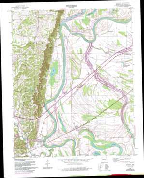
Madison Topo Map Arkansas
To zoom in, hover over the map of Madison
USGS Topo Quad 35090a6 - 1:24,000 scale
| Topo Map Name: | Madison |
| USGS Topo Quad ID: | 35090a6 |
| Print Size: | ca. 21 1/4" wide x 27" high |
| Southeast Coordinates: | 35° N latitude / 90.625° W longitude |
| Map Center Coordinates: | 35.0625° N latitude / 90.6875° W longitude |
| U.S. State: | AR |
| Filename: | o35090a6.jpg |
| Download Map JPG Image: | Madison topo map 1:24,000 scale |
| Map Type: | Topographic |
| Topo Series: | 7.5´ |
| Map Scale: | 1:24,000 |
| Source of Map Images: | United States Geological Survey (USGS) |
| Alternate Map Versions: |
Madison AR 1960, updated 1960 Download PDF Buy paper map Madison AR 1960, updated 1977 Download PDF Buy paper map Madison AR 1960, updated 1993 Download PDF Buy paper map Madison AR 2011 Download PDF Buy paper map Madison AR 2014 Download PDF Buy paper map |
1:24,000 Topo Quads surrounding Madison
> Back to 35090a1 at 1:100,000 scale
> Back to 35090a1 at 1:250,000 scale
> Back to U.S. Topo Maps home
Madison topo map: Gazetteer
Madison: Bars
Big Eddy Shoal elevation 55m 180′Bowman Bar elevation 57m 187′
Gibson Shoal elevation 54m 177′
Lower Shoal elevation 54m 177′
Madison: Bends
Bluff Bend elevation 53m 173′Booker Bend elevation 53m 173′
Bowman Bend elevation 54m 177′
Collins Bend elevation 54m 177′
Corw Bend elevation 56m 183′
Houston Bend elevation 58m 190′
Hunter Bend elevation 55m 180′
Merriman Bend elevation 55m 180′
Round Pond Cutoff elevation 53m 173′
Madison: Capes
Pickens Point elevation 72m 236′Madison: Cliffs
Burnt Mill Bluff elevation 74m 242′Doublehead Bluff elevation 66m 216′
Madison: Crossings
Barn Crossing elevation 54m 177′Crow Creek Crossing elevation 56m 183′
Interchange 247 elevation 69m 226′
McFall Crossing elevation 52m 170′
Madison: Dams
Forest Lake Number 4 Dam elevation 83m 272′Scenic Hills Lake Dam elevation 104m 341′
Madison: Lakes
Beaty Lake elevation 56m 183′Brushy Lake elevation 56m 183′
Burnt Cane Lake elevation 51m 167′
Fishers Lake (historical) elevation 57m 187′
Fishing Lake elevation 60m 196′
Horseshoe Lake elevation 56m 183′
Horseshoe Lake elevation 57m 187′
Hunter Lake (historical) elevation 56m 183′
Island Lake elevation 55m 180′
Kiethley Lake elevation 59m 193′
Round Pond Lake elevation 59m 193′
Madison: Populated Places
Burnt Cane elevation 63m 206′Cottonwood Corner elevation 63m 206′
Crow Creek elevation 73m 239′
Madison elevation 65m 213′
Newcastle elevation 126m 413′
Widener elevation 62m 203′
Madison: Rapids
Big Eddy elevation 55m 180′Gibson Eddy elevation 53m 173′
Madison: Reservoirs
Forest Lake Number 4 elevation 83m 272′Scenic Hills Lake elevation 104m 341′
Madison: Streams
Crow Creek elevation 58m 190′Little Crow Creek elevation 60m 196′
Madison digital topo map on disk
Buy this Madison topo map showing relief, roads, GPS coordinates and other geographical features, as a high-resolution digital map file on DVD:


