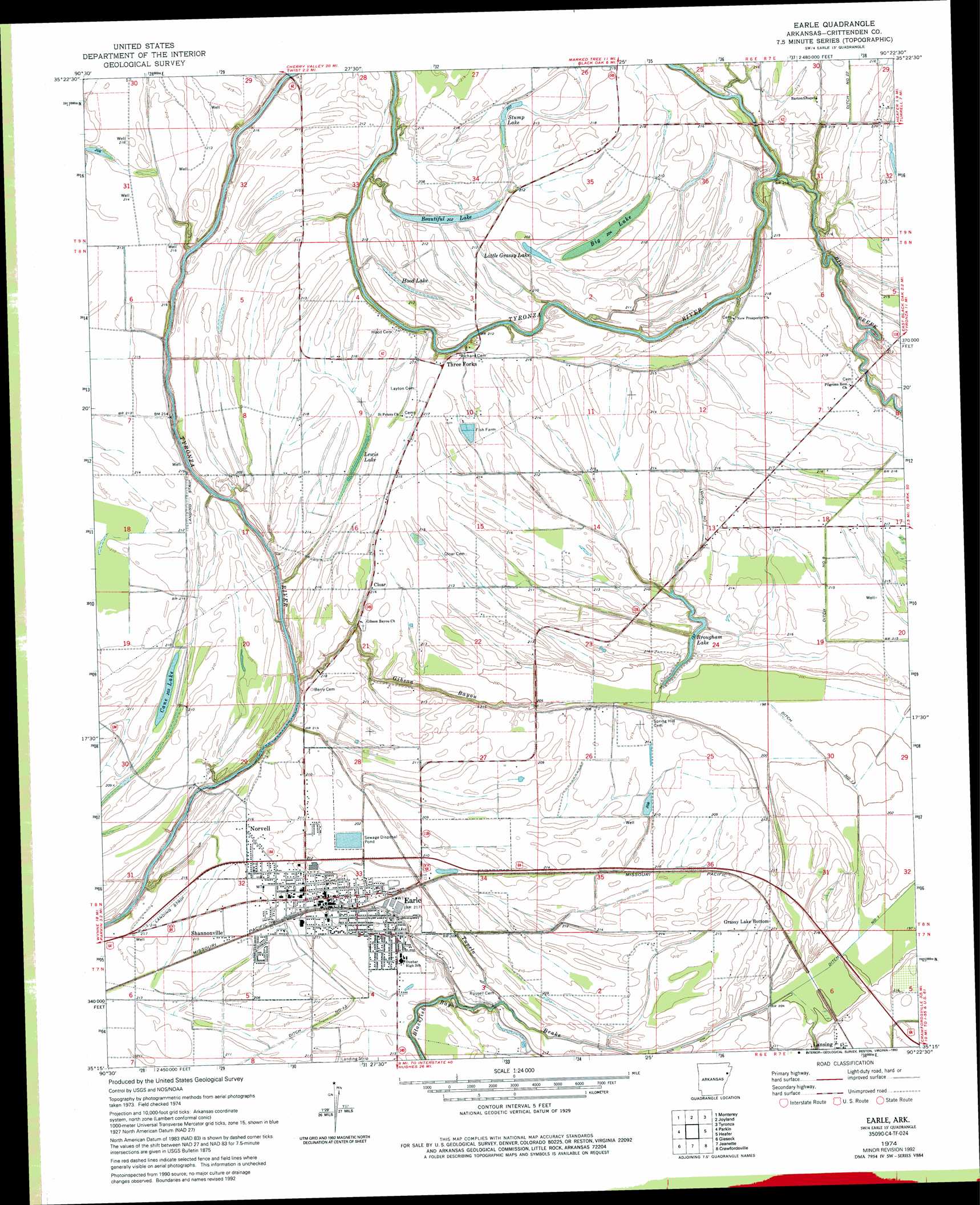
Earle Topo Map Arkansas
To zoom in, hover over the map of Earle
USGS Topo Quad 35090c4 - 1:24,000 scale
| Topo Map Name: | Earle |
| USGS Topo Quad ID: | 35090c4 |
| Print Size: | ca. 21 1/4" wide x 27" high |
| Southeast Coordinates: | 35.25° N latitude / 90.375° W longitude |
| Map Center Coordinates: | 35.3125° N latitude / 90.4375° W longitude |
| U.S. State: | AR |
| Filename: | o35090c4.jpg |
| Download Map JPG Image: | Earle topo map 1:24,000 scale |
| Map Type: | Topographic |
| Topo Series: | 7.5´ |
| Map Scale: | 1:24,000 |
| Source of Map Images: | United States Geological Survey (USGS) |
| Alternate Map Versions: |
Earle AR 1974 Download PDF Buy paper map Earle AR 1974, updated 1976 Download PDF Buy paper map Earle AR 2011 Download PDF Buy paper map Earle AR 2014 Download PDF Buy paper map |
1:24,000 Topo Quads surrounding Earle
Harrisburg |
Mccormick |
Marked Tree |
Lepanto |
Joiner |
Cherry Valley East |
Monterey |
Joyland |
Tyronza |
Frenchmans Bayou |
Princedale |
Parkin |
Earle |
Heafer |
Jericho |
Wittsburg |
Gieseck |
Jeanette |
Crawfordsville |
West Memphis |
Madison |
Round Pond |
Chatfield |
Edmondson |
Fletcher Lake |
> Back to 35090a1 at 1:100,000 scale
> Back to 35090a1 at 1:250,000 scale
> Back to U.S. Topo Maps home
Earle topo map: Gazetteer
Earle: Airports
McNeely Airport elevation 63m 206′Earle: Canals
Ditch Number 1 elevation 61m 200′Ditch Number 1 elevation 63m 206′
Ditch Number 13 elevation 61m 200′
Ditch Number 22 elevation 65m 213′
Ditch Number 9 elevation 63m 206′
Tupelo Brake elevation 62m 203′
Earle: Lakes
Beautiful Lake elevation 61m 200′Big Lake elevation 62m 203′
Brougham Lake elevation 59m 193′
Cane Lake elevation 61m 200′
Hood Lake elevation 61m 200′
Lewis Lake elevation 62m 203′
Little Grassy Lake elevation 62m 203′
Stump Lake elevation 62m 203′
Earle: Populated Places
Cloar elevation 64m 209′Earle elevation 63m 206′
Grassy Lake Bottom elevation 64m 209′
Lansing elevation 67m 219′
Norvell elevation 66m 216′
Poindexter elevation 66m 216′
Shannonville elevation 64m 209′
Three Forks elevation 65m 213′
Earle: Streams
Big Creek elevation 59m 193′Gibson Bayou elevation 59m 193′
Earle digital topo map on disk
Buy this Earle topo map showing relief, roads, GPS coordinates and other geographical features, as a high-resolution digital map file on DVD: