Frenchmans Bayou Topo Map Arkansas
To zoom in, hover over the map of Frenchmans Bayou
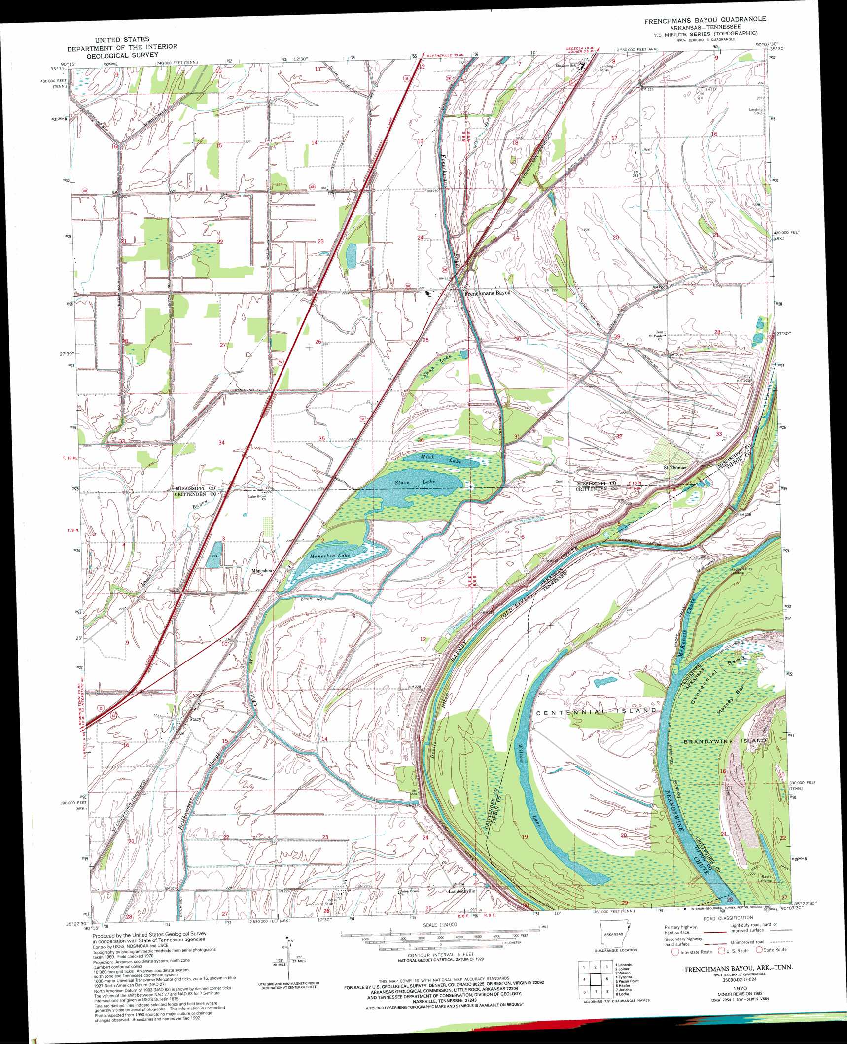
USGS Topo Quad 35090d2 - 1:24,000 scale
| Topo Map Name: | Frenchmans Bayou |
| USGS Topo Quad ID: | 35090d2 |
| Print Size: | ca. 21 1/4" wide x 27" high |
| Southeast Coordinates: | 35.375° N latitude / 90.125° W longitude |
| Map Center Coordinates: | 35.4375° N latitude / 90.1875° W longitude |
| U.S. States: | AR, TN |
| Filename: | o35090d2.jpg |
| Download Map JPG Image: | Frenchmans Bayou topo map 1:24,000 scale |
| Map Type: | Topographic |
| Topo Series: | 7.5´ |
| Map Scale: | 1:24,000 |
| Source of Map Images: | United States Geological Survey (USGS) |
| Alternate Map Versions: |
Frenchmans Bayou AR 1970, updated 1974 Download PDF Buy paper map Frenchmans Bayou AR 1970, updated 1993 Download PDF Buy paper map Frenchmans Bayou AR 2011 Download PDF Buy paper map Frenchmans Bayou AR 2014 Download PDF Buy paper map |
1:24,000 Topo Quads surrounding Frenchmans Bayou
Hatchie Coon |
Riverdale |
Etowah |
Keiser |
Osceola |
Marked Tree |
Lepanto |
Joiner |
Wilson |
Nodena |
Joyland |
Tyronza |
Frenchmans Bayou |
Pecan Point |
Drummonds |
Earle |
Heafer |
Jericho |
Locke |
Millington |
Jeanette |
Crawfordsville |
West Memphis |
Northwest Memphis |
Northeast Memphis |
> Back to 35090a1 at 1:100,000 scale
> Back to 35090a1 at 1:250,000 scale
> Back to U.S. Topo Maps home
Frenchmans Bayou topo map: Gazetteer
Frenchmans Bayou: Bars
Massey Bar elevation 63m 206′Frenchmans Bayou: Bends
Centennial Bend elevation 64m 209′Devils Elbow elevation 66m 216′
Frenchmans Bayou: Canals
Ditch Number 1 elevation 67m 219′Ditch Number 11 elevation 68m 223′
Ditch Number 14 elevation 68m 223′
Ditch Number 15 elevation 68m 223′
Ditch Number 2 elevation 68m 223′
Ditch Number 2 elevation 61m 200′
Ditch Number 3 elevation 67m 219′
Ditch Number 4 elevation 69m 226′
Ditch Number 4 elevation 66m 216′
Frenchmans Bayou: Capes
Brandywine Point elevation 60m 196′Frenchmans Bayou: Flats
Centennial Island elevation 70m 229′Frenchmans Bayou: Guts
Brandywine Chute elevation 60m 196′Peach Bayou elevation 62m 203′
Frenchmans Bayou: Lakes
Meneshea Lake elevation 65m 213′Mink Lake elevation 67m 219′
Sam Barr Lake (historical) elevation 65m 213′
Stave Lake elevation 65m 213′
Swan Lake elevation 63m 206′
Willow Lake elevation 66m 216′
Frenchmans Bayou: Levees
Happy Valley Revetment elevation 62m 203′Saint Francis Levee elevation 60m 196′
Frenchmans Bayou: Populated Places
Frenchmans Bayou elevation 67m 219′Lambethville elevation 67m 219′
Meneshea elevation 66m 216′
Saint Thomas elevation 67m 219′
Saint Thomas (historical) elevation 64m 209′
Sims (historical) elevation 68m 223′
Stacy elevation 65m 213′
Frenchmans Bayou: Streams
Barney Chute elevation 60m 196′Bellhammer Slough elevation 65m 213′
Chute 38 elevation 66m 216′
Frenchmans Bayou elevation 66m 216′
McKenzie Chute elevation 60m 196′
Frenchmans Bayou digital topo map on disk
Buy this Frenchmans Bayou topo map showing relief, roads, GPS coordinates and other geographical features, as a high-resolution digital map file on DVD: