Hatchie Coon Topo Map Arkansas
To zoom in, hover over the map of Hatchie Coon
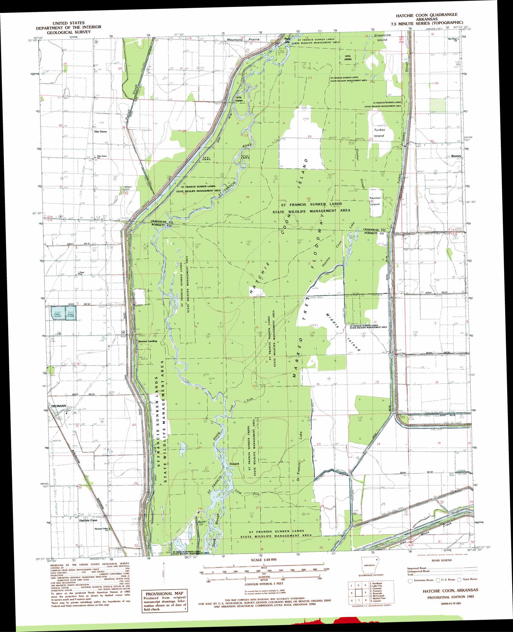
USGS Topo Quad 35090f4 - 1:24,000 scale
| Topo Map Name: | Hatchie Coon |
| USGS Topo Quad ID: | 35090f4 |
| Print Size: | ca. 21 1/4" wide x 27" high |
| Southeast Coordinates: | 35.625° N latitude / 90.375° W longitude |
| Map Center Coordinates: | 35.6875° N latitude / 90.4375° W longitude |
| U.S. State: | AR |
| Filename: | o35090f4.jpg |
| Download Map JPG Image: | Hatchie Coon topo map 1:24,000 scale |
| Map Type: | Topographic |
| Topo Series: | 7.5´ |
| Map Scale: | 1:24,000 |
| Source of Map Images: | United States Geological Survey (USGS) |
| Alternate Map Versions: |
Hatchie Coon AR 1983, updated 1984 Download PDF Buy paper map Hatchie Coon AR 2011 Download PDF Buy paper map Hatchie Coon AR 2014 Download PDF Buy paper map |
1:24,000 Topo Quads surrounding Hatchie Coon
Lorado |
Brookland |
Dixie |
Leachville |
Manila North |
Jonesboro |
Needham |
Lake City |
Caraway |
Manila South |
Greenfield |
Trumann |
Hatchie Coon |
Riverdale |
Etowah |
Harrisburg |
Mccormick |
Marked Tree |
Lepanto |
Joiner |
Cherry Valley East |
Monterey |
Joyland |
Tyronza |
Frenchmans Bayou |
> Back to 35090e1 at 1:100,000 scale
> Back to 35090a1 at 1:250,000 scale
> Back to U.S. Topo Maps home
Hatchie Coon topo map: Gazetteer
Hatchie Coon: Canals
Ditch Number 1 elevation 64m 209′Ditch Number 23 elevation 66m 216′
Ditch Number 31 elevation 64m 209′
Ditch Number 32 elevation 69m 226′
Ditch Number 33 elevation 67m 219′
Ditch Number 54 elevation 69m 226′
Ditch Number 55 elevation 68m 223′
Ditch Number 59 elevation 67m 219′
Ditch Number 60 elevation 64m 209′
Ditch Number 8 elevation 64m 209′
Hatchie Coon: Flats
Grapevine Island elevation 67m 219′Hatchie Coon Island elevation 64m 209′
Middle Island elevation 66m 216′
Panther Island elevation 64m 209′
Saint Francis Sunk Lands elevation 66m 216′
Turkey Island elevation 66m 216′
Hatchie Coon: Guts
Panther Slough elevation 65m 213′Turkey Island Slough elevation 65m 213′
Hatchie Coon: Populated Places
Bunney elevation 65m 213′Deep Landing elevation 66m 216′
Donnick elevation 66m 216′
Elm Grove elevation 66m 216′
Hatchie Coon elevation 68m 223′
Longwill elevation 66m 216′
Hatchie Coon: Streams
Lead Fork elevation 66m 216′Lead Fork elevation 65m 213′
Purcell Slough elevation 63m 206′
Right Hand Chute Little River elevation 68m 223′
Hatchie Coon: Swamps
Hatchie Coon Lake elevation 63m 206′Saint Francis Lake elevation 67m 219′
Hatchie Coon digital topo map on disk
Buy this Hatchie Coon topo map showing relief, roads, GPS coordinates and other geographical features, as a high-resolution digital map file on DVD: