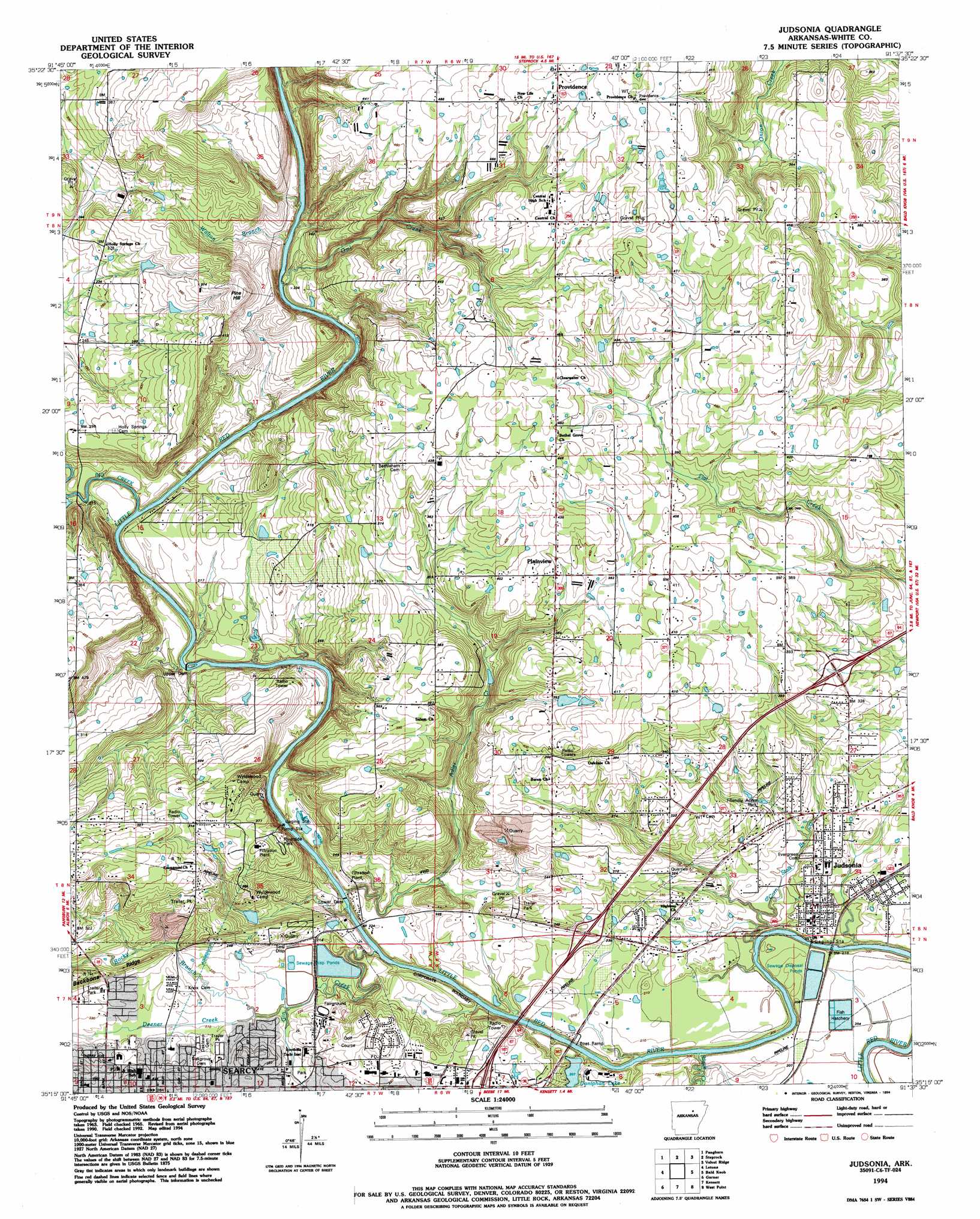
Judsonia Topo Map Arkansas
To zoom in, hover over the map of Judsonia
USGS Topo Quad 35091c6 - 1:24,000 scale
| Topo Map Name: | Judsonia |
| USGS Topo Quad ID: | 35091c6 |
| Print Size: | ca. 21 1/4" wide x 27" high |
| Southeast Coordinates: | 35.25° N latitude / 91.625° W longitude |
| Map Center Coordinates: | 35.3125° N latitude / 91.6875° W longitude |
| U.S. State: | AR |
| Filename: | o35091c6.jpg |
| Download Map JPG Image: | Judsonia topo map 1:24,000 scale |
| Map Type: | Topographic |
| Topo Series: | 7.5´ |
| Map Scale: | 1:24,000 |
| Source of Map Images: | United States Geological Survey (USGS) |
| Alternate Map Versions: |
Judsonia AR 1965, updated 1966 Download PDF Buy paper map Judsonia AR 1965, updated 1980 Download PDF Buy paper map Judsonia AR 1965, updated 1982 Download PDF Buy paper map Judsonia AR 1994, updated 1994 Download PDF Buy paper map Judsonia AR 2011 Download PDF Buy paper map Judsonia AR 2014 Download PDF Buy paper map |
1:24,000 Topo Quads surrounding Judsonia
Greers Ferry Dam |
Floral |
Pleasant Plains |
Huff |
Olyphant |
West Pangburn |
Pangburn |
Steprock |
Velvet Ridge |
Bradford |
Sidon |
Letona |
Judsonia |
Bald Knob |
Augusta Sw |
Floyd |
Garner |
Kensett |
West Point |
Georgetown |
Beebe |
Mcrae |
Walker |
Jasmine |
Gregory Sw |
> Back to 35091a1 at 1:100,000 scale
> Back to 35090a1 at 1:250,000 scale
> Back to U.S. Topo Maps home
Judsonia topo map: Gazetteer
Judsonia: Airports
White County Memorial Hospital Heliport elevation 73m 239′Judsonia: Bridges
Judsonia Bridge elevation 52m 170′Judsonia: Dams
Doniphan Lake Dam elevation 58m 190′Lower Dam elevation 56m 183′
Upper Dam elevation 58m 190′
Wyldewood Lake Dam elevation 115m 377′
Judsonia: Lakes
Doniphan Lake elevation 58m 190′Judsonia: Mines
Searcy Quarry elevation 101m 331′Judsonia: Parks
Friendly Acres Park elevation 71m 232′Kiwanis Park elevation 107m 351′
Lion Stadium elevation 67m 219′
Judsonia: Populated Places
Bee Rock elevation 113m 370′Clear Water (historical) elevation 148m 485′
Holly Springs elevation 84m 275′
Judsonia elevation 64m 209′
Plainview elevation 122m 400′
Providence elevation 156m 511′
Searcy elevation 78m 255′
Short (historical) elevation 88m 288′
Judsonia: Post Offices
Searcy Post Office elevation 74m 242′Judsonia: Reservoirs
Wyldewood Lake elevation 115m 377′Judsonia: Streams
Adler Creek elevation 63m 206′Big Creek elevation 67m 219′
Black Creek elevation 53m 173′
Corn Stalk Branch elevation 50m 164′
Deener Creek elevation 59m 193′
Gin Creek elevation 53m 173′
Owl Creek elevation 60m 196′
Rocky Branch elevation 60m 196′
Walton Branch elevation 60m 196′
Judsonia: Summits
Pine Hill elevation 138m 452′Judsonia digital topo map on disk
Buy this Judsonia topo map showing relief, roads, GPS coordinates and other geographical features, as a high-resolution digital map file on DVD: