Bradford Topo Map Arkansas
To zoom in, hover over the map of Bradford
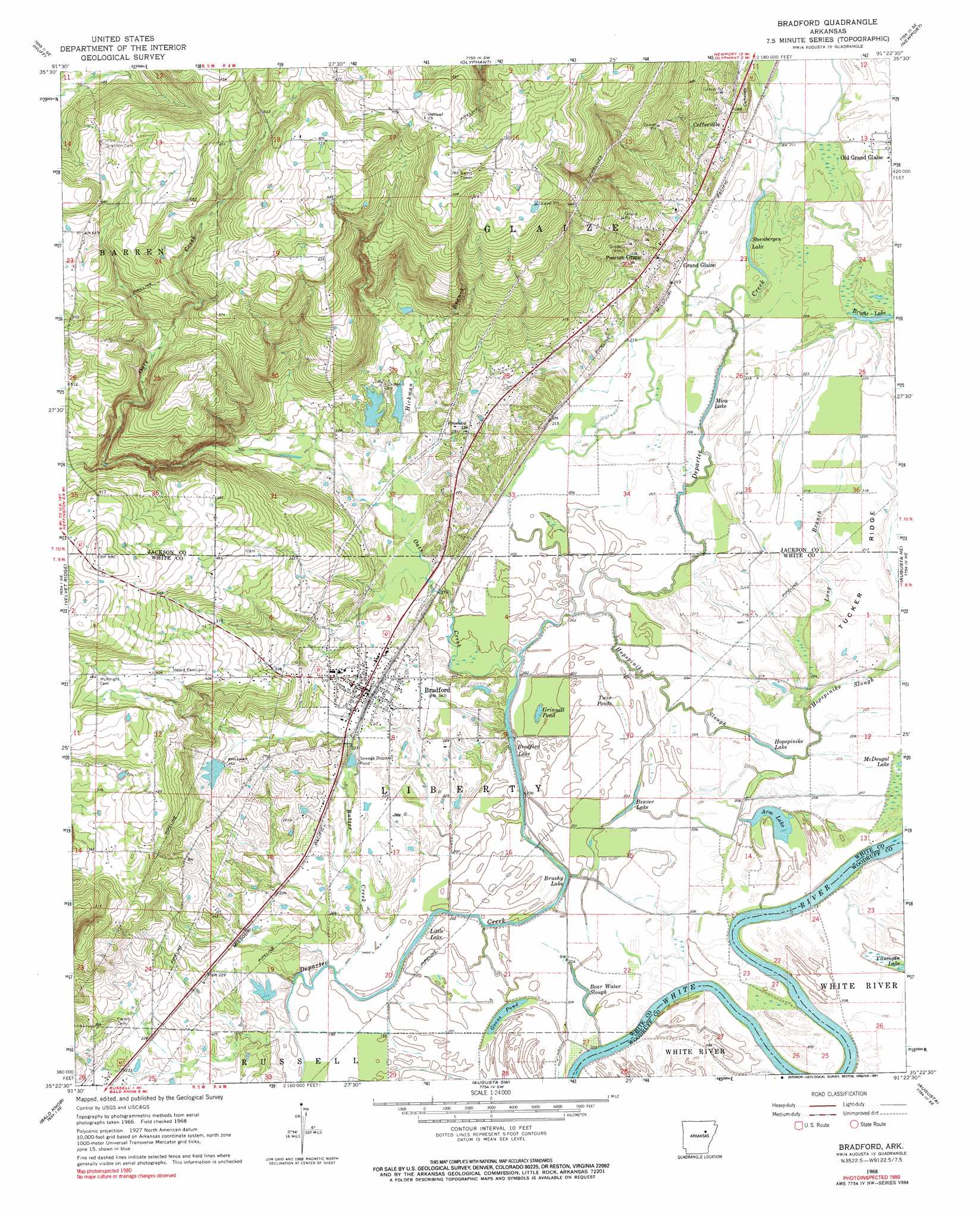
USGS Topo Quad 35091d4 - 1:24,000 scale
| Topo Map Name: | Bradford |
| USGS Topo Quad ID: | 35091d4 |
| Print Size: | ca. 21 1/4" wide x 27" high |
| Southeast Coordinates: | 35.375° N latitude / 91.375° W longitude |
| Map Center Coordinates: | 35.4375° N latitude / 91.4375° W longitude |
| U.S. State: | AR |
| Filename: | o35091d4.jpg |
| Download Map JPG Image: | Bradford topo map 1:24,000 scale |
| Map Type: | Topographic |
| Topo Series: | 7.5´ |
| Map Scale: | 1:24,000 |
| Source of Map Images: | United States Geological Survey (USGS) |
| Alternate Map Versions: |
Bradford AR 1968, updated 1970 Download PDF Buy paper map Bradford AR 1968, updated 1991 Download PDF Buy paper map Bradford AR 2011 Download PDF Buy paper map Bradford AR 2014 Download PDF Buy paper map |
1:24,000 Topo Quads surrounding Bradford
Jamestown |
Salado |
Newark |
Jacksonport |
Tuckerman |
Pleasant Plains |
Huff |
Olyphant |
Newport |
Auvergne |
Steprock |
Velvet Ridge |
Bradford |
Augusta Ne |
Tupelo |
Judsonia |
Bald Knob |
Augusta Sw |
Augusta |
Mccrory |
Kensett |
West Point |
Georgetown |
Gregory |
Grays |
> Back to 35091a1 at 1:100,000 scale
> Back to 35090a1 at 1:250,000 scale
> Back to U.S. Topo Maps home
Bradford topo map: Gazetteer
Bradford: Bends
Blackbird Bend elevation 59m 193′Brown Bend elevation 59m 193′
Dudley Dread elevation 60m 196′
Bradford: Channels
Raleigh Reach elevation 61m 200′Bradford: Dams
B C Smith Lake Dam elevation 72m 236′Masons Reservoir Dam elevation 73m 239′
Smith Lake One Dam elevation 79m 259′
Smith Lake Two Dam elevation 69m 226′
Bradford: Guts
Bear Water Slough elevation 65m 213′Bradford: Lakes
Arm Lake elevation 58m 190′Beaver Lake elevation 62m 203′
Bradford Lake elevation 58m 190′
Bright Lake elevation 64m 209′
Brushy Lake elevation 62m 203′
Goose Pond elevation 61m 200′
Grinnell Pond elevation 62m 203′
Hopspinike Lake elevation 62m 203′
Little Lake elevation 61m 200′
Mica Lake elevation 63m 206′
Steenbergen Lake elevation 66m 216′
Bradford: Populated Places
Bradford elevation 78m 255′Coffeeville elevation 73m 239′
Grand Glaise elevation 89m 291′
Old Grand Glaise elevation 67m 219′
Possum Grape elevation 76m 249′
Bradford: Reservoirs
Masons Reservoir elevation 73m 239′Smith Lake elevation 72m 236′
Smith Lake One elevation 79m 259′
Smith Lake Two elevation 69m 226′
Bradford: Ridges
Tucker Ridge elevation 67m 219′Bradford: Streams
Butter Creek elevation 62m 203′Hickman Branch elevation 65m 213′
Hopspinike Slough elevation 64m 209′
Long Branch elevation 64m 209′
Oats Creek elevation 62m 203′
Bradford: Swamps
Twin Ponds elevation 62m 203′Bradford digital topo map on disk
Buy this Bradford topo map showing relief, roads, GPS coordinates and other geographical features, as a high-resolution digital map file on DVD: