Pangburn Topo Map Arkansas
To zoom in, hover over the map of Pangburn
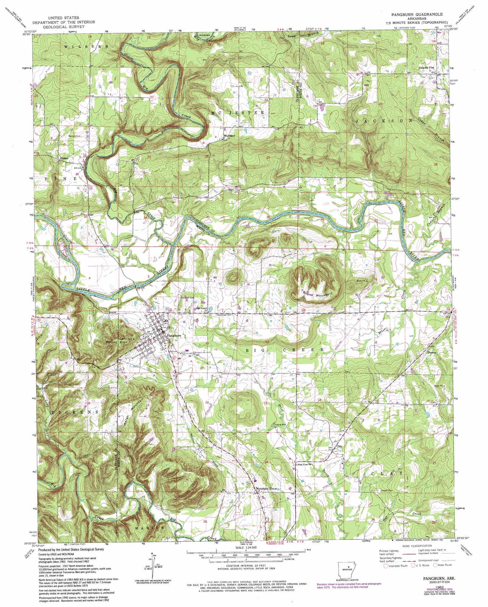
USGS Topo Quad 35091d7 - 1:24,000 scale
| Topo Map Name: | Pangburn |
| USGS Topo Quad ID: | 35091d7 |
| Print Size: | ca. 21 1/4" wide x 27" high |
| Southeast Coordinates: | 35.375° N latitude / 91.75° W longitude |
| Map Center Coordinates: | 35.4375° N latitude / 91.8125° W longitude |
| U.S. State: | AR |
| Filename: | o35091d7.jpg |
| Download Map JPG Image: | Pangburn topo map 1:24,000 scale |
| Map Type: | Topographic |
| Topo Series: | 7.5´ |
| Map Scale: | 1:24,000 |
| Source of Map Images: | United States Geological Survey (USGS) |
| Alternate Map Versions: |
Pangburn AR 1962, updated 1964 Download PDF Buy paper map Pangburn AR 1962, updated 1976 Download PDF Buy paper map Pangburn AR 1962, updated 1993 Download PDF Buy paper map Pangburn AR 2011 Download PDF Buy paper map Pangburn AR 2014 Download PDF Buy paper map |
1:24,000 Topo Quads surrounding Pangburn
Prim |
Drasco |
Concord |
Jamestown |
Salado |
Brownsville |
Greers Ferry Dam |
Floral |
Pleasant Plains |
Huff |
Heber Springs |
West Pangburn |
Pangburn |
Steprock |
Velvet Ridge |
Rose Bud |
Sidon |
Letona |
Judsonia |
Bald Knob |
Mount Vernon |
Floyd |
Garner |
Kensett |
West Point |
> Back to 35091a1 at 1:100,000 scale
> Back to 35090a1 at 1:250,000 scale
> Back to U.S. Topo Maps home
Pangburn topo map: Gazetteer
Pangburn: Populated Places
Clay elevation 82m 269′Dewey elevation 96m 314′
Hickory Flat elevation 191m 626′
Hiram elevation 130m 426′
McJester elevation 184m 603′
Mountain Home elevation 93m 305′
Pangburn elevation 109m 357′
Rainbow Island elevation 80m 262′
Pangburn: Streams
Big Creek elevation 75m 246′Brier Creek elevation 66m 216′
Cedar Branch elevation 93m 305′
Long Branch elevation 92m 301′
Pangburn: Summits
Bruce Mountain elevation 168m 551′Marsh Mountain elevation 189m 620′
Mount Zion elevation 191m 626′
Pangburn digital topo map on disk
Buy this Pangburn topo map showing relief, roads, GPS coordinates and other geographical features, as a high-resolution digital map file on DVD: