Grubbs Topo Map Arkansas
To zoom in, hover over the map of Grubbs
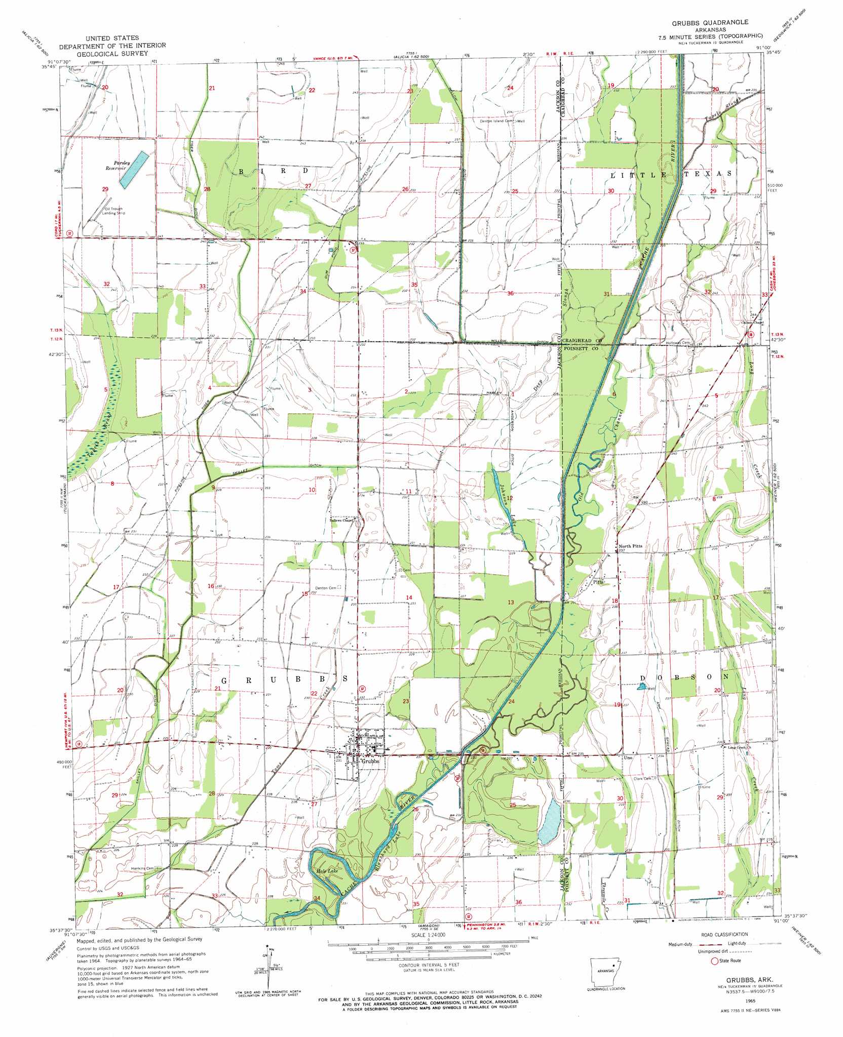
USGS Topo Quad 35091f1 - 1:24,000 scale
| Topo Map Name: | Grubbs |
| USGS Topo Quad ID: | 35091f1 |
| Print Size: | ca. 21 1/4" wide x 27" high |
| Southeast Coordinates: | 35.625° N latitude / 91° W longitude |
| Map Center Coordinates: | 35.6875° N latitude / 91.0625° W longitude |
| U.S. State: | AR |
| Filename: | o35091f1.jpg |
| Download Map JPG Image: | Grubbs topo map 1:24,000 scale |
| Map Type: | Topographic |
| Topo Series: | 7.5´ |
| Map Scale: | 1:24,000 |
| Source of Map Images: | United States Geological Survey (USGS) |
| Alternate Map Versions: |
Grubbs AR 1965, updated 1966 Download PDF Buy paper map Grubbs AR 2011 Download PDF Buy paper map Grubbs AR 2014 Download PDF Buy paper map |
1:24,000 Topo Quads surrounding Grubbs
Strawberry |
Strangers Home |
Alicia |
Podo Creek |
Bono |
Cord |
Swifton West |
Swifton East |
Cash |
Herman |
Jacksonport |
Tuckerman |
Grubbs |
Risher |
Otwell |
Newport |
Auvergne |
Amagon |
Weiner |
Powers Slough |
Augusta Ne |
Tupelo |
Beedeville |
Hickory Ridge |
Cherry Valley West |
> Back to 35091e1 at 1:100,000 scale
> Back to 35090a1 at 1:250,000 scale
> Back to U.S. Topo Maps home
Grubbs topo map: Gazetteer
Grubbs: Airports
Oil Trough Landing Strip elevation 70m 229′Grubbs: Canals
Ash Spread Ditch elevation 71m 232′Gum Pond Ditch elevation 67m 219′
Harley Anderson Ditch elevation 67m 219′
Skillet Ditch elevation 69m 226′
Tiger Ditch elevation 69m 226′
Grubbs: Guts
Tupelo Slough elevation 70m 229′Grubbs: Lakes
Blanchard Lake elevation 69m 226′Hale Lake elevation 68m 223′
Johnson Lake elevation 69m 226′
Grubbs: Populated Places
Chilson elevation 71m 232′Credit (historical) elevation 70m 229′
Grubbs elevation 70m 229′
Hale (historical) elevation 69m 226′
North Pitts elevation 70m 229′
Pitts elevation 71m 232′
Tuscany (historical) elevation 72m 236′
Uno elevation 71m 232′
Grubbs: Reservoirs
Parsley Reservoir elevation 70m 229′Grubbs: Streams
Deep Slough elevation 70m 229′Old Channel Cache River elevation 68m 223′
Grubbs digital topo map on disk
Buy this Grubbs topo map showing relief, roads, GPS coordinates and other geographical features, as a high-resolution digital map file on DVD: