Mount Pleasant Topo Map Arkansas
To zoom in, hover over the map of Mount Pleasant
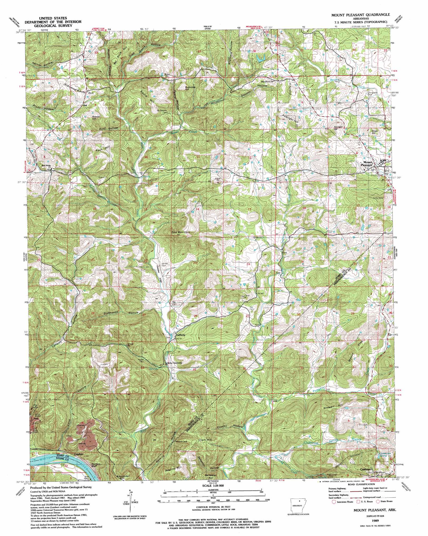
USGS Topo Quad 35091h7 - 1:24,000 scale
| Topo Map Name: | Mount Pleasant |
| USGS Topo Quad ID: | 35091h7 |
| Print Size: | ca. 21 1/4" wide x 27" high |
| Southeast Coordinates: | 35.875° N latitude / 91.75° W longitude |
| Map Center Coordinates: | 35.9375° N latitude / 91.8125° W longitude |
| U.S. State: | AR |
| Filename: | o35091h7.jpg |
| Download Map JPG Image: | Mount Pleasant topo map 1:24,000 scale |
| Map Type: | Topographic |
| Topo Series: | 7.5´ |
| Map Scale: | 1:24,000 |
| Source of Map Images: | United States Geological Survey (USGS) |
| Alternate Map Versions: |
Mt Pleasant AR 1942, updated 1956 Download PDF Buy paper map Mt Pleasant AR 1942, updated 1974 Download PDF Buy paper map Mt Pleasant AR 1942, updated 1979 Download PDF Buy paper map Mount Pleasant AR 1989, updated 1989 Download PDF Buy paper map Mount Pleasant AR 2011 Download PDF Buy paper map Mount Pleasant AR 2014 Download PDF Buy paper map |
1:24,000 Topo Quads surrounding Mount Pleasant
Pineville |
Oxford |
Franklin |
Myron |
Ash Flat |
Boswell |
Melbourne |
Zion |
Sidney |
Evening Shade |
Sylamore |
Guion |
Mount Pleasant |
Sandtown |
Cave City |
Mountain View |
Marcella |
Bethesda |
Batesville |
Sulphur Rock |
Prim |
Drasco |
Concord |
Jamestown |
Salado |
> Back to 35091e1 at 1:100,000 scale
> Back to 35090a1 at 1:250,000 scale
> Back to U.S. Topo Maps home
Mount Pleasant topo map: Gazetteer
Mount Pleasant: Airports
Spring Valley Ranch Landing Strip elevation 115m 377′Mount Pleasant: Cliffs
Painters Bluff elevation 231m 757′Mount Pleasant: Mines
Adler Hollow Mine elevation 187m 613′Anderson Prospect elevation 231m 757′
Barksdale Mine elevation 134m 439′
Bevans Prospect elevation 178m 583′
Bob Wilson Prospect elevation 208m 682′
Breeden Prospect elevation 208m 682′
C L Sanders Prospect elevation 189m 620′
Calaway Prospect elevation 206m 675′
Caraway Prospect elevation 161m 528′
Cave Hill Mine elevation 211m 692′
Clubhouse Extension Mines (historical) elevation 237m 777′
Clubhouse Mine elevation 207m 679′
Cummins Hollow Mine elevation 136m 446′
Cutter Mine elevation 216m 708′
E D Winkle Prospect elevation 182m 597′
E Winkle Prospect elevation 214m 702′
Earl Collie Mine elevation 125m 410′
Edwards Mine elevation 159m 521′
Ellen Clark Prospect elevation 158m 518′
Felts Prospect elevation 191m 626′
H J Ray Prospect elevation 192m 629′
H M Tate Prospect elevation 169m 554′
Haddock Prospect elevation 222m 728′
Hall Prospect elevation 222m 728′
Hankins Hollow Mine elevation 139m 456′
Helm Prospect elevation 170m 557′
Hollawell Prospect elevation 203m 666′
Izard Mine elevation 209m 685′
J P Barnes Prospect elevation 200m 656′
J R Dobson Prospect elevation 194m 636′
Johnson Hill Mine elevation 144m 472′
Klondike Mine elevation 234m 767′
L B Ray Prospect elevation 224m 734′
L J Weaver Mine elevation 238m 780′
Lewis Prospect elevation 247m 810′
Love Prospect elevation 174m 570′
M E Wilson Prospect elevation 180m 590′
Manganese Field Mine elevation 166m 544′
McConnell Mine elevation 214m 702′
Miller Prospect elevation 218m 715′
Moser Prospect elevation 204m 669′
Mount Etna Mine elevation 190m 623′
Neill Prospect elevation 206m 675′
O'Gilsby Prospect elevation 248m 813′
Page Mine elevation 189m 620′
Pittman Mines elevation 192m 629′
Pugh Mine elevation 202m 662′
Rudolph Prospect elevation 216m 708′
Ruminer Rough Mine elevation 155m 508′
Salt Peter Hill Mine elevation 145m 475′
Sand Field Mine elevation 157m 515′
Sand Field Prospect elevation 152m 498′
Sanders Prospect elevation 210m 688′
Skelton Hill Mine elevation 215m 705′
Skelton-Hanford Prospect elevation 179m 587′
Sterrett Mine elevation 226m 741′
T C Winkle Prospect elevation 130m 426′
T M Tate Mine elevation 110m 360′
Verna Mine elevation 199m 652′
W A King Mine elevation 203m 666′
W K Tate Prospect elevation 218m 715′
W L Johnson Prospect elevation 210m 688′
Williamson-Gulley Prospect elevation 186m 610′
Wolford Mine elevation 204m 669′
Mount Pleasant: Populated Places
Crocker elevation 94m 308′Edmonson (historical) elevation 235m 770′
Gid elevation 188m 616′
Lafferty elevation 117m 383′
Mount Pleasant elevation 190m 623′
Mount Pleasant: Springs
Blowing Cave Spring elevation 173m 567′Clubhouse Spring elevation 191m 626′
Mount Pleasant: Streams
Bailey Brooks Branch elevation 122m 400′Blowing Cave Creek elevation 101m 331′
Brown Creek elevation 132m 433′
Clubhouse Spring Branch elevation 113m 370′
Colley Branch elevation 146m 479′
Macedonia Creek elevation 140m 459′
Pumpkin Creek elevation 110m 360′
Turner Creek elevation 132m 433′
Mount Pleasant: Summits
Adeline Hill elevation 225m 738′Bat Knob Hill elevation 224m 734′
Buckalew Hill elevation 229m 751′
Clark Hill elevation 239m 784′
Craig Hill elevation 250m 820′
Egard Hill elevation 242m 793′
Fulbright Hill elevation 261m 856′
Jeff Hill elevation 214m 702′
Mount Etna elevation 221m 725′
Negro Hill elevation 236m 774′
Pine Mountain elevation 291m 954′
Reeves Hill elevation 243m 797′
Rout Hill elevation 236m 774′
Saltpeter Hill elevation 193m 633′
Shaw Hill elevation 255m 836′
Standing Rocks elevation 204m 669′
Stewart Hill elevation 243m 797′
Younger Hill elevation 264m 866′
Mount Pleasant: Valleys
Adler Hollow elevation 109m 357′Bryant Hollow elevation 149m 488′
Chappel Hollow elevation 171m 561′
Crosby Hollow elevation 110m 360′
Cummins Hollow elevation 99m 324′
Dan Hollow elevation 164m 538′
Dilliner Hollow elevation 165m 541′
Egard Hollow elevation 147m 482′
Groove Hollow elevation 152m 498′
Hankins Hollow elevation 93m 305′
Love Hollow elevation 86m 282′
Macedonia Hollow elevation 168m 551′
Moser Hollow elevation 171m 561′
Palmer Hollow elevation 155m 508′
Pine Grove Hollow elevation 146m 479′
Rout Hollow elevation 138m 452′
Saltpeter Hollow elevation 109m 357′
Sheffield Hollow elevation 168m 551′
Stillhouse Hollow elevation 114m 374′
Waterfall Hollow elevation 188m 616′
Mount Pleasant digital topo map on disk
Buy this Mount Pleasant topo map showing relief, roads, GPS coordinates and other geographical features, as a high-resolution digital map file on DVD: