Vilonia Topo Map Arkansas
To zoom in, hover over the map of Vilonia
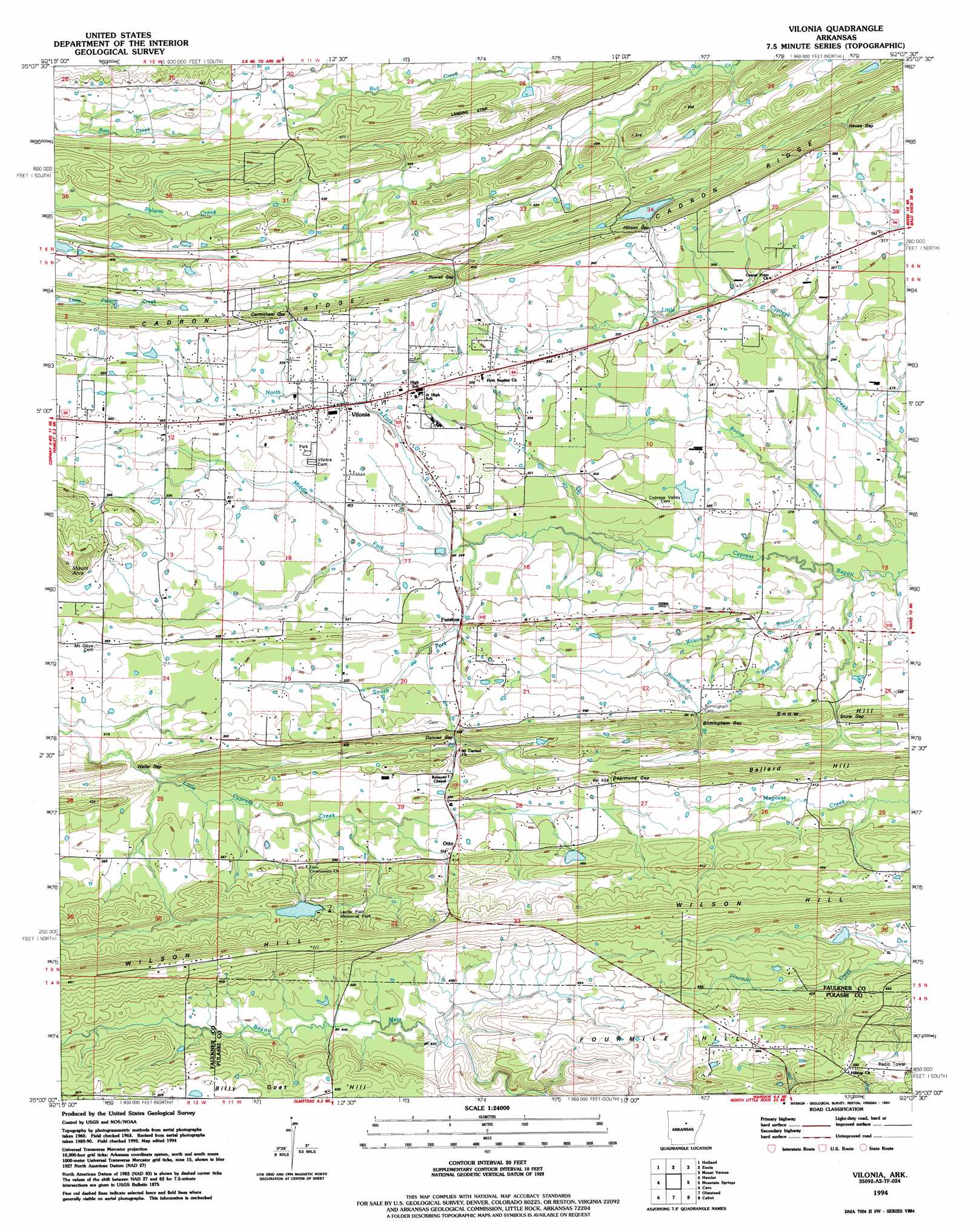
USGS Topo Quad 35092a2 - 1:24,000 scale
| Topo Map Name: | Vilonia |
| USGS Topo Quad ID: | 35092a2 |
| Print Size: | ca. 21 1/4" wide x 27" high |
| Southeast Coordinates: | 35° N latitude / 92.125° W longitude |
| Map Center Coordinates: | 35.0625° N latitude / 92.1875° W longitude |
| U.S. State: | AR |
| Filename: | o35092a2.jpg |
| Download Map JPG Image: | Vilonia topo map 1:24,000 scale |
| Map Type: | Topographic |
| Topo Series: | 7.5´ |
| Map Scale: | 1:24,000 |
| Source of Map Images: | United States Geological Survey (USGS) |
| Alternate Map Versions: |
Vilonia AR 1963, updated 1964 Download PDF Buy paper map Vilonia AR 1963, updated 1976 Download PDF Buy paper map Vilonia AR 1963, updated 1982 Download PDF Buy paper map Vilonia AR 1994, updated 1994 Download PDF Buy paper map Vilonia AR 2011 Download PDF Buy paper map Vilonia AR 2014 Download PDF Buy paper map |
1:24,000 Topo Quads surrounding Vilonia
Damascus |
Guy |
Barney |
Rose Bud |
Sidon |
Greenbrier |
Holland |
Enola |
Mount Vernon |
Floyd |
Conway |
Hamlet |
Vilonia |
Mountain Springs |
Beebe |
Mayflower |
Cato |
Olmstead |
Cabot |
Oak Grove |
Pinnacle Mountain |
North Little Rock |
Mcalmont |
Jacksonville |
Lonoke |
> Back to 35092a1 at 1:100,000 scale
> Back to 35092a1 at 1:250,000 scale
> Back to U.S. Topo Maps home
Vilonia topo map: Gazetteer
Vilonia: Airports
Vilonia Airport elevation 173m 567′Vilonia: Dams
Bailey Lake Dam elevation 142m 465′Lake Ola-Dale Dam elevation 108m 354′
Williams Lake Dam elevation 113m 370′
Vilonia: Gaps
Birmingham Gap elevation 99m 324′Carmichael Gap elevation 127m 416′
Dearmond Gap elevation 130m 426′
Duncan Gap elevation 103m 337′
Hinson Gap elevation 103m 337′
House Gap elevation 109m 357′
Powell Gap elevation 113m 370′
Snow Gap elevation 98m 321′
Waller Gap elevation 97m 318′
Vilonia: Populated Places
Center Point elevation 92m 301′Duncans Gap (historical) elevation 102m 334′
Funston elevation 101m 331′
Otto elevation 125m 410′
Vilonia elevation 96m 314′
Vilonia: Reservoirs
Bailey Lake elevation 142m 465′Lake Ola elevation 108m 354′
Williams Lake elevation 113m 370′
Vilonia: Streams
Birmingham Branch elevation 90m 295′Middle Fork Cypress Bayou elevation 88m 288′
North Fork Cypress Bayou elevation 87m 285′
Rattan Branch elevation 81m 265′
South Fork Cypress Bayou elevation 87m 285′
Wilson Branch elevation 81m 265′
Vilonia: Summits
Ballard Hill elevation 151m 495′Billy Goat Hill elevation 190m 623′
Mount Arva elevation 170m 557′
Snow Hill elevation 122m 400′
Wilson Hill elevation 187m 613′
Vilonia digital topo map on disk
Buy this Vilonia topo map showing relief, roads, GPS coordinates and other geographical features, as a high-resolution digital map file on DVD: