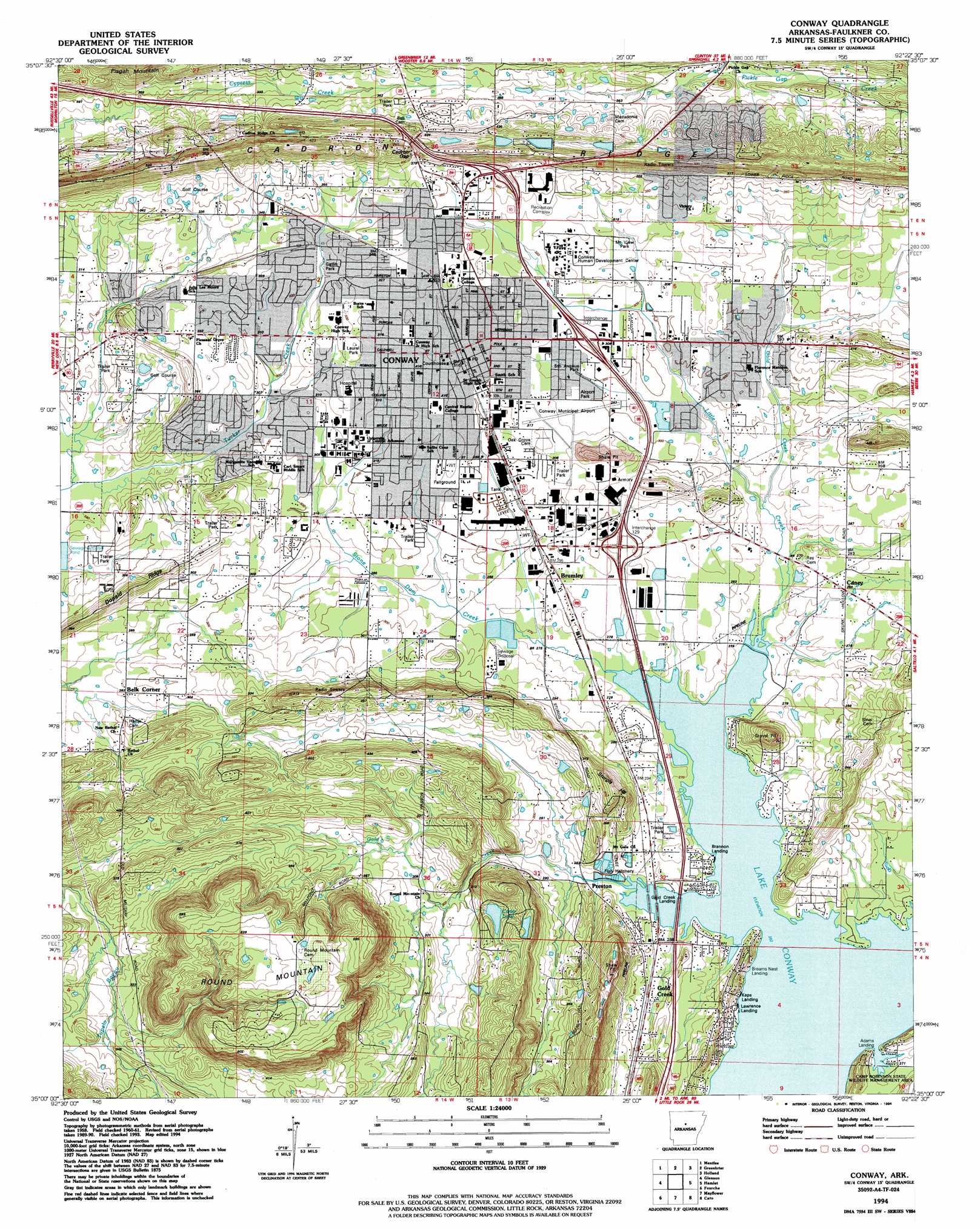
Conway Topo Map Arkansas
To zoom in, hover over the map of Conway
USGS Topo Quad 35092a4 - 1:24,000 scale
| Topo Map Name: | Conway |
| USGS Topo Quad ID: | 35092a4 |
| Print Size: | ca. 21 1/4" wide x 27" high |
| Southeast Coordinates: | 35° N latitude / 92.375° W longitude |
| Map Center Coordinates: | 35.0625° N latitude / 92.4375° W longitude |
| U.S. State: | AR |
| Filename: | o35092a4.jpg |
| Download Map JPG Image: | Conway topo map 1:24,000 scale |
| Map Type: | Topographic |
| Topo Series: | 7.5´ |
| Map Scale: | 1:24,000 |
| Source of Map Images: | United States Geological Survey (USGS) |
| Alternate Map Versions: |
Conway AR 1961, updated 1963 Download PDF Buy paper map Conway AR 1961, updated 1973 Download PDF Buy paper map Conway AR 1961, updated 1980 Download PDF Buy paper map Conway AR 1961, updated 1982 Download PDF Buy paper map Conway AR 1994, updated 1994 Download PDF Buy paper map Conway AR 2011 Download PDF Buy paper map Conway AR 2014 Download PDF Buy paper map |
1:24,000 Topo Quads surrounding Conway
Solgohachia |
Springfield |
Damascus |
Guy |
Barney |
Morrilton East |
Menifee |
Greenbrier |
Holland |
Enola |
Houston |
Gleason |
Conway |
Hamlet |
Vilonia |
Martindale |
Fourche |
Mayflower |
Cato |
Olmstead |
Fourche Sw |
Ferndale |
Pinnacle Mountain |
North Little Rock |
Mcalmont |
> Back to 35092a1 at 1:100,000 scale
> Back to 35092a1 at 1:250,000 scale
> Back to U.S. Topo Maps home
Conway topo map: Gazetteer
Conway: Airports
Conway Regional Hospital Heliport elevation 99m 324′Dennis F Cantrell Field elevation 98m 321′
Conway: Crossings
Interchange 124 elevation 122m 400′Interchange 125 elevation 112m 367′
Interchange 127 elevation 102m 334′
Interchange 129 elevation 92m 301′
Conway: Dams
Carter Lake Dam elevation 104m 341′Days Lake Dam elevation 125m 410′
Gentry Lake Dam elevation 138m 452′
Robbins Lake Dam elevation 133m 436′
Conway: Gaps
Cadron Gap elevation 126m 413′Conway: Lakes
Adams Lake (historical) elevation 81m 265′Gold Lake (historical) elevation 81m 265′
Conway: Parks
Airport Park elevation 95m 311′Estes Stadium elevation 94m 308′
Fifth Avenue Park elevation 94m 308′
Gatlin Park elevation 98m 321′
Laurel Park elevation 100m 328′
Mountain View Park elevation 94m 308′
Robert W Young Memorial Stadium elevation 100m 328′
Conway: Populated Places
Belk Corner elevation 88m 288′Brumley elevation 88m 288′
Caney elevation 88m 288′
Conway elevation 94m 308′
Gold Creek elevation 90m 295′
Gold Lake Estates elevation 81m 265′
Preston elevation 82m 269′
Rolling Hills elevation 116m 380′
Round Mountain elevation 94m 308′
Conway: Post Offices
Conway Post Office elevation 94m 308′Conway: Reservoirs
Carter Lake elevation 104m 341′Days Lake elevation 125m 410′
Gentry Lake elevation 138m 452′
Robins Lake elevation 133m 436′
Conway: Ridges
Donald Ridge elevation 105m 344′Conway: Streams
Gold Creek elevation 83m 272′Gold Creek elevation 81m 265′
Little Creek elevation 80m 262′
Stone Dam Creek elevation 81m 265′
Conway: Summits
Round Mountain elevation 181m 593′Sturgis Hill elevation 120m 393′
Conway digital topo map on disk
Buy this Conway topo map showing relief, roads, GPS coordinates and other geographical features, as a high-resolution digital map file on DVD: