Morrilton East Topo Map Arkansas
To zoom in, hover over the map of Morrilton East
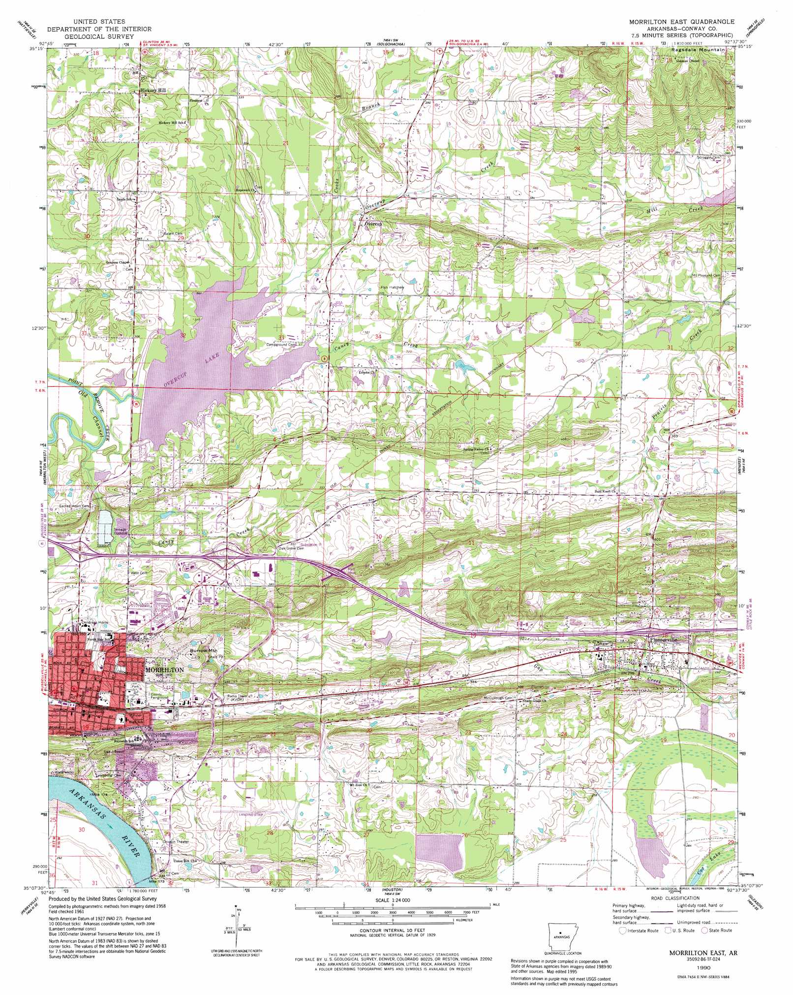
USGS Topo Quad 35092b6 - 1:24,000 scale
| Topo Map Name: | Morrilton East |
| USGS Topo Quad ID: | 35092b6 |
| Print Size: | ca. 21 1/4" wide x 27" high |
| Southeast Coordinates: | 35.125° N latitude / 92.625° W longitude |
| Map Center Coordinates: | 35.1875° N latitude / 92.6875° W longitude |
| U.S. State: | AR |
| Filename: | o35092b6.jpg |
| Download Map JPG Image: | Morrilton East topo map 1:24,000 scale |
| Map Type: | Topographic |
| Topo Series: | 7.5´ |
| Map Scale: | 1:24,000 |
| Source of Map Images: | United States Geological Survey (USGS) |
| Alternate Map Versions: |
Morrilton East AR 1961, updated 1962 Download PDF Buy paper map Morrilton East AR 1961, updated 1973 Download PDF Buy paper map Morrilton East AR 1961, updated 1982 Download PDF Buy paper map Morrilton East AR 1990, updated 1995 Download PDF Buy paper map Morrilton East AR 2011 Download PDF Buy paper map Morrilton East AR 2014 Download PDF Buy paper map |
1:24,000 Topo Quads surrounding Morrilton East
Hector |
Jerusalem |
Cleveland |
Formosa |
Bee Branch |
Moreland |
Hattieville |
Solgohachia |
Springfield |
Damascus |
Atkins |
Morrilton West |
Morrilton East |
Menifee |
Greenbrier |
Adona |
Perryville |
Houston |
Gleason |
Conway |
Aplin |
Thornburg |
Martindale |
Fourche |
Mayflower |
> Back to 35092a1 at 1:100,000 scale
> Back to 35092a1 at 1:250,000 scale
> Back to U.S. Topo Maps home
Morrilton East topo map: Gazetteer
Morrilton East: Airports
Conway County Hospital Heliport elevation 113m 370′Morrilton Municipal Airport elevation 95m 311′
Morrilton East: Crossings
Interchange 107 elevation 97m 318′Interchange 108 elevation 109m 357′
Interchange 112 elevation 95m 311′
Morrilton East: Dams
Lake Overcup Dam elevation 87m 285′Morrilton Sewage Lake Dam elevation 95m 311′
Morrilton East: Populated Places
Deerwood elevation 98m 321′Hickory Hill elevation 105m 344′
Lewisburg elevation 95m 311′
Morrilton elevation 118m 387′
North Hills Subdivision elevation 111m 364′
Northview Subdivision elevation 98m 321′
Overcup elevation 104m 341′
Plumerville elevation 90m 295′
Morrilton East: Post Offices
Morrilton Post Office elevation 116m 380′Morrilton East: Reservoirs
Lake Overcup elevation 87m 285′Morrilton Sewage Lake elevation 95m 311′
Morrilton East: Streams
Caney Creek elevation 85m 278′Caney Creek elevation 90m 295′
Cooks Branch elevation 95m 311′
Overcup Creek elevation 88m 288′
Morrilton East: Summits
Burrow Mountain elevation 185m 606′Morrilton East digital topo map on disk
Buy this Morrilton East topo map showing relief, roads, GPS coordinates and other geographical features, as a high-resolution digital map file on DVD: