Damascus Topo Map Arkansas
To zoom in, hover over the map of Damascus
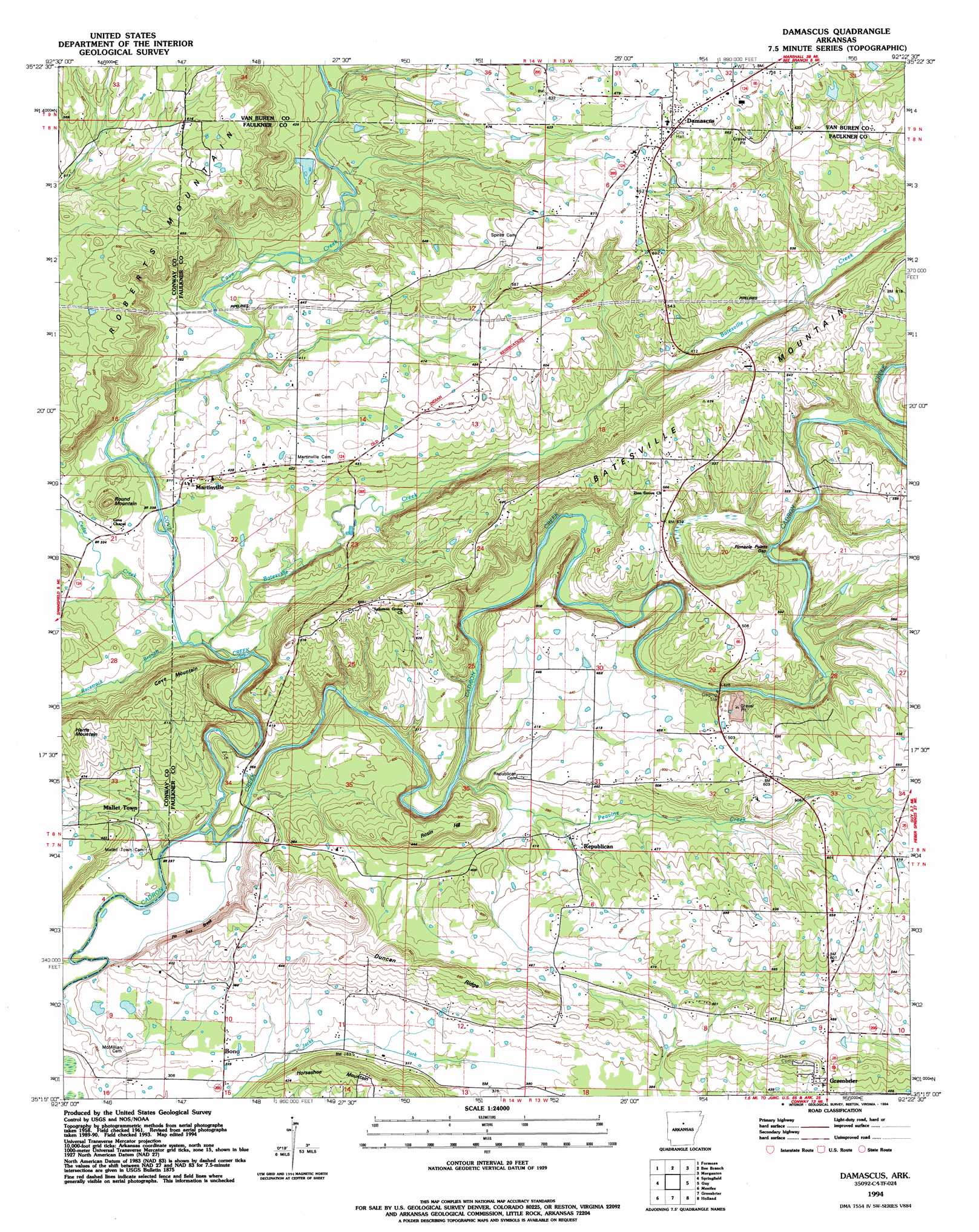
USGS Topo Quad 35092c4 - 1:24,000 scale
| Topo Map Name: | Damascus |
| USGS Topo Quad ID: | 35092c4 |
| Print Size: | ca. 21 1/4" wide x 27" high |
| Southeast Coordinates: | 35.25° N latitude / 92.375° W longitude |
| Map Center Coordinates: | 35.3125° N latitude / 92.4375° W longitude |
| U.S. State: | AR |
| Filename: | o35092c4.jpg |
| Download Map JPG Image: | Damascus topo map 1:24,000 scale |
| Map Type: | Topographic |
| Topo Series: | 7.5´ |
| Map Scale: | 1:24,000 |
| Source of Map Images: | United States Geological Survey (USGS) |
| Alternate Map Versions: |
Damascus AR 1961, updated 1966 Download PDF Buy paper map Damascus AR 1961, updated 1979 Download PDF Buy paper map Damascus AR 1961, updated 1979 Download PDF Buy paper map Damascus AR 1994, updated 1994 Download PDF Buy paper map Damascus AR 2011 Download PDF Buy paper map Damascus AR 2014 Download PDF Buy paper map |
1:24,000 Topo Quads surrounding Damascus
Rex |
Scotland |
Clinton |
Fairfield Bay |
Greers Ferry |
Cleveland |
Formosa |
Bee Branch |
Morganton |
Quitman |
Solgohachia |
Springfield |
Damascus |
Guy |
Barney |
Morrilton East |
Menifee |
Greenbrier |
Holland |
Enola |
Houston |
Gleason |
Conway |
Hamlet |
Vilonia |
> Back to 35092a1 at 1:100,000 scale
> Back to 35092a1 at 1:250,000 scale
> Back to U.S. Topo Maps home
Damascus topo map: Gazetteer
Damascus: Bridges
Fishtrap Bridge elevation 87m 285′Damascus: Capes
Long Point elevation 126m 413′Damascus: Cliffs
Pin Oak Break elevation 125m 410′Damascus: Crossings
Mallet Ford elevation 84m 275′Quinn Ford elevation 101m 331′
Damascus: Gaps
Pinnacle Point Gap elevation 124m 406′Damascus: Populated Places
Bono elevation 99m 324′Damascus elevation 211m 692′
Martinville elevation 120m 393′
Pinnacle Springs (historical) elevation 174m 570′
Republican elevation 110m 360′
Twin Groves elevation 113m 370′
Damascus: Ridges
Duncan Ridge elevation 164m 538′Damascus: Streams
Batesville Creek elevation 92m 301′Cedar Creek elevation 97m 318′
Cove Creek elevation 84m 275′
Hatcher Branch elevation 142m 465′
Peavine Creek elevation 97m 318′
Racetrack Branch elevation 93m 305′
Shilling Branch elevation 102m 334′
Damascus: Summits
Cove Mountain elevation 186m 610′Harris Mountain elevation 190m 623′
Rosin Hill elevation 165m 541′
Round Mountain elevation 135m 442′
Damascus digital topo map on disk
Buy this Damascus topo map showing relief, roads, GPS coordinates and other geographical features, as a high-resolution digital map file on DVD: