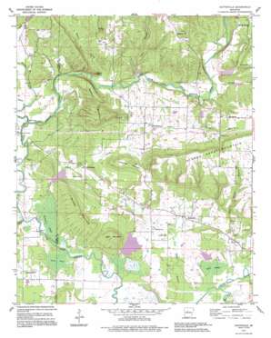
Hattieville Topo Map Arkansas
To zoom in, hover over the map of Hattieville
USGS Topo Quad 35092c7 - 1:24,000 scale
| Topo Map Name: | Hattieville |
| USGS Topo Quad ID: | 35092c7 |
| Print Size: | ca. 21 1/4" wide x 27" high |
| Southeast Coordinates: | 35.25° N latitude / 92.75° W longitude |
| Map Center Coordinates: | 35.3125° N latitude / 92.8125° W longitude |
| U.S. State: | AR |
| Filename: | o35092c7.jpg |
| Download Map JPG Image: | Hattieville topo map 1:24,000 scale |
| Map Type: | Topographic |
| Topo Series: | 7.5´ |
| Map Scale: | 1:24,000 |
| Source of Map Images: | United States Geological Survey (USGS) |
| Alternate Map Versions: |
Hattieville AR 1962, updated 1963 Download PDF Buy paper map Hattieville AR 1962, updated 1977 Download PDF Buy paper map Hattieville AR 1991, updated 1995 Download PDF Buy paper map Hattieville AR 2011 Download PDF Buy paper map Hattieville AR 2014 Download PDF Buy paper map |
1:24,000 Topo Quads surrounding Hattieville
> Back to 35092a1 at 1:100,000 scale
> Back to 35092a1 at 1:250,000 scale
> Back to U.S. Topo Maps home
Hattieville topo map: Gazetteer
Hattieville: Bridges
Burnetts Bridge elevation 97m 318′Hackers Bridge elevation 94m 308′
Prim Bridge elevation 91m 298′
Hattieville: Dams
Cargile Lake Dam elevation 96m 314′East Fork Point Remove Site 11 Dam elevation 107m 351′
West Fork Point Remove Creek Site 12 Dam elevation 126m 413′
West Fork Point Remove Creek Site 13 Dam elevation 125m 410′
West Fork Point Remove Creek Site 14 Dam elevation 139m 456′
West Fork Point Remove Creek Site 15 Dam elevation 147m 482′
West Fork Point Remove Creek Site 16 Dam elevation 96m 314′
Hattieville: Oilfields
Old Hickory Gas Field elevation 155m 508′Hattieville: Populated Places
Happy Bend elevation 97m 318′Hattieville elevation 101m 331′
Macedonia elevation 166m 544′
Old Hickory elevation 159m 521′
Robertsville elevation 202m 662′
Hattieville: Post Offices
Hattieville Post Office elevation 102m 334′Hattieville: Reservoirs
Cargile Lake elevation 96m 314′East Fork Point Remove Site 11 Reservoir elevation 107m 351′
West Fork Point Remove Creek Site 12 Reservoir elevation 126m 413′
West Fork Point Remove Creek Site 13 Reservoir elevation 125m 410′
West Fork Point Remove Creek Site 14 Reservoir elevation 139m 456′
West Fork Point Remove Creek Site 15 Reservoir elevation 147m 482′
West Fork Point Remove Creek Site 16 Reservoir elevation 96m 314′
Hattieville: Streams
Canady Branch elevation 113m 370′Cedar Branch elevation 114m 374′
Devils Creek elevation 92m 301′
Gum Log Creek elevation 90m 295′
Hackers Creek elevation 94m 308′
Isabell Creek elevation 93m 305′
Pool Hollow Branch elevation 89m 291′
Rocky Branch elevation 110m 360′
Taw Branch elevation 115m 377′
Hattieville: Summits
Boyd Mountain elevation 187m 613′Bunker Mountain elevation 170m 557′
Devils Knob elevation 140m 459′
Pigeon Roost Mountain elevation 231m 757′
Wiedower Mountain elevation 177m 580′
Wildcat Mountain elevation 176m 577′
Hattieville: Swamps
Earl Brake elevation 110m 360′Goose Pond elevation 93m 305′
Grinnel Pond elevation 91m 298′
Hattieville: Valleys
Granny Hollow elevation 106m 347′Hattieville digital topo map on disk
Buy this Hattieville topo map showing relief, roads, GPS coordinates and other geographical features, as a high-resolution digital map file on DVD:


