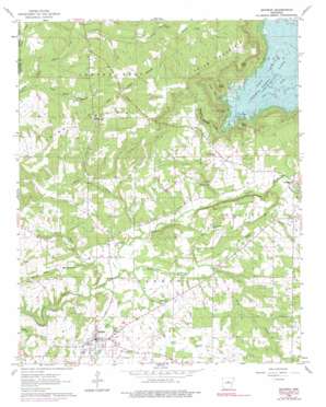
Quitman Topo Map Arkansas
To zoom in, hover over the map of Quitman
USGS Topo Quad 35092d2 - 1:24,000 scale
| Topo Map Name: | Quitman |
| USGS Topo Quad ID: | 35092d2 |
| Print Size: | ca. 21 1/4" wide x 27" high |
| Southeast Coordinates: | 35.375° N latitude / 92.125° W longitude |
| Map Center Coordinates: | 35.4375° N latitude / 92.1875° W longitude |
| U.S. State: | AR |
| Filename: | o35092d2.jpg |
| Download Map JPG Image: | Quitman topo map 1:24,000 scale |
| Map Type: | Topographic |
| Topo Series: | 7.5´ |
| Map Scale: | 1:24,000 |
| Source of Map Images: | United States Geological Survey (USGS) |
| Alternate Map Versions: |
Quitman AR 1963, updated 1964 Download PDF Buy paper map Quitman AR 1963, updated 1976 Download PDF Buy paper map Quitman AR 1963, updated 1990 Download PDF Buy paper map Quitman AR 1991, updated 1995 Download PDF Buy paper map Quitman AR 2011 Download PDF Buy paper map Quitman AR 2014 Download PDF Buy paper map |
1:24,000 Topo Quads surrounding Quitman
> Back to 35092a1 at 1:100,000 scale
> Back to 35092a1 at 1:250,000 scale
> Back to U.S. Topo Maps home
Quitman topo map: Gazetteer
Quitman: Bays
Goff Cove elevation 134m 439′Quitman: Capes
Bean Point elevation 214m 702′Goff Point elevation 231m 757′
Quitman: Dams
Kennedy Lake Dam elevation 235m 770′Miss Jenny Lake Dam elevation 269m 882′
Quitman: Parks
Cove Creek Recreation Area elevation 156m 511′Quitman: Populated Places
Crossroads elevation 297m 974′Pearson elevation 197m 646′
Quitman elevation 178m 583′
Quitman: Reservoirs
Kennedy Lake elevation 235m 770′Miss Jenny Lake elevation 269m 882′
Quitman: Streams
Beaver Creek elevation 168m 551′Bettis Creek elevation 175m 574′
Blue Branch elevation 173m 567′
Flat Rock Creek elevation 209m 685′
Jackson Creek elevation 175m 574′
Mill Creek elevation 166m 544′
Piney Creek elevation 175m 574′
Tabernacle Branch elevation 253m 830′
Taylor Branch elevation 185m 606′
Ward Creek elevation 169m 554′
Yellow Bank Creek elevation 164m 538′
Quitman: Summits
Bettis Mountain elevation 237m 777′Pryor Mountain elevation 322m 1056′
Round Mountain elevation 249m 816′
Quitman: Valleys
Sulphur Springs Hollow elevation 149m 488′Sweet Suck Hollow elevation 148m 485′
Quitman digital topo map on disk
Buy this Quitman topo map showing relief, roads, GPS coordinates and other geographical features, as a high-resolution digital map file on DVD:


