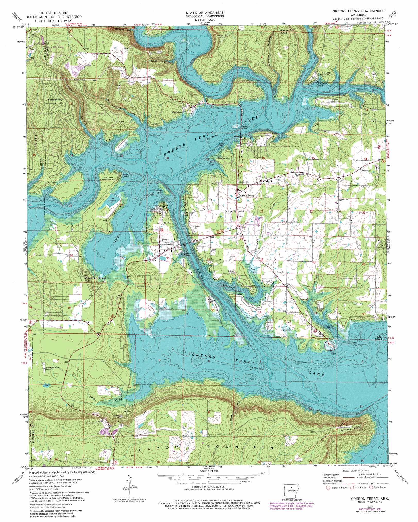
Greers Ferry Topo Map Arkansas
To zoom in, hover over the map of Greers Ferry
USGS Topo Quad 35092e2 - 1:24,000 scale
| Topo Map Name: | Greers Ferry |
| USGS Topo Quad ID: | 35092e2 |
| Print Size: | ca. 21 1/4" wide x 27" high |
| Southeast Coordinates: | 35.5° N latitude / 92.125° W longitude |
| Map Center Coordinates: | 35.5625° N latitude / 92.1875° W longitude |
| U.S. State: | AR |
| Filename: | o35092e2.jpg |
| Download Map JPG Image: | Greers Ferry topo map 1:24,000 scale |
| Map Type: | Topographic |
| Topo Series: | 7.5´ |
| Map Scale: | 1:24,000 |
| Source of Map Images: | United States Geological Survey (USGS) |
| Alternate Map Versions: |
Greers Ferry AR 1973, updated 1975 Download PDF Buy paper map Greers Ferry AR 1973, updated 1982 Download PDF Buy paper map Greers Ferry AR 2011 Download PDF Buy paper map Greers Ferry AR 2014 Download PDF Buy paper map |
1:24,000 Topo Quads surrounding Greers Ferry
Oxley |
Fox |
Mountain View Sw |
Mountain View |
Marcella |
Old Lexington |
Shirley |
Parma |
Prim |
Drasco |
Clinton |
Fairfield Bay |
Greers Ferry |
Brownsville |
Greers Ferry Dam |
Bee Branch |
Morganton |
Quitman |
Heber Springs |
West Pangburn |
Damascus |
Guy |
Barney |
Rose Bud |
Sidon |
> Back to 35092e1 at 1:100,000 scale
> Back to 35092a1 at 1:250,000 scale
> Back to U.S. Topo Maps home
Greers Ferry topo map: Gazetteer
Greers Ferry: Airports
Bondair Airport elevation 151m 495′Greers Ferry: Bays
Higden Bay elevation 137m 449′Hurricane Bay elevation 139m 456′
Greers Ferry: Bridges
Edgemont Bridge elevation 139m 456′Greers Ferry: Capes
Millers Point elevation 294m 964′Greers Ferry: Crossings
Upper Ferry (historical) elevation 137m 449′Greers Ferry: Dams
Dunaway Lake Dam elevation 253m 830′Greers Ferry Nursery Pond Dam elevation 143m 469′
Greers Ferry: Islands
Poker Hill elevation 149m 488′Taylor Island elevation 141m 462′
Greers Ferry: Parks
Devils Fork Recreation Area elevation 144m 472′Hill Creek Recreation Area elevation 161m 528′
Mill Creek Recreation Area elevation 158m 518′
Narrows Recreation Area elevation 154m 505′
Shiloh Recreation Area elevation 148m 485′
Greers Ferry: Populated Places
Chalk (historical) elevation 188m 616′Edgemont elevation 173m 567′
Greers Ferry elevation 185m 606′
Higden elevation 161m 528′
Lone Pine elevation 219m 718′
Post Oak elevation 180m 590′
Shiloh (historical) elevation 139m 456′
Whispering Springs elevation 203m 666′
Greers Ferry: Reservoirs
Dunaway Lake elevation 253m 830′Greers Ferry Nursery Pond elevation 143m 469′
Greers Ferry: Streams
Devils Fork Little Red River elevation 137m 449′Hill Creek elevation 137m 449′
Hurricane Creek elevation 138m 452′
Salt Creek elevation 134m 439′
Shiloh Creek elevation 134m 439′
Wagon Branch elevation 136m 446′
Greers Ferry: Summits
Wilburn Knob elevation 327m 1072′Greers Ferry: Valleys
Bird Hollow elevation 137m 449′Eva Turnley Hollow elevation 138m 452′
Goodin Hollow elevation 137m 449′
Jake Hollow elevation 138m 452′
Stewart Hollow elevation 136m 446′
Wildcat Hollow elevation 136m 446′
Greers Ferry digital topo map on disk
Buy this Greers Ferry topo map showing relief, roads, GPS coordinates and other geographical features, as a high-resolution digital map file on DVD: