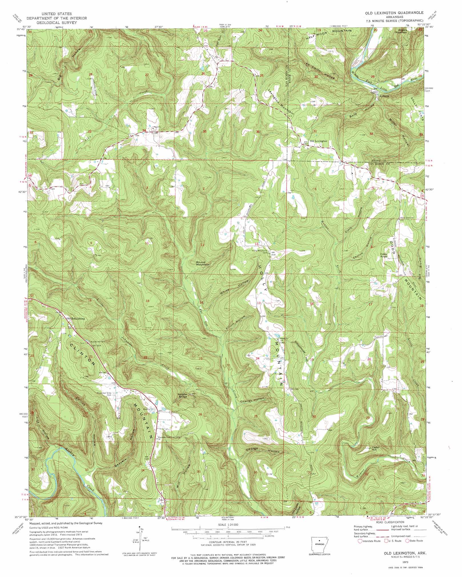
Old Lexington Topo Map Arkansas
To zoom in, hover over the map of Old Lexington
USGS Topo Quad 35092f4 - 1:24,000 scale
| Topo Map Name: | Old Lexington |
| USGS Topo Quad ID: | 35092f4 |
| Print Size: | ca. 21 1/4" wide x 27" high |
| Southeast Coordinates: | 35.625° N latitude / 92.375° W longitude |
| Map Center Coordinates: | 35.6875° N latitude / 92.4375° W longitude |
| U.S. State: | AR |
| Filename: | o35092f4.jpg |
| Download Map JPG Image: | Old Lexington topo map 1:24,000 scale |
| Map Type: | Topographic |
| Topo Series: | 7.5´ |
| Map Scale: | 1:24,000 |
| Source of Map Images: | United States Geological Survey (USGS) |
| Alternate Map Versions: |
Old Lexington AR 1973, updated 1975 Download PDF Buy paper map Old Lexington AR 1973, updated 1975 Download PDF Buy paper map Old Lexington AR 1976, updated 1977 Download PDF Buy paper map Old Lexington AR 2011 Download PDF Buy paper map Old Lexington AR 2014 Download PDF Buy paper map |
1:24,000 Topo Quads surrounding Old Lexington
Marshall |
Harriet |
Landis |
Onia |
Fiftysix |
Canaan |
Leslie |
Oxley |
Fox |
Mountain View Sw |
Alread |
Botkinburg |
Old Lexington |
Shirley |
Parma |
Rex |
Scotland |
Clinton |
Fairfield Bay |
Greers Ferry |
Cleveland |
Formosa |
Bee Branch |
Morganton |
Quitman |
> Back to 35092e1 at 1:100,000 scale
> Back to 35092a1 at 1:250,000 scale
> Back to U.S. Topo Maps home
Old Lexington topo map: Gazetteer
Old Lexington: Airports
Garretts Roost Airport elevation 400m 1312′Old Lexington: Arches
Natural Bridge of Arkansas elevation 270m 885′Old Lexington: Populated Places
Arlberg elevation 207m 679′Old Botkinburg elevation 422m 1384′
Old Lexington elevation 410m 1345′
Plant elevation 391m 1282′
Old Lexington: Streams
Big Branch elevation 351m 1151′Little Johnnies Creek elevation 198m 649′
Old Lexington: Summits
Cedar Hill elevation 328m 1076′Clinton Mountain elevation 477m 1564′
Coley Knob elevation 420m 1377′
Holly Mountain elevation 418m 1371′
Lexington Mountain elevation 438m 1437′
Round Mountain elevation 258m 846′
Old Lexington: Valleys
Ab Smith Hollow elevation 210m 688′Bane Hollow elevation 209m 685′
Beavers Hollow elevation 168m 551′
Charles Hollow elevation 201m 659′
Church Hollow elevation 321m 1053′
Clark Hollow elevation 330m 1082′
Collins Hollow elevation 173m 567′
Elliott Hollow elevation 222m 728′
George Hollow elevation 199m 652′
Lick Hollow elevation 174m 570′
Miller Hollow elevation 215m 705′
Schoolhouse Hollow elevation 289m 948′
White Hollow elevation 235m 770′
Old Lexington digital topo map on disk
Buy this Old Lexington topo map showing relief, roads, GPS coordinates and other geographical features, as a high-resolution digital map file on DVD: