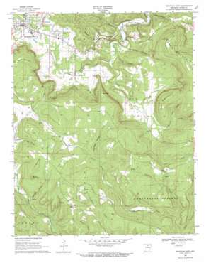
Mountain View Topo Map Arkansas
To zoom in, hover over the map of Mountain View
USGS Topo Quad 35092g1 - 1:24,000 scale
| Topo Map Name: | Mountain View |
| USGS Topo Quad ID: | 35092g1 |
| Print Size: | ca. 21 1/4" wide x 27" high |
| Southeast Coordinates: | 35.75° N latitude / 92° W longitude |
| Map Center Coordinates: | 35.8125° N latitude / 92.0625° W longitude |
| U.S. State: | AR |
| Filename: | o35092g1.jpg |
| Download Map JPG Image: | Mountain View topo map 1:24,000 scale |
| Map Type: | Topographic |
| Topo Series: | 7.5´ |
| Map Scale: | 1:24,000 |
| Source of Map Images: | United States Geological Survey (USGS) |
| Alternate Map Versions: |
Mountain View AR 1969, updated 1971 Download PDF Buy paper map Mountain View AR 2011 Download PDF Buy paper map Mountain View AR 2014 Download PDF Buy paper map |
1:24,000 Topo Quads surrounding Mountain View
> Back to 35092e1 at 1:100,000 scale
> Back to 35092a1 at 1:250,000 scale
> Back to U.S. Topo Maps home
Mountain View topo map: Gazetteer
Mountain View: Airports
Harry E Wilcox Memorial Field elevation 241m 790′Stone County Medical Center Heliport elevation 327m 1072′
Mountain View: Cliffs
Simpson Point elevation 260m 853′Mountain View: Gaps
Star Gap elevation 328m 1076′Mountain View: Pillars
Stack Rock elevation 386m 1266′Mountain View: Populated Places
Hanover elevation 279m 915′Luber elevation 369m 1210′
Mountain View elevation 232m 761′
Mountain View: Streams
Cove Prong elevation 148m 485′Little Raccoon Creek elevation 216m 708′
Mill Prong elevation 145m 475′
North Corn Creek elevation 178m 583′
Possum Creek elevation 223m 731′
Mountain View: Summits
Cedar Mountain elevation 396m 1299′Cooper Point elevation 390m 1279′
Dodd Mountain elevation 428m 1404′
Irons Mountain elevation 477m 1564′
Kemp Hill elevation 386m 1266′
Prince Hill elevation 388m 1272′
Round Mountain elevation 375m 1230′
Tater Hill elevation 354m 1161′
Mountain View: Valleys
Big Gum Hollow elevation 275m 902′Big Hollow elevation 114m 374′
Cave Hollow elevation 220m 721′
Clark Hollow elevation 117m 383′
Flat Rock Hollow elevation 285m 935′
Hanes Hollow elevation 191m 626′
Harrigan Hollow elevation 244m 800′
Hill Hollow elevation 220m 721′
Hinkle Hollow elevation 142m 465′
Holt Hollow elevation 275m 902′
Hub Hollow elevation 300m 984′
Ike Brown Hollow elevation 129m 423′
Lute Hollow elevation 126m 413′
Ripley Hollow elevation 182m 597′
Wade Hollow elevation 126m 413′
Mountain View digital topo map on disk
Buy this Mountain View topo map showing relief, roads, GPS coordinates and other geographical features, as a high-resolution digital map file on DVD:


