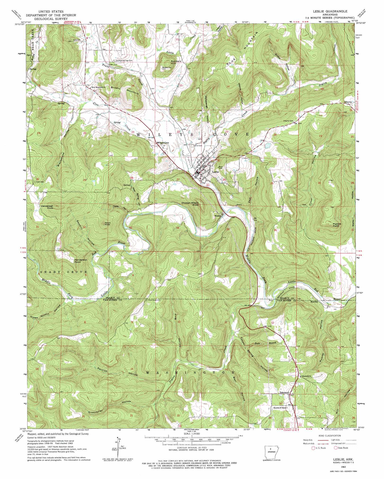
Leslie Topo Map Arkansas
To zoom in, hover over the map of Leslie
USGS Topo Quad 35092g5 - 1:24,000 scale
| Topo Map Name: | Leslie |
| USGS Topo Quad ID: | 35092g5 |
| Print Size: | ca. 21 1/4" wide x 27" high |
| Southeast Coordinates: | 35.75° N latitude / 92.5° W longitude |
| Map Center Coordinates: | 35.8125° N latitude / 92.5625° W longitude |
| U.S. State: | AR |
| Filename: | o35092g5.jpg |
| Download Map JPG Image: | Leslie topo map 1:24,000 scale |
| Map Type: | Topographic |
| Topo Series: | 7.5´ |
| Map Scale: | 1:24,000 |
| Source of Map Images: | United States Geological Survey (USGS) |
| Alternate Map Versions: |
Leslie AR 1963, updated 1964 Download PDF Buy paper map Leslie AR 2011 Download PDF Buy paper map Leslie AR 2014 Download PDF Buy paper map |
1:24,000 Topo Quads surrounding Leslie
Saint Joe |
Maumee |
Cozahome |
Big Flat |
Norfork Se |
Snowball |
Marshall |
Harriet |
Landis |
Onia |
Witts Spring |
Canaan |
Leslie |
Oxley |
Fox |
Tilly |
Alread |
Botkinburg |
Old Lexington |
Shirley |
Lost Corner |
Rex |
Scotland |
Clinton |
Fairfield Bay |
> Back to 35092e1 at 1:100,000 scale
> Back to 35092a1 at 1:250,000 scale
> Back to U.S. Topo Maps home
Leslie topo map: Gazetteer
Leslie: Cliffs
Henderson Point elevation 484m 1587′Leslie: Dams
Baker Lake Dam elevation 470m 1541′Leslie: Populated Places
Dennard elevation 460m 1509′Elberta elevation 491m 1610′
Leslie elevation 310m 1017′
Noahs elevation 287m 941′
Oak Flat (historical) elevation 304m 997′
Rumley elevation 277m 908′
Wileys Cove elevation 310m 1017′
Leslie: Post Offices
Dennard Post Office elevation 448m 1469′Leslie: Reservoirs
Baker Lake elevation 470m 1541′Leslie: Streams
Begley Creek elevation 287m 941′Cove Creek elevation 287m 941′
Kelley Creek elevation 337m 1105′
Kimbrell Creek elevation 337m 1105′
Little Creek elevation 305m 1000′
Peyton Creek elevation 287m 941′
Poole Branch elevation 320m 1049′
Trace Creek elevation 295m 967′
Leslie: Summits
Baldwin Hill elevation 411m 1348′Blue Mountain elevation 528m 1732′
Brushy Mountain elevation 415m 1361′
Chicken Wilson Knob elevation 449m 1473′
Henderson Knob elevation 553m 1814′
Nolan Knob elevation 447m 1466′
Pipkins Point elevation 461m 1512′
Leslie: Valleys
Bear Hollow elevation 300m 984′Blacksnake Hollow elevation 318m 1043′
Cedar Hollow elevation 301m 987′
Copper Spring Hollow elevation 292m 958′
Eadl Hollow elevation 289m 948′
Gibbins Hollow elevation 315m 1033′
Green Griffin Hollow elevation 320m 1049′
Greenbrier Hollow elevation 333m 1092′
Griffin Hollow elevation 332m 1089′
Happy Hollow elevation 328m 1076′
Hollabaugh Hollow elevation 304m 997′
King Hollow elevation 310m 1017′
Rumley Hollow elevation 272m 892′
Sawmill Hollow elevation 311m 1020′
Section Hollow elevation 340m 1115′
Watts Hollow elevation 287m 941′
West Spring Hollow elevation 299m 980′
Leslie digital topo map on disk
Buy this Leslie topo map showing relief, roads, GPS coordinates and other geographical features, as a high-resolution digital map file on DVD: