Witts Spring Topo Map Arkansas
To zoom in, hover over the map of Witts Spring
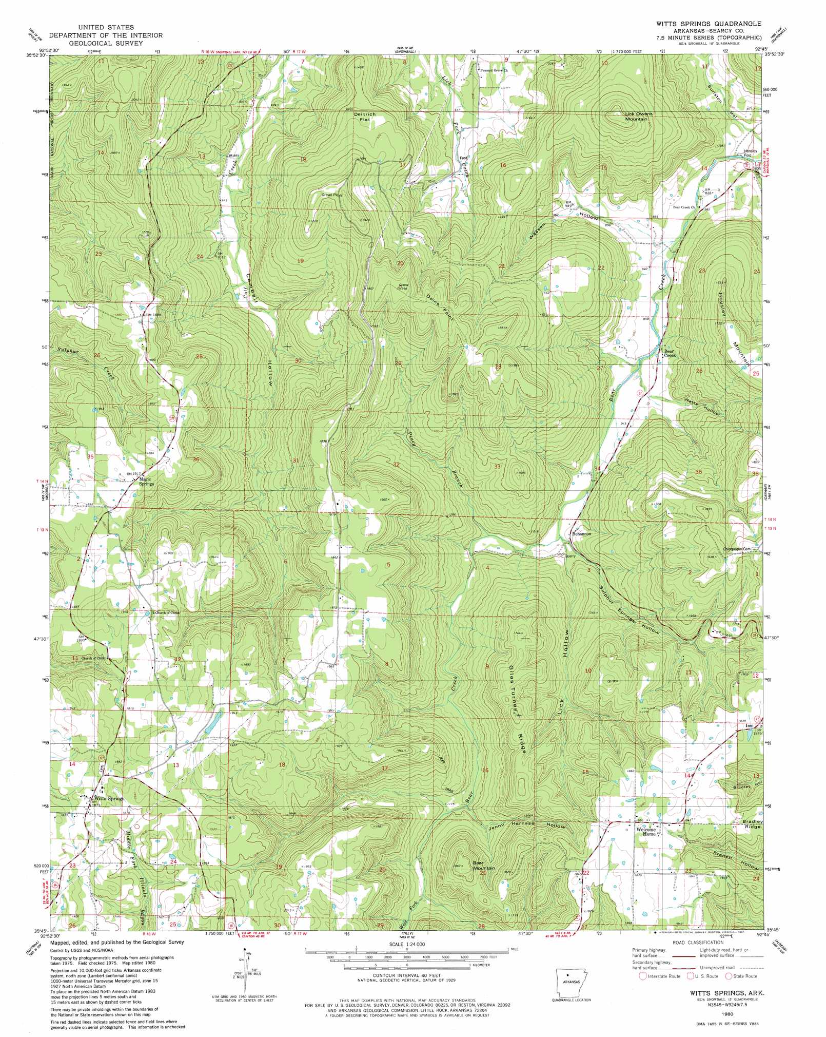
USGS Topo Quad 35092g7 - 1:24,000 scale
| Topo Map Name: | Witts Spring |
| USGS Topo Quad ID: | 35092g7 |
| Print Size: | ca. 21 1/4" wide x 27" high |
| Southeast Coordinates: | 35.75° N latitude / 92.75° W longitude |
| Map Center Coordinates: | 35.8125° N latitude / 92.8125° W longitude |
| U.S. State: | AR |
| Filename: | o35092g7.jpg |
| Download Map JPG Image: | Witts Spring topo map 1:24,000 scale |
| Map Type: | Topographic |
| Topo Series: | 7.5´ |
| Map Scale: | 1:24,000 |
| Source of Map Images: | United States Geological Survey (USGS) |
| Alternate Map Versions: |
Snowball SE AR 1974, updated 1975 Download PDF Buy paper map Witts Springs AR 1980, updated 1981 Download PDF Buy paper map Witts Springs AR 2011 Download PDF Buy paper map Witts Springs AR 2014 Download PDF Buy paper map |
| FStopo: | US Forest Service topo Witts Springs is available: Download FStopo PDF Download FStopo TIF |
1:24,000 Topo Quads surrounding Witts Spring
Hasty |
Western Grove |
Saint Joe |
Maumee |
Cozahome |
Mount Judea |
Eula |
Snowball |
Marshall |
Harriet |
Lurton |
Moore |
Witts Spring |
Canaan |
Leslie |
Sand Gap |
Smyrna |
Tilly |
Alread |
Botkinburg |
Simpson |
Solo |
Lost Corner |
Rex |
Scotland |
> Back to 35092e1 at 1:100,000 scale
> Back to 35092a1 at 1:250,000 scale
> Back to U.S. Topo Maps home
Witts Spring topo map: Gazetteer
Witts Spring: Cliffs
Doins Point elevation 498m 1633′Witts Spring: Crossings
Hensley Ford elevation 242m 793′Witts Spring: Flats
Deitrich Flat elevation 430m 1410′Witts Spring: Populated Places
Bear Creek elevation 271m 889′Bohannon elevation 296m 971′
Imo elevation 561m 1840′
Magic Springs elevation 584m 1916′
Welcome Home elevation 573m 1879′
Witts Springs elevation 584m 1916′
Witts Spring: Ridges
Bradley Ridge elevation 562m 1843′Giles Turney Ridge elevation 526m 1725′
Witts Spring: Streams
Piney Branch elevation 296m 971′Sulphur Spring Branch elevation 285m 935′
West Fork Bear Creek elevation 285m 935′
Witts Spring: Summits
Bear Mountain elevation 565m 1853′Housley Mountain elevation 521m 1709′
Lick Owens Mountain elevation 570m 1870′
Witts Spring: Valleys
Burlston Hollow elevation 243m 797′Jenny Harness Hollow elevation 365m 1197′
Lick Hollow elevation 292m 958′
Sulphur Springs Hollow elevation 291m 954′
Wassen Hollow elevation 254m 833′
Watts Hollow elevation 273m 895′
Witts Spring digital topo map on disk
Buy this Witts Spring topo map showing relief, roads, GPS coordinates and other geographical features, as a high-resolution digital map file on DVD: