Ola Topo Map Arkansas
To zoom in, hover over the map of Ola
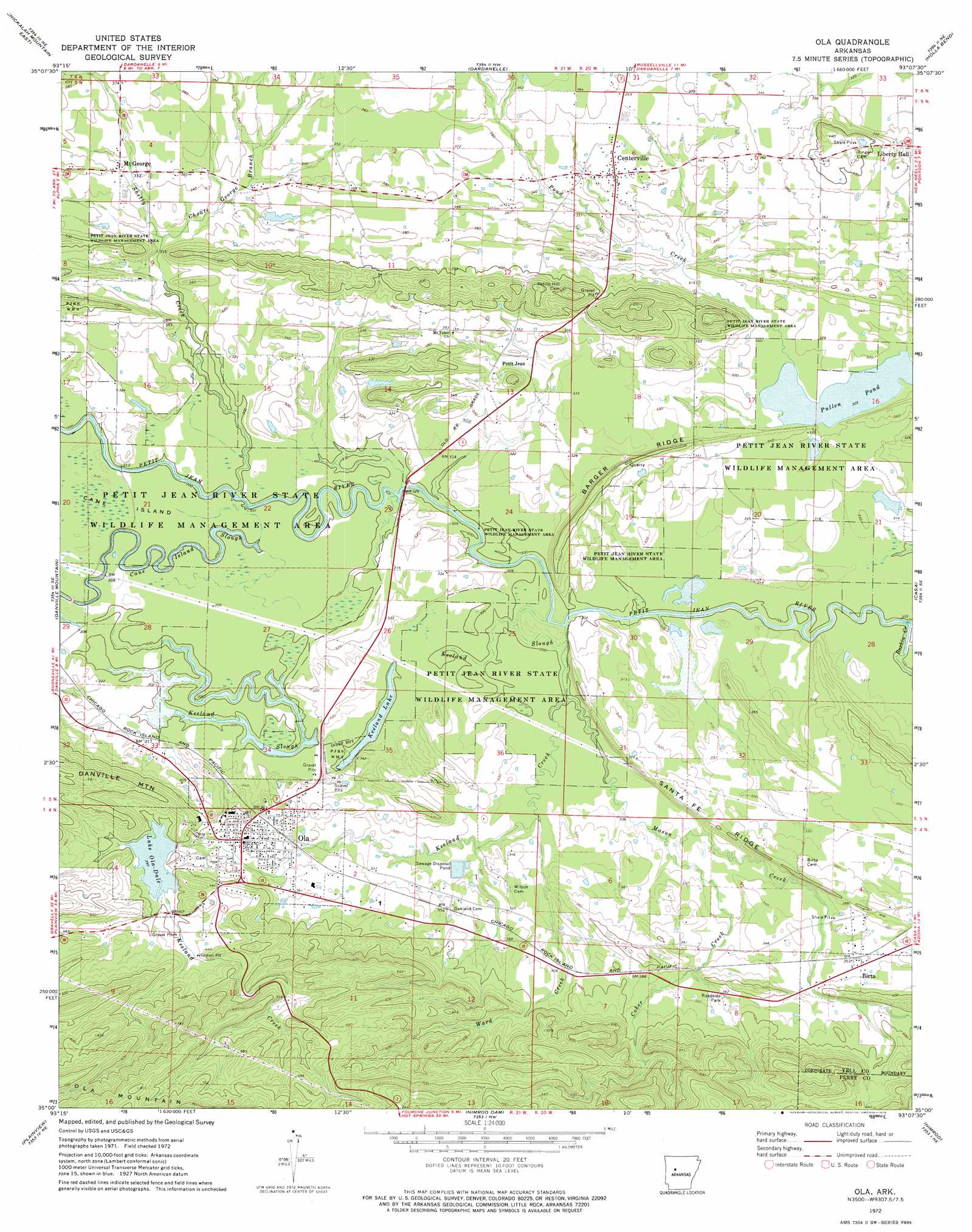
USGS Topo Quad 35093a2 - 1:24,000 scale
| Topo Map Name: | Ola |
| USGS Topo Quad ID: | 35093a2 |
| Print Size: | ca. 21 1/4" wide x 27" high |
| Southeast Coordinates: | 35° N latitude / 93.125° W longitude |
| Map Center Coordinates: | 35.0625° N latitude / 93.1875° W longitude |
| U.S. State: | AR |
| Filename: | o35093a2.jpg |
| Download Map JPG Image: | Ola topo map 1:24,000 scale |
| Map Type: | Topographic |
| Topo Series: | 7.5´ |
| Map Scale: | 1:24,000 |
| Source of Map Images: | United States Geological Survey (USGS) |
| Alternate Map Versions: |
Ola AR 1972, updated 1974 Download PDF Buy paper map Ola AR 1972, updated 1974 Download PDF Buy paper map Ola AR 2011 Download PDF Buy paper map Ola AR 2014 Download PDF Buy paper map |
1:24,000 Topo Quads surrounding Ola
New Blaine |
Delaware |
Russellville West |
Russellville East |
Moreland |
Chickalah Mountain West |
Chickalah Mountain East |
Dardanelle |
Holla Bend |
Atkins |
Danville |
Danville Mountain |
Ola |
Casa |
Adona |
Rover |
Plainview |
Nimrod Dam |
Nimrod |
Aplin |
Onyx |
Steve |
Nimrod Sw |
Nimrod Se |
Paron Sw |
> Back to 35093a1 at 1:100,000 scale
> Back to 35092a1 at 1:250,000 scale
> Back to U.S. Topo Maps home
Ola topo map: Gazetteer
Ola: Crossings
Rocky Crossing elevation 96m 314′Ola: Dams
Mockingbird Hill Lake Dam elevation 101m 331′Schoonover Lake Dam elevation 119m 390′
Ola: Guts
Keeland Slough elevation 91m 298′Keeland Slough elevation 93m 305′
Ola: Lakes
Keeland Lake elevation 90m 295′Ola: Parks
Petit Jean River State Wildlife Management Area elevation 101m 331′Ola: Populated Places
Birta elevation 107m 351′Centerville elevation 103m 337′
Mount George elevation 104m 341′
Ola elevation 110m 360′
Petit Jean elevation 100m 328′
Ola: Post Offices
Centerville Post Office elevation 103m 337′Ola: Reservoirs
Lake Ola-dale elevation 119m 390′Mockingbird Hill Lake elevation 101m 331′
Schoonover Lake elevation 119m 390′
Ola: Ridges
Barger Ridge elevation 111m 364′Santa Fe Ridge elevation 119m 390′
Ola: Streams
Baskin Creek elevation 88m 288′Choate George Branch elevation 92m 301′
Coker Creek elevation 95m 311′
Keeland Creek elevation 91m 298′
Mason Creek elevation 89m 291′
Shetty Creek elevation 92m 301′
Ward Creek elevation 94m 308′
Ola digital topo map on disk
Buy this Ola topo map showing relief, roads, GPS coordinates and other geographical features, as a high-resolution digital map file on DVD: