Holla Bend Topo Map Arkansas
To zoom in, hover over the map of Holla Bend
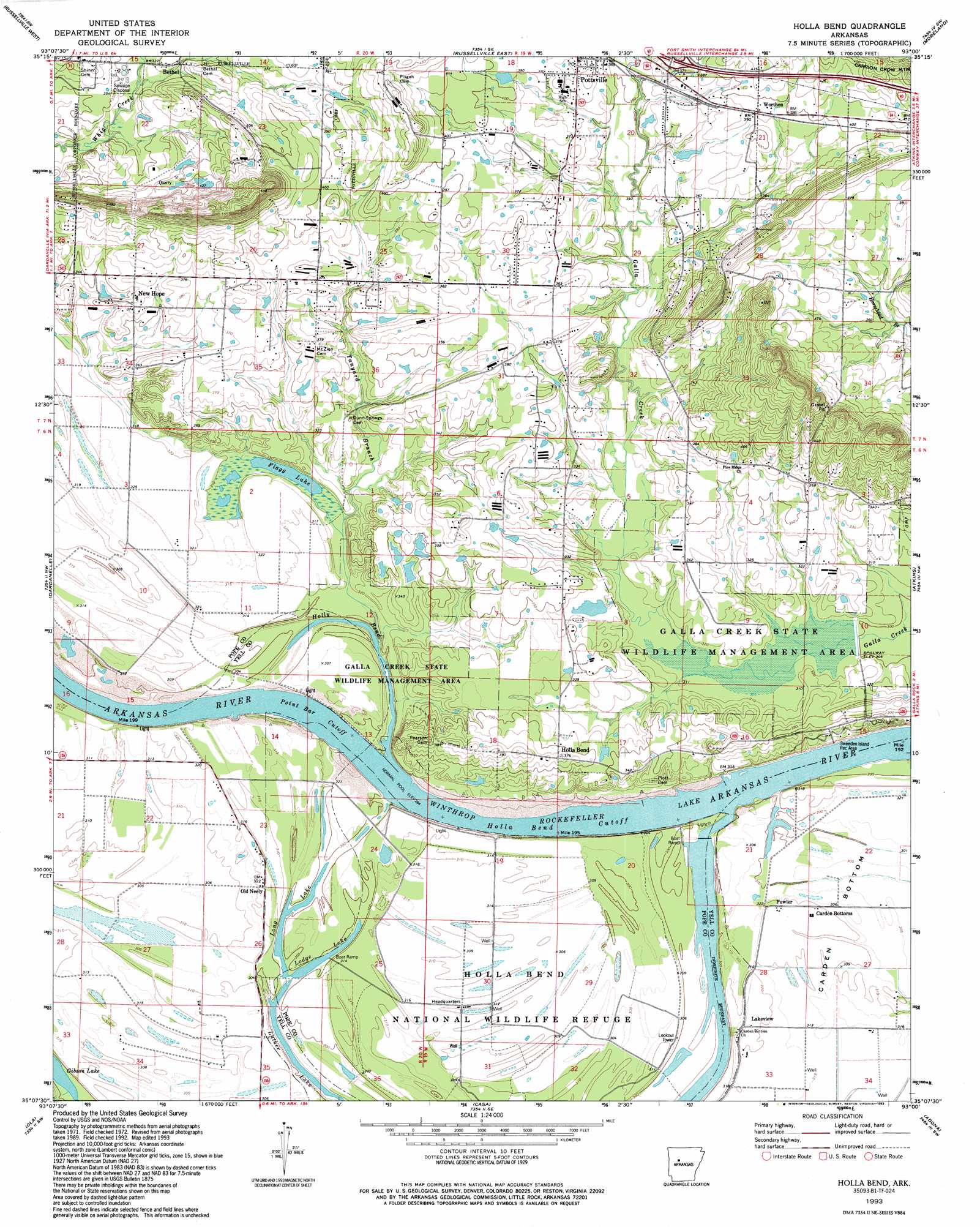
USGS Topo Quad 35093b1 - 1:24,000 scale
| Topo Map Name: | Holla Bend |
| USGS Topo Quad ID: | 35093b1 |
| Print Size: | ca. 21 1/4" wide x 27" high |
| Southeast Coordinates: | 35.125° N latitude / 93° W longitude |
| Map Center Coordinates: | 35.1875° N latitude / 93.0625° W longitude |
| U.S. State: | AR |
| Filename: | o35093b1.jpg |
| Download Map JPG Image: | Holla Bend topo map 1:24,000 scale |
| Map Type: | Topographic |
| Topo Series: | 7.5´ |
| Map Scale: | 1:24,000 |
| Source of Map Images: | United States Geological Survey (USGS) |
| Alternate Map Versions: |
Holla Bend AR 1972, updated 1974 Download PDF Buy paper map Holla Bend AR 1972, updated 1990 Download PDF Buy paper map Holla Bend AR 1993, updated 1993 Download PDF Buy paper map Holla Bend AR 2011 Download PDF Buy paper map Holla Bend AR 2014 Download PDF Buy paper map |
1:24,000 Topo Quads surrounding Holla Bend
Knoxville |
Lee Mountain |
Dover |
Hector |
Jerusalem |
Delaware |
Russellville West |
Russellville East |
Moreland |
Hattieville |
Chickalah Mountain East |
Dardanelle |
Holla Bend |
Atkins |
Morrilton West |
Danville Mountain |
Ola |
Casa |
Adona |
Perryville |
Plainview |
Nimrod Dam |
Nimrod |
Aplin |
Thornburg |
> Back to 35093a1 at 1:100,000 scale
> Back to 35092a1 at 1:250,000 scale
> Back to U.S. Topo Maps home
Holla Bend topo map: Gazetteer
Holla Bend: Bends
Howells Bend elevation 94m 308′Neelys Bend elevation 87m 285′
Point Bar Cutoff elevation 83m 272′
Holla Bend: Channels
Holla Bend Cutoff elevation 85m 278′Holla Bend: Crossings
Interstate 88 elevation 112m 367′Reeds Ferry (historical) elevation 85m 278′
Holla Bend: Dams
Galla Creek State Wildlife Lake Dam elevation 92m 301′Jones Lake Dam elevation 112m 367′
Lake Irvin Dam elevation 98m 321′
Holla Bend: Lakes
Flagg Lake elevation 94m 308′Holla Bend elevation 89m 291′
Lodge Lake elevation 87m 285′
Long Lake elevation 89m 291′
Luther Lake elevation 85m 278′
Open Slough elevation 86m 282′
Holla Bend: Parks
Galla Creek State Wildlife Management Area elevation 95m 311′Holla Bend National Wildlife Refuge elevation 93m 305′
Sweeden Island Park elevation 100m 328′
Holla Bend: Populated Places
Bethel elevation 106m 347′Carden Bottoms elevation 92m 301′
Fowler elevation 93m 305′
Holla Bend elevation 111m 364′
Lakeview elevation 95m 311′
New Hope elevation 110m 360′
Old Neely elevation 96m 314′
Pisgah (historical) elevation 133m 436′
Pottsville elevation 113m 370′
Worthen elevation 119m 390′
Holla Bend: Reservoirs
Galla Creek Wildlife Lake elevation 92m 301′Jones Lake elevation 112m 367′
Lake Irvin elevation 98m 321′
Winthrop Rockefeller Lake elevation 85m 278′
Holla Bend: Streams
Tanyard Branch elevation 94m 308′Holla Bend digital topo map on disk
Buy this Holla Bend topo map showing relief, roads, GPS coordinates and other geographical features, as a high-resolution digital map file on DVD: