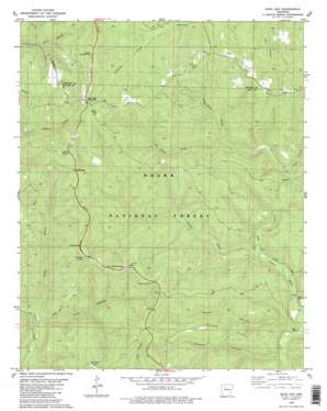
Sand Gap Topo Map Arkansas
To zoom in, hover over the map of Sand Gap
USGS Topo Quad 35093f1 - 1:24,000 scale
| Topo Map Name: | Sand Gap |
| USGS Topo Quad ID: | 35093f1 |
| Print Size: | ca. 21 1/4" wide x 27" high |
| Southeast Coordinates: | 35.625° N latitude / 93° W longitude |
| Map Center Coordinates: | 35.6875° N latitude / 93.0625° W longitude |
| U.S. State: | AR |
| Filename: | o35093f1.jpg |
| Download Map JPG Image: | Sand Gap topo map 1:24,000 scale |
| Map Type: | Topographic |
| Topo Series: | 7.5´ |
| Map Scale: | 1:24,000 |
| Source of Map Images: | United States Geological Survey (USGS) |
| Alternate Map Versions: |
Treat NE AR 1974, updated 1975 Download PDF Buy paper map Sand Gap AR 1980, updated 1980 Download PDF Buy paper map Sand Gap AR 1980, updated 1980 Download PDF Buy paper map Sand Gap AR 2011 Download PDF Buy paper map Sand Gap AR 2014 Download PDF Buy paper map |
| FStopo: | US Forest Service topo Sand Gap is available: Download FStopo PDF Download FStopo TIF |
1:24,000 Topo Quads surrounding Sand Gap
> Back to 35093e1 at 1:100,000 scale
> Back to 35092a1 at 1:250,000 scale
> Back to U.S. Topo Maps home
Sand Gap topo map: Gazetteer
Sand Gap: Arches
Arch Rock elevation 485m 1591′Pedestal Rocks elevation 503m 1650′
Sand Gap: Gaps
Muddy Gap elevation 531m 1742′Sand Gap: Parks
Fairview Recreation Area elevation 666m 2185′Sand Gap: Populated Places
Freeman Springs elevation 593m 1945′Sand Gap elevation 598m 1961′
Victor elevation 269m 882′
Sand Gap: Post Offices
Pelsor Post Office elevation 427m 1400′Sand Gap: Ridges
Payne Ridge elevation 411m 1348′Sand Gap: Springs
Freeman Springs elevation 603m 1978′Sand Gap: Streams
Cedar Creek elevation 323m 1059′Gunter Branch elevation 235m 770′
Left Hand Prong elevation 369m 1210′
Nowlin Creek elevation 240m 787′
Nowlin Creek elevation 239m 784′
Payne Creek elevation 248m 813′
Payne Creek elevation 248m 813′
Right Hand Prong elevation 366m 1200′
Sulphur Creek elevation 282m 925′
Sand Gap: Summits
Burgiss Knob elevation 594m 1948′Dare Mine Knob elevation 601m 1971′
Sollys Knob elevation 631m 2070′
Sand Gap: Trails
Boyd Trail elevation 453m 1486′Cherry Ridge Trail elevation 544m 1784′
Gunter Trail elevation 465m 1525′
Hurricane Trail elevation 520m 1706′
Mail Trail elevation 431m 1414′
Pedestal Rocks Trail elevation 555m 1820′
Silver Point Trail elevation 451m 1479′
Still Hollow Trail elevation 477m 1564′
Sulphur Trail elevation 506m 1660′
Sand Gap: Valleys
Boss Hollow elevation 377m 1236′Boss Hollow elevation 368m 1207′
Nowlin Hollow elevation 242m 793′
Payne Hollow elevation 250m 820′
Still Hollow elevation 237m 777′
Sand Gap digital topo map on disk
Buy this Sand Gap topo map showing relief, roads, GPS coordinates and other geographical features, as a high-resolution digital map file on DVD:


