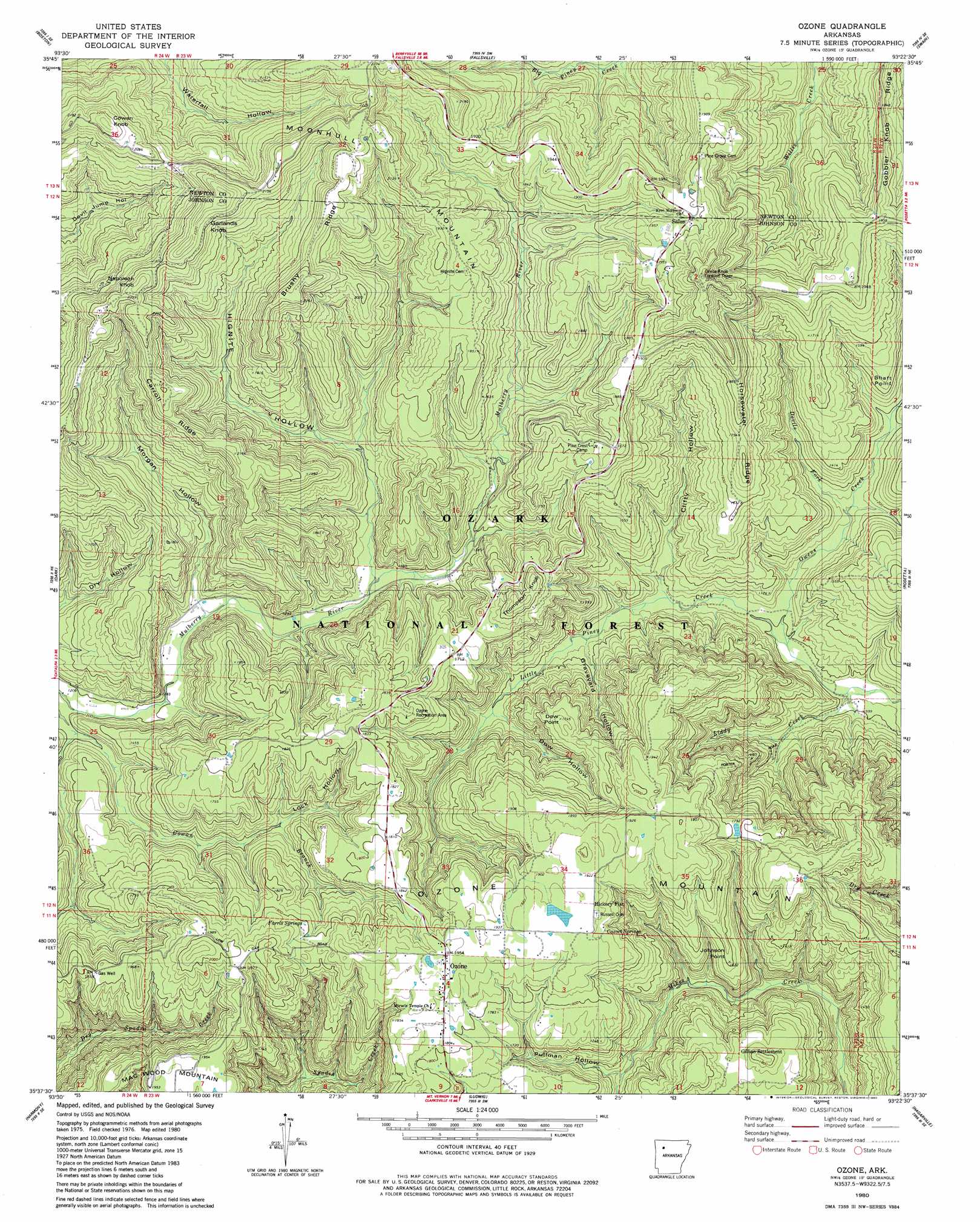
Ozone Topo Map Arkansas
To zoom in, hover over the map of Ozone
USGS Topo Quad 35093f4 - 1:24,000 scale
| Topo Map Name: | Ozone |
| USGS Topo Quad ID: | 35093f4 |
| Print Size: | ca. 21 1/4" wide x 27" high |
| Southeast Coordinates: | 35.625° N latitude / 93.375° W longitude |
| Map Center Coordinates: | 35.6875° N latitude / 93.4375° W longitude |
| U.S. State: | AR |
| Filename: | o35093f4.jpg |
| Download Map JPG Image: | Ozone topo map 1:24,000 scale |
| Map Type: | Topographic |
| Topo Series: | 7.5´ |
| Map Scale: | 1:24,000 |
| Source of Map Images: | United States Geological Survey (USGS) |
| Alternate Map Versions: |
Ozone AR 1980, updated 1980 Download PDF Buy paper map Ozone AR 2011 Download PDF Buy paper map Ozone AR 2014 Download PDF Buy paper map |
| FStopo: | US Forest Service topo Ozone is available: Download FStopo PDF Download FStopo TIF |
1:24,000 Topo Quads surrounding Ozone
Witter |
Weathers |
Boxley |
Murray |
Parthenon |
Pettigrew |
Boston |
Fallsville |
Swain |
Deer |
Yale |
Oark |
Ozone |
Rosetta |
Fort Douglas |
Hunt |
Harmony |
Ludwig |
Hagerville |
Treat |
Coal Hill |
Hartman |
Clarksville |
Knoxville |
Lee Mountain |
> Back to 35093e1 at 1:100,000 scale
> Back to 35092a1 at 1:250,000 scale
> Back to U.S. Topo Maps home
Ozone topo map: Gazetteer
Ozone: Capes
Dow Point elevation 516m 1692′Johnson Point elevation 476m 1561′
Shaft Point elevation 490m 1607′
Ozone: Dams
Lake Ozone Dam elevation 564m 1850′Ozone: Flats
Hickory Flat elevation 580m 1902′Ozone: Oilfields
Ozone Gas Field elevation 590m 1935′Ozone: Parks
Ozone Recreation Area elevation 550m 1804′Ozone: Populated Places
Farris Springs elevation 549m 1801′Gillian Settlement elevation 501m 1643′
Hickory Flat elevation 584m 1916′
Ozone elevation 594m 1948′
Salus elevation 602m 1975′
Ozone: Post Offices
Ozone Post Office elevation 595m 1952′Ozone: Reservoirs
Lake Ozone elevation 564m 1850′Ozone: Ridges
Brushy Ridge elevation 632m 2073′Carroll Ridge elevation 655m 2148′
Gobbler Knob Ridge elevation 560m 1837′
Horsewater Ridge elevation 558m 1830′
Ozone: Springs
Cazort Springs elevation 589m 1932′Farris Springs elevation 549m 1801′
Ozone: Streams
Devils Fork elevation 343m 1125′Liddy Creek elevation 289m 948′
Owens Creek elevation 302m 990′
Ozone: Summits
Cowan Knob elevation 699m 2293′Devils Knob elevation 682m 2237′
Garlands Knob elevation 700m 2296′
Moonhull Mountain elevation 682m 2237′
Napoleon Knob elevation 697m 2286′
Ozone Mountain elevation 595m 1952′
Thompson Knob elevation 563m 1847′
Ozone: Trails
Boston Cutoff elevation 478m 1568′Peggy Steep Trail elevation 458m 1502′
Ozone: Valleys
Clifty Hollow elevation 328m 1076′Dow Hollow elevation 385m 1263′
Graveyard Hollow elevation 357m 1171′
Hignite Hollow elevation 406m 1332′
Lock Hollow elevation 439m 1440′
Morgan Hollow elevation 377m 1236′
Pullman Hollow elevation 416m 1364′
Ozone digital topo map on disk
Buy this Ozone topo map showing relief, roads, GPS coordinates and other geographical features, as a high-resolution digital map file on DVD: