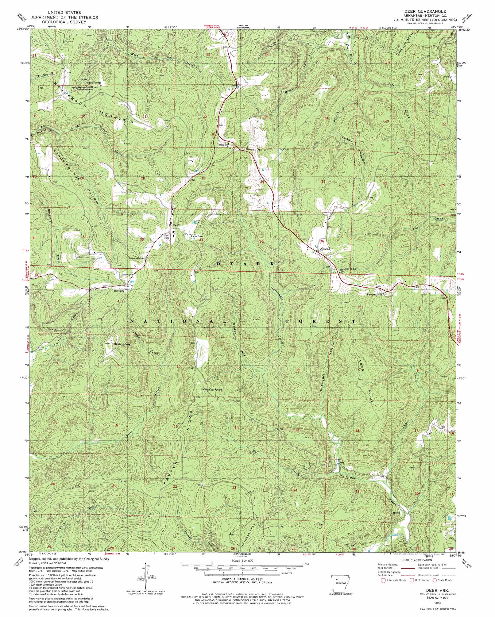
Deer Topo Map Arkansas
To zoom in, hover over the map of Deer
USGS Topo Quad 35093g2 - 1:24,000 scale
| Topo Map Name: | Deer |
| USGS Topo Quad ID: | 35093g2 |
| Print Size: | ca. 21 1/4" wide x 27" high |
| Southeast Coordinates: | 35.75° N latitude / 93.125° W longitude |
| Map Center Coordinates: | 35.8125° N latitude / 93.1875° W longitude |
| U.S. State: | AR |
| Filename: | o35093g2.jpg |
| Download Map JPG Image: | Deer topo map 1:24,000 scale |
| Map Type: | Topographic |
| Topo Series: | 7.5´ |
| Map Scale: | 1:24,000 |
| Source of Map Images: | United States Geological Survey (USGS) |
| Alternate Map Versions: |
Mt Judea SW AR 1974, updated 1975 Download PDF Buy paper map Deer AR 1980, updated 1981 Download PDF Buy paper map Deer AR 2011 Download PDF Buy paper map Deer AR 2014 Download PDF Buy paper map |
| FStopo: | US Forest Service topo Deer is available: Download FStopo PDF Download FStopo TIF |
1:24,000 Topo Quads surrounding Deer
Osage Sw |
Ponca |
Jasper |
Hasty |
Western Grove |
Boxley |
Murray |
Parthenon |
Mount Judea |
Eula |
Fallsville |
Swain |
Deer |
Lurton |
Moore |
Ozone |
Rosetta |
Fort Douglas |
Sand Gap |
Smyrna |
Ludwig |
Hagerville |
Treat |
Simpson |
Solo |
> Back to 35093e1 at 1:100,000 scale
> Back to 35092a1 at 1:250,000 scale
> Back to U.S. Topo Maps home
Deer topo map: Gazetteer
Deer: Arches
Alum Cove Natural Bridge elevation 595m 1952′Deer: Gaps
Norton Gap elevation 643m 2109′Deer: Parks
Alum Cove Natural Bridge Recreation Area elevation 639m 2096′Deer: Populated Places
Chancel elevation 315m 1033′Cowell elevation 668m 2191′
Deer elevation 716m 2349′
Pleasant Hill elevation 639m 2096′
Deer: Post Offices
Deer Post Office elevation 714m 2342′Deer: Ridges
Long Ridge elevation 596m 1955′Parker Ridge elevation 593m 1945′
Deer: Streams
Buck Branch elevation 314m 1030′Cove Branch elevation 393m 1289′
Cub Creek elevation 327m 1072′
Linn Creek elevation 401m 1315′
Little Buffalo Creek elevation 493m 1617′
Mill Creek elevation 338m 1108′
Right Fork Big Creek elevation 339m 1112′
Slusher Creek elevation 390m 1279′
Slusher Creek elevation 412m 1351′
Wolf Creek elevation 393m 1289′
Deer: Summits
Davis Knob elevation 688m 2257′Henderson Mountain elevation 692m 2270′
Hurricane Knob elevation 549m 1801′
Hurricane Knob elevation 588m 1929′
Millsaps Knob elevation 640m 2099′
Owens Mountain elevation 641m 2103′
Deer: Trails
Alum Cove National Recreation Trail elevation 609m 1998′Deer: Valleys
Lambdin Hollow elevation 476m 1561′Lambdin Hollow elevation 468m 1535′
Lonesome Hollow elevation 358m 1174′
Sandy Springs Hollow elevation 493m 1617′
Sandy Springs Hollow elevation 493m 1617′
Slusher Hollow elevation 391m 1282′
Deer digital topo map on disk
Buy this Deer topo map showing relief, roads, GPS coordinates and other geographical features, as a high-resolution digital map file on DVD: